Property Record
1024 State Road 20, Interlachen, FL 32148


NEARBY LISTINGS FOR SALE OR LEASE
-
-
No Photo
-
View all Interlachen listings for sale on LoopNet.com
Property Detail
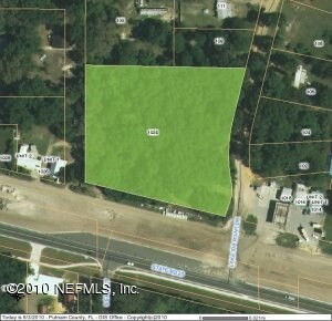
1024 State Road 20
Palatka, FL
Lake Ida Point
14-10-24-4923-0140-0310
PT OF NE1/4 OF NE1/4 OR5 P535, OR259 P197 (LOTS 31 32 LAKE, IDA POINT UNREC) (EX OR108, P531 OR222 P647 OR242 P569, OR246 P31) (SUBJECT TO MINERAL, RIGHTS OR490 P1803)
Commercialacreage
Putnam
X
Florida
12107C0163C
31
2025
2.94 AC
2025
Florida Central North Area
950201
Other Market Areas
DEMOGRAPHICS near 1024 State Road 20
1 mile
3 mile
5 mile
2024 Total Population
1,047
7,004
11,200
2029 Population
1,098
7,309
11,733
Pop Growth 2024-2029
+ 4.87%
+ 4.35%
+ 4.76%
Average Age
45
43
43
2024 Total Households
433
2,842
4,491
HH Growth 2024-2029
+ 4.85%
+ 4.26%
+ 4.65%
Median Household Inc
$40,115
$32,798
$33,035
Avg Household Size
2.40
2.40
2.50
2024 Avg HH Vehicles
2.00
2.00
2.00
Median Home Value
$80,568
$73,650
$73,838
Median Year Built
1987
1986
1987
Nearby Places
Map Layers
Map Styles
 Street
 Aerial
Transit
 Traffic
 Biking
Places
Listings with unknown addresses are not visible on the map
- Restaurants
- Banks
- Shops
- Fitness
- Groceries
PUBLIC TRANSPORTATION
AIRPORT
Gainesville Regional
Drive
Walk
Distance
Gainesville Regional
47 min
33.0 mi
SALE & LEASE HISTORY
LISTING DATE
SALE/LEASE

Sep 25, 2016
For Lease
Sep 24, 2016
For Sale
Dec 07, 2018
For Sale
Nearby Properties
Address
Land Use
TOTAL SIZE
Lot Size
Zoning
Address
Land Use
TOTAL SIZE
Lot Size
Zoning
4,864 SF
39.09 AC
Address
Land Use
TOTAL SIZE
Lot Size
Zoning
97,000 SF
19.64 AC
Address
Land Use
TOTAL SIZE
Lot Size
Zoning
499.30 AC
Address
Land Use
TOTAL SIZE
Lot Size
Zoning
53,086 SF
11.05 AC
Address
Land Use
TOTAL SIZE
Lot Size
Zoning
23,138 SF
7.80 AC
Address
Land Use
TOTAL SIZE
Lot Size
Zoning
11,918 SF
3.91 AC
Address
Land Use
TOTAL SIZE
Lot Size
Zoning
11,683 SF
1.24 AC
Address
Land Use
TOTAL SIZE
Lot Size
Zoning
3.84 AC
Address
Land Use
TOTAL SIZE
Lot Size
Zoning
3,774 SF
7.02 AC
Address
Land Use
TOTAL SIZE
Lot Size
Zoning
3,504 SF
1.28 AC
Address
Land Use
TOTAL SIZE
Lot Size
Zoning
11,864 SF
3 AC
Address
Land Use
TOTAL SIZE
Lot Size
Zoning
14,306 SF
7.13 AC
Address
Land Use
TOTAL SIZE
Lot Size
Zoning
2,330 SF
1.91 AC
Address
Land Use
TOTAL SIZE
Lot Size
Zoning
9,000 SF
1.64 AC
Address
Land Use
TOTAL SIZE
Lot Size
Zoning
3,478 SF
6.87 AC
Address
Land Use
TOTAL SIZE
Lot Size
Zoning
Address
Land Use
TOTAL SIZE
Lot Size
Zoning
Address
Land Use
TOTAL SIZE
Lot Size
Zoning
756 SF
1.35 AC
Address
Land Use
TOTAL SIZE
Lot Size
Zoning
1,452 SF
2.89 AC
Address
Land Use
TOTAL SIZE
Lot Size
Zoning
8,640 SF
2.72 AC
Address
Land Use
TOTAL SIZE
Lot Size
Zoning
7,200 SF
24.47 AC
Address
Land Use
TOTAL SIZE
Lot Size
Zoning
11,037 SF
2.72 AC
Address
Land Use
TOTAL SIZE
Lot Size
Zoning
6,336 SF
0.62 AC
Address
Land Use
TOTAL SIZE
Lot Size
Zoning
6,708 SF
1.06 AC
Address
Land Use
TOTAL SIZE
Lot Size
Zoning
3,304 SF
3.90 AC
Address
Land Use
TOTAL SIZE
Lot Size
Zoning
7,790 SF
4.14 AC
Address
Land Use
TOTAL SIZE
Lot Size
Zoning
2,100 SF
3.95 AC
Address
Land Use
TOTAL SIZE
Lot Size
Zoning
1,712 SF
0.99 AC
Address
Land Use
TOTAL SIZE
Lot Size
Zoning
307.36 AC
Address
Land Use
TOTAL SIZE
Lot Size
Zoning
5,731 SF
6.32 AC
The World's #1 Commercial Real Estate Marketplace
Connect with us
© 2026 CoStar Group
The information above has been obtained from sources believed reliable. While we do not doubt its accuracy we have not verified it and make no guarantee, warranty or representation about it. It is your responsibility to independently confirm its accuracy and completeness. Any projections, opinions, assumptions, or estimates used are for example only and do not represent the current or future performance of the property. The value of this transaction to you depends on tax and other factors which should be evaluated by your tax, financial, and legal advisors. You and your advisors should conduct a careful, independent investigation of the property to determine to your satisfaction the suitability of the property for your needs.