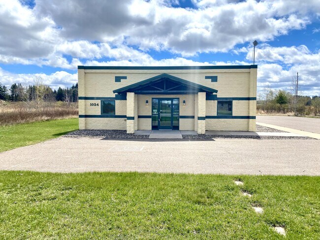
Property Record
1024 Thiesse Rd, Brainerd, MN 56401
NEARBY LISTINGS FOR SALE OR LEASE
-
-
View all Brainerd listings for lease on LoopNet.com
Property Detail
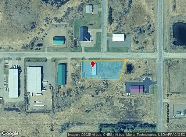
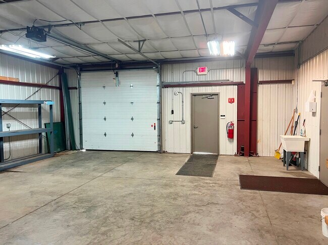
1024 Thiesse Rd
Brainerd, MN
Thiesse Industrial Park Addition
092440070060009
LOT 6 BLOCK 7
Commercialnec
Crow Wing
X
Minnesota
27035C0529C
6
2025
1.43 AC
2025
Minnesota Central Area
951100
Other Market Areas
2,448 SF
DEMOGRAPHICS near 1024 Thiesse Rd
1 Mile
3 Mile
5 Mile
2024 Total Population
983
12,648
22,541
2029 Population
1,033
13,167
23,480
Pop Growth 2024-2029
+ 5.09%
+ 4.10%
+ 4.17%
Average Age
43
39
39
2024 Total Households
393
5,346
9,170
HH Growth 2024-2029
+ 4.83%
+ 3.74%
+ 3.83%
Median Household Inc
$54,479
$49,752
$55,096
Avg Household Size
2.20
2.20
2.30
2024 Avg HH Vehicles
2.00
2.00
2.00
Median Home Value
$164,084
$157,559
$186,559
Median Year Built
1968
1972
1980
Nearby Places
Map Layers
Map Styles
 Street
 Aerial
- Restaurants
- Banks
- Shops
- Fitness
- Groceries
SALE & LEASE HISTORY
LISTING DATE
SALE/LEASE

Jan 24, 2024
For Lease
Jan 23, 2024
For Sale
Aug 22, 2024
For Lease
Aug 22, 2024
For Sale
Nearby Properties
Address
Land Use
TOTAL SIZE
Lot Size
Zoning
Address
Land Use
TOTAL SIZE
Lot Size
Zoning
320,708 SF
35.89 AC
Address
Land Use
TOTAL SIZE
Lot Size
Zoning
3,829 SF
1.04 AC
Address
Land Use
TOTAL SIZE
Lot Size
Zoning
186,000 SF
8.71 AC
Address
Land Use
TOTAL SIZE
Lot Size
Zoning
229,123 SF
11.84 AC
Address
Land Use
TOTAL SIZE
Lot Size
Zoning
128,295 SF
2.08 AC
Address
Land Use
TOTAL SIZE
Lot Size
Zoning
110,624 SF
5.62 AC
Address
Land Use
TOTAL SIZE
Lot Size
Zoning
33,460 SF
94.30 AC
Address
Land Use
TOTAL SIZE
Lot Size
Zoning
91,464 SF
4.83 AC
Address
Land Use
TOTAL SIZE
Lot Size
Zoning
61,704 SF
16.09 AC
Address
Land Use
TOTAL SIZE
Lot Size
Zoning
Address
Land Use
TOTAL SIZE
Lot Size
Zoning
25,104 SF
18.43 AC
Address
Land Use
TOTAL SIZE
Lot Size
Zoning
50,741 SF
13.48 AC
Address
Land Use
TOTAL SIZE
Lot Size
Zoning
113,024 SF
2.96 AC
Address
Land Use
TOTAL SIZE
Lot Size
Zoning
90,147 SF
12.93 AC
Address
Land Use
TOTAL SIZE
Lot Size
Zoning
55,953 SF
14.52 AC
Address
Land Use
TOTAL SIZE
Lot Size
Zoning
69,515 SF
2.14 AC
Address
Land Use
TOTAL SIZE
Lot Size
Zoning
68,675 SF
3.12 AC
Address
Land Use
TOTAL SIZE
Lot Size
Zoning
68,675 SF
3.06 AC
Address
Land Use
TOTAL SIZE
Lot Size
Zoning
54,164 SF
5.65 AC
Address
Land Use
TOTAL SIZE
Lot Size
Zoning
87,007 SF
4.98 AC
Address
Land Use
TOTAL SIZE
Lot Size
Zoning
66,967 SF
2.95 AC
Address
Land Use
TOTAL SIZE
Lot Size
Zoning
50,344 SF
12.62 AC
Address
Land Use
TOTAL SIZE
Lot Size
Zoning
68,564 SF
3.41 AC
Address
Land Use
TOTAL SIZE
Lot Size
Zoning
47,378 SF
1.56 AC
Address
Land Use
TOTAL SIZE
Lot Size
Zoning
844 SF
31.98 AC
Address
Land Use
TOTAL SIZE
Lot Size
Zoning
64,719 SF
2.06 AC
Address
Land Use
TOTAL SIZE
Lot Size
Zoning
64,719 SF
2.19 AC
Address
Land Use
TOTAL SIZE
Lot Size
Zoning
34,033 SF
9.81 AC
Address
Land Use
TOTAL SIZE
Lot Size
Zoning
100,000 SF
51.22 AC
Address
Land Use
TOTAL SIZE
Lot Size
Zoning
57,426 SF
2.61 AC
The World's #1 Commercial Real Estate Marketplace
Connect with us
© 2026 CoStar Group
The information above has been obtained from sources believed reliable. While we do not doubt its accuracy we have not verified it and make no guarantee, warranty or representation about it. It is your responsibility to independently confirm its accuracy and completeness. Any projections, opinions, assumptions, or estimates used are for example only and do not represent the current or future performance of the property. The value of this transaction to you depends on tax and other factors which should be evaluated by your tax, financial, and legal advisors. You and your advisors should conduct a careful, independent investigation of the property to determine to your satisfaction the suitability of the property for your needs.