No Photo
Property Record
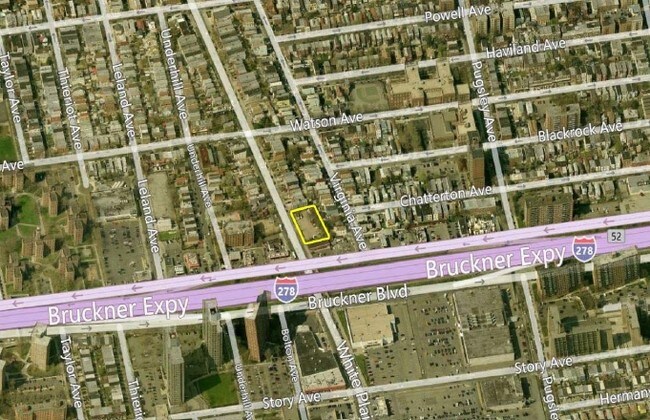
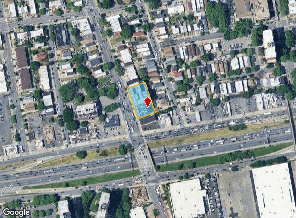
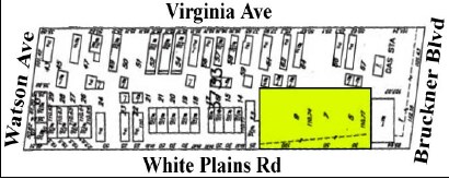
1024 White Plains Rd, Bronx, NY 10472
NEARBY LISTINGS FOR SALE OR LEASE
-
-
-
-
-
-
-
-
-
-
-
-
-
No Photo
-
-
View all Bronx listings for sale on LoopNet.com
Property Detail
1024 White Plains Rd
03733-0005
Map Of 185 Lots Estate Of Martin Schrenk
Publicschool
Bronx
X
New York
3604970103F
5
0
0.51 AC
2025
Bronx
006800
Westchester/So Connecticut
54,164 SF
New York-Jersey City-White Plains, NY-NJ
DEMOGRAPHICS near 1024 White Plains Rd
1 Mile
3 Mile
5 Mile
2024 Total Population
135,539
697,811
1,940,252
2029 Population
122,504
641,213
1,793,675
Pop Growth 2024-2029
(9.62%)
(8.11%)
(7.55%)
Average Age
38
37
39
2024 Total Households
47,226
240,581
704,658
HH Growth 2024-2029
(10.32%)
(8.91%)
(8.11%)
Median Household Inc
$43,942
$42,134
$46,596
Avg Household Size
2.80
2.70
2.60
2024 Avg HH Vehicles
1.00
1.00
1.00
Median Home Value
$512,172
$606,738
$583,940
Median Year Built
1951
1954
1952
Nearby Places
Map Layers
Map Styles
 Street
 Aerial
- Restaurants
- Banks
- Shops
- Fitness
- Groceries
PUBLIC TRANSPORTATION
TRANSIT/SUBWAY
Parkchester (6 - New York MTA Subway (The Subway))
DRIVE
WALK
Distance
Parkchester (6 - New York MTA Subway (The Subway))
4 min
10 min
0.5 mi
St Lawrence Avenue (6 - New York MTA Subway (The Subway))
DRIVE
WALK
Distance
St Lawrence Avenue (6 - New York MTA Subway (The Subway))
2 min
13 min
0.7 mi
Castle Hill Avenue (6 - New York MTA Subway (The Subway))
DRIVE
WALK
Distance
Castle Hill Avenue (6 - New York MTA Subway (The Subway))
3 min
19 min
1.0 mi
Morrison-Sound View Avenues (6 - New York MTA Subway (The Subway))
DRIVE
WALK
Distance
Morrison-Sound View Avenues (6 - New York MTA Subway (The Subway))
3 min
20 min
1.0 mi
COMMUTER RAIL
Tremont Station (Harlem Line - Metro-North Commuter Railroad Company (Metro-North))
DRIVE
WALK
Distance
Tremont Station (Harlem Line - Metro-North Commuter Railroad Company (Metro-North))
5 min
2.8 mi
Fordham Station (Harlem Line - Metro-North Commuter Railroad Company (Metro-North), New Haven Line - Metro-North Commuter Railroad Company (Metro-North))
DRIVE
WALK
Distance
Fordham Station (Harlem Line - Metro-North Commuter Railroad Company (Metro-North), New Haven Line - Metro-North Commuter Railroad Company (Metro-North))
8 min
4.1 mi
AIRPORT
LaGuardia
DRIVE
WALK
Distance
LaGuardia
17 min
8.9 mi
John F Kennedy International
DRIVE
WALK
Distance
John F Kennedy International
24 min
16.3 mi
Westchester County
DRIVE
WALK
Distance
Westchester County
36 min
23.6 mi
Freight Ports
NY - Red Hook Container Terminal
DRIVE
WALK
Distance
NY - Red Hook Container Terminal
30 min
17.1 mi
Nearby Properties
Address
Land Use
TOTAL SIZE
Lot Size
Zoning
Address
Land Use
TOTAL SIZE
Lot Size
Zoning
5,519,372 SF
409.21 AC
C8-2
Address
Land Use
TOTAL SIZE
Lot Size
Zoning
550,000 SF
8.75 AC
M1-1
Address
Land Use
TOTAL SIZE
Lot Size
Zoning
1,743,584 SF
77.87 AC
R6
Address
Land Use
TOTAL SIZE
Lot Size
Zoning
1,427,393 SF
39.94 AC
R4
Address
Land Use
TOTAL SIZE
Lot Size
Zoning
481,172 SF
205.58 AC
PARK
Address
Land Use
TOTAL SIZE
Lot Size
Zoning
5,000 SF
363.58 AC
PARK
Address
Land Use
TOTAL SIZE
Lot Size
Zoning
1,012,000 SF
7.79 AC
R6
Address
Land Use
TOTAL SIZE
Lot Size
Zoning
485,484 SF
39.63 AC
R5
Address
Land Use
TOTAL SIZE
Lot Size
Zoning
667,405 SF
5.51 AC
R6
Address
Land Use
TOTAL SIZE
Lot Size
Zoning
390,750 SF
265 AC
PARK
Address
Land Use
TOTAL SIZE
Lot Size
Zoning
480,769 SF
1.21 AC
R8
Address
Land Use
TOTAL SIZE
Lot Size
Zoning
851,821 SF
7.95 AC
R4
Address
Land Use
TOTAL SIZE
Lot Size
Zoning
426,172 SF
14.30 AC
M3-1
Address
Land Use
TOTAL SIZE
Lot Size
Zoning
491,007 SF
11.85 AC
M3-1
Address
Land Use
TOTAL SIZE
Lot Size
Zoning
14,681 SF
97 AC
PARK
Address
Land Use
TOTAL SIZE
Lot Size
Zoning
127,000 SF
16.53 AC
M3-1
Address
Land Use
TOTAL SIZE
Lot Size
Zoning
489,326 SF
19.18 AC
C8-1
Address
Land Use
TOTAL SIZE
Lot Size
Zoning
224,037 SF
0.82 AC
C45X
Address
Land Use
TOTAL SIZE
Lot Size
Zoning
361,354 SF
C4-2
Address
Land Use
TOTAL SIZE
Lot Size
Zoning
1,172,005 SF
128.83 AC
M1-1
Address
Land Use
TOTAL SIZE
Lot Size
Zoning
510 SF
68.73 AC
PARK
Address
Land Use
TOTAL SIZE
Lot Size
Zoning
601,260 SF
3.27 AC
R4
Address
Land Use
TOTAL SIZE
Lot Size
Zoning
406,549 SF
3.22 AC
C4-4
Address
Land Use
TOTAL SIZE
Lot Size
Zoning
450,879 SF
9.10 AC
M1-1
Address
Land Use
TOTAL SIZE
Lot Size
Zoning
450,000 SF
5.59 AC
R6
Address
Land Use
TOTAL SIZE
Lot Size
Zoning
726,051 SF
33.66 AC
R5
Address
Land Use
TOTAL SIZE
Lot Size
Zoning
274,840 SF
2.80 AC
M1-1
Address
Land Use
TOTAL SIZE
Lot Size
Zoning
312,844 SF
0.44 AC
M14R7X
Address
Land Use
TOTAL SIZE
Lot Size
Zoning
674,889 SF
51.55 AC
M3-1
Address
Land Use
TOTAL SIZE
Lot Size
Zoning
140,000 SF
2.34 AC
M1-4
The World's #1 Commercial Real Estate Marketplace
Connect with us
© 2026 CoStar Group
The information above has been obtained from sources believed reliable. While we do not doubt its accuracy we have not verified it and make no guarantee, warranty or representation about it. It is your responsibility to independently confirm its accuracy and completeness. Any projections, opinions, assumptions, or estimates used are for example only and do not represent the current or future performance of the property. The value of this transaction to you depends on tax and other factors which should be evaluated by your tax, financial, and legal advisors. You and your advisors should conduct a careful, independent investigation of the property to determine to your satisfaction the suitability of the property for your needs.