Property Record
10241 Lewis And Clark Blvd, Saint Louis, MO 63136
NEARBY LISTINGS FOR SALE OR LEASE
Property Detail
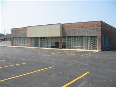
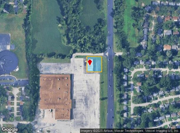
10241 Lewis And Clark Blvd
St. Louis, MO-IL
Hunter Glick
11F-54-0472
HUNTER GLICK LOT 1
Medicalbuilding
St. Louis
X
Missouri
29183C0350G
1
2024
0.52 AC
2025
Northwest County
210501
St. Louis
7,333 SF
DEMOGRAPHICS near 10241 Lewis And Clark Blvd
1 Mile
3 Mile
5 Mile
2024 Total Population
11,775
94,747
191,136
2029 Population
11,781
94,506
190,289
Pop Growth 2024-2029
+ 0.05%
(0.25%)
(0.44%)
Average Age
39
38
39
2024 Total Households
4,378
38,030
76,891
HH Growth 2024-2029
(0.07%)
(0.39%)
(0.50%)
Median Household Inc
$40,936
$39,704
$42,352
Avg Household Size
2.50
2.40
2.40
2024 Avg HH Vehicles
1.00
1.00
1.00
Median Home Value
$73,670
$87,029
$97,399
Median Year Built
1957
1961
1959
Nearby Places
Map Layers
Map Styles
 Street
 Aerial
- Restaurants
- Banks
- Shops
- Fitness
- Groceries
PUBLIC TRANSPORTATION
COMMUTER RAIL
UM St. Louis South (Lambert Airport Shiloh-Scott - St. Louis MetroLink (MetroLink))
DRIVE
WALK
Distance
UM St. Louis South (Lambert Airport Shiloh-Scott - St. Louis MetroLink (MetroLink))
13 min
6.5 mi
UM St. Louis North (Lambert Airport Shiloh-Scott - St. Louis MetroLink (MetroLink))
DRIVE
WALK
Distance
UM St. Louis North (Lambert Airport Shiloh-Scott - St. Louis MetroLink (MetroLink))
13 min
6.9 mi
AIRPORT
St Louis Lambert International
DRIVE
WALK
Distance
St Louis Lambert International
13 min
7.0 mi
Scott AFB/Midamerica St Louis
DRIVE
WALK
Distance
Scott AFB/Midamerica St Louis
53 min
33.9 mi
Nearby Properties
Address
Land Use
TOTAL SIZE
Lot Size
Zoning
Address
Land Use
TOTAL SIZE
Lot Size
Zoning
1,925 SF
21.27 AC
C-8
Address
Land Use
TOTAL SIZE
Lot Size
Zoning
75.13 AC
R3
Address
Land Use
TOTAL SIZE
Lot Size
Zoning
25,545 SF
82.84 AC
R1B
Address
Land Use
TOTAL SIZE
Lot Size
Zoning
205,268 SF
36.09 AC
88R-1
Address
Land Use
TOTAL SIZE
Lot Size
Zoning
48.23 AC
R3
Address
Land Use
TOTAL SIZE
Lot Size
Zoning
643,294 SF
32.09 AC
R7
Address
Land Use
TOTAL SIZE
Lot Size
Zoning
39.86 AC
A
Address
Land Use
TOTAL SIZE
Lot Size
Zoning
293,117 SF
26 AC
R3
Address
Land Use
TOTAL SIZE
Lot Size
Zoning
58,818 SF
8.02 AC
22C-1
Address
Land Use
TOTAL SIZE
Lot Size
Zoning
47,184 SF
119.33 AC
PS
Address
Land Use
TOTAL SIZE
Lot Size
Zoning
15.59 AC
R4
Address
Land Use
TOTAL SIZE
Lot Size
Zoning
77,616 SF
10.56 AC
C-8
Address
Land Use
TOTAL SIZE
Lot Size
Zoning
448,714 SF
34.05 AC
22M-1
Address
Land Use
TOTAL SIZE
Lot Size
Zoning
148,974 SF
17.04 AC
C-8
Address
Land Use
TOTAL SIZE
Lot Size
Zoning
20.62 AC
R3
Address
Land Use
TOTAL SIZE
Lot Size
Zoning
108,753 SF
18.44 AC
31C-3
Address
Land Use
TOTAL SIZE
Lot Size
Zoning
18.86 AC
R3
Address
Land Use
TOTAL SIZE
Lot Size
Zoning
1.80 AC
31R-1
Address
Land Use
TOTAL SIZE
Lot Size
Zoning
39,462 SF
8.64 AC
22C-2
Address
Land Use
TOTAL SIZE
Lot Size
Zoning
218,822 SF
15.94 AC
R6
Address
Land Use
TOTAL SIZE
Lot Size
Zoning
10,362 SF
19.03 AC
81R-2
Address
Land Use
TOTAL SIZE
Lot Size
Zoning
176,771 SF
21.24 AC
C-8
Address
Land Use
TOTAL SIZE
Lot Size
Zoning
179,262 SF
9.58 AC
R2
Address
Land Use
TOTAL SIZE
Lot Size
Zoning
1.58 AC
22R-1B
Address
Land Use
TOTAL SIZE
Lot Size
Zoning
10 AC
R3
Address
Land Use
TOTAL SIZE
Lot Size
Zoning
166,364 SF
37.42 AC
C-8
Address
Land Use
TOTAL SIZE
Lot Size
Zoning
120.20 AC
PS
Address
Land Use
TOTAL SIZE
Lot Size
Zoning
64,372 SF
4.95 AC
C-8
Address
Land Use
TOTAL SIZE
Lot Size
Zoning
8.66 AC
R3
Address
Land Use
TOTAL SIZE
Lot Size
Zoning
132,428 SF
12.71 AC
22C-2
The World's #1 Commercial Real Estate Marketplace
Connect with us
© 2025 CoStar Group
The information above has been obtained from sources believed reliable. While we do not doubt its accuracy we have not verified it and make no guarantee, warranty or representation about it. It is your responsibility to independently confirm its accuracy and completeness. Any projections, opinions, assumptions, or estimates used are for example only and do not represent the current or future performance of the property. The value of this transaction to you depends on tax and other factors which should be evaluated by your tax, financial, and legal advisors. You and your advisors should conduct a careful, independent investigation of the property to determine to your satisfaction the suitability of the property for your needs.