Property Record
1025 44Th Ave, Oakland, CA 94601
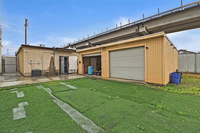

This Property Is For Sale
NEARBY LISTINGS FOR SALE OR LEASE
Property Detail
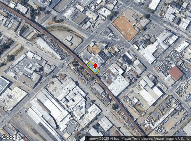
1025 44Th Ave
Oakland-Hayward-Berkeley, CA
Huntington
034-2264-009-02
LOT: 00002 BLK: 0009 AR: 0034 PAGE: 2264
Warehouse
Alameda
X
California
06001C0089H
15
2024
0.14 AC
2025
Oakland
407300
East Bay/Oakland
1,779 SF
DEMOGRAPHICS near 1025 44Th Ave
1 Mile
3 Mile
5 Mile
2024 Total Population
34,666
263,278
487,276
2029 Population
33,312
254,134
472,667
Pop Growth 2024-2029
(3.91%)
(3.47%)
(3.00%)
Average Age
37
40
41
2024 Total Households
10,013
91,828
184,621
HH Growth 2024-2029
(4.10%)
(3.63%)
(3.03%)
Median Household Inc
$59,923
$82,027
$90,363
Avg Household Size
3.10
2.70
2.50
2024 Avg HH Vehicles
2.00
2.00
2.00
Median Home Value
$693,994
$861,011
$910,530
Median Year Built
1948
1949
1955
Nearby Places
- Restaurants
- Banks
- Shops
- Fitness
- Groceries
PUBLIC TRANSPORTATION
TRANSIT/SUBWAY
Fruitvale Station (Berryessa/North San Jose to Daly City - Bay Area Rapid Transit (BART), Berryessa/North San Jose to Richmond - Bay Area Rapid Transit (BART), Daly City to Berryessa/North San Jose - Bay Area Rapid Transit (BART), Daly City to Dublin/Pleasanton - Bay Area Rapid Transit (BART), Dublin/Pleasanton - Millbrae - Bay Area Rapid Transit (BART), Fremont - Daly City - Bay Area Rapid Transit (BART), Fremont - Richmond - Bay Area Rapid Transit (BART), Richmond to Berryessa/North San Jose - Bay Area Rapid Transit (BART))
DRIVE
WALK
Distance
Fruitvale Station (Berryessa/North San Jose to Daly City - Bay Area Rapid Transit (BART), Berryessa/North San Jose to Richmond - Bay Area Rapid Transit (BART), Daly City to Berryessa/North San Jose - Bay Area Rapid Transit (BART), Daly City to Dublin/Pleasanton - Bay Area Rapid Transit (BART), Dublin/Pleasanton - Millbrae - Bay Area Rapid Transit (BART), Fremont - Daly City - Bay Area Rapid Transit (BART), Fremont - Richmond - Bay Area Rapid Transit (BART), Richmond to Berryessa/North San Jose - Bay Area Rapid Transit (BART))
2 min
11 min
0.6 mi
COMMUTER RAIL
Oakland (Capitol Corridor - Amtrak, Coast Starlight - Amtrak, San Joaquins - Amtrak)
DRIVE
WALK
Distance
Oakland (Capitol Corridor - Amtrak, Coast Starlight - Amtrak, San Joaquins - Amtrak)
7 min
4.1 mi
Emeryville (California Zephyr - Amtrak, Capitol Corridor - Amtrak, Coast Starlight - Amtrak, San Joaquins - Amtrak)
DRIVE
WALK
Distance
Emeryville (California Zephyr - Amtrak, Capitol Corridor - Amtrak, Coast Starlight - Amtrak, San Joaquins - Amtrak)
14 min
9.3 mi
AIRPORT
Metro Oakland International
DRIVE
WALK
Distance
Metro Oakland International
9 min
5.6 mi
San Francisco International
DRIVE
WALK
Distance
San Francisco International
41 min
27.4 mi
Freight Ports
Port of Oakland
DRIVE
WALK
Distance
Port of Oakland
8 min
4.6 mi
Nearby Properties
Address
Land Use
TOTAL SIZE
Lot Size
Zoning
Address
Land Use
TOTAL SIZE
Lot Size
Zoning
Address
Land Use
TOTAL SIZE
Lot Size
Zoning
546,164 SF
6.02 AC
Address
Land Use
TOTAL SIZE
Lot Size
Zoning
371,504 SF
4.08 AC
Address
Land Use
TOTAL SIZE
Lot Size
Zoning
534,208 SF
23.18 AC
Address
Land Use
TOTAL SIZE
Lot Size
Zoning
273,623 SF
1.44 AC
Address
Land Use
TOTAL SIZE
Lot Size
Zoning
297,617 SF
1.54 AC
Address
Land Use
TOTAL SIZE
Lot Size
Zoning
259,247 SF
5.44 AC
R5PD
Address
Land Use
TOTAL SIZE
Lot Size
Zoning
525,864 SF
16.53 AC
Address
Land Use
TOTAL SIZE
Lot Size
Zoning
180,959 SF
9.38 AC
Address
Land Use
TOTAL SIZE
Lot Size
Zoning
374,725 SF
18.63 AC
Address
Land Use
TOTAL SIZE
Lot Size
Zoning
336,680 SF
9.93 AC
M40
Address
Land Use
TOTAL SIZE
Lot Size
Zoning
133,636 SF
5.46 AC
Address
Land Use
TOTAL SIZE
Lot Size
Zoning
284,255 SF
5.07 AC
Address
Land Use
TOTAL SIZE
Lot Size
Zoning
320,001 SF
37.56 AC
Address
Land Use
TOTAL SIZE
Lot Size
Zoning
165,042 SF
13.50 AC
Address
Land Use
TOTAL SIZE
Lot Size
Zoning
169,558 SF
1.65 AC
Address
Land Use
TOTAL SIZE
Lot Size
Zoning
200,238 SF
9.28 AC
Address
Land Use
TOTAL SIZE
Lot Size
Zoning
10.96 AC
Address
Land Use
TOTAL SIZE
Lot Size
Zoning
Address
Land Use
TOTAL SIZE
Lot Size
Zoning
133,678 SF
4.33 AC
Address
Land Use
TOTAL SIZE
Lot Size
Zoning
155,000 SF
8.41 AC
Address
Land Use
TOTAL SIZE
Lot Size
Zoning
136,127 SF
8.21 AC
Address
Land Use
TOTAL SIZE
Lot Size
Zoning
232,068 SF
31.82 AC
Address
Land Use
TOTAL SIZE
Lot Size
Zoning
129,726 SF
5.38 AC
Address
Land Use
TOTAL SIZE
Lot Size
Zoning
0.94 AC
Address
Land Use
TOTAL SIZE
Lot Size
Zoning
197,321 SF
16.52 AC
Address
Land Use
TOTAL SIZE
Lot Size
Zoning
213,600 SF
10.60 AC
Address
Land Use
TOTAL SIZE
Lot Size
Zoning
1,189,534 SF
26.64 AC
Address
Land Use
TOTAL SIZE
Lot Size
Zoning
204,006 SF
6.39 AC
M40
Address
Land Use
TOTAL SIZE
Lot Size
Zoning
148,380 SF
12.33 AC
The World's #1 Commercial Real Estate Marketplace
Connect with us
© 2025 CoStar Group
The information above has been obtained from sources believed reliable. While we do not doubt its accuracy we have not verified it and make no guarantee, warranty or representation about it. It is your responsibility to independently confirm its accuracy and completeness. Any projections, opinions, assumptions, or estimates used are for example only and do not represent the current or future performance of the property. The value of this transaction to you depends on tax and other factors which should be evaluated by your tax, financial, and legal advisors. You and your advisors should conduct a careful, independent investigation of the property to determine to your satisfaction the suitability of the property for your needs.