Property Record
1025 Highway 36, Millstone Twp, NJ 07716

NEARBY LISTINGS FOR SALE OR LEASE
-
-
View all Millstone Twp listings for sale on LoopNet.com
Property Detail
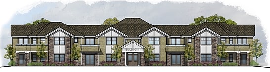
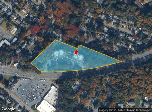
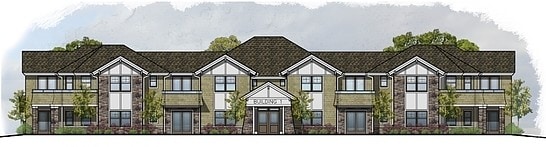
1025 Highway 36
32-00732-0000-00010-01
Monmouth
Apartment
New Jersey
X
10.1
34025C0069G
5.32 AC
2024
Aberdeen/Hazlet/Middletown
2025
Northern New Jersey
800900
Lakewood-New Brunswick, NJ
DEMOGRAPHICS near 1025 Highway 36
1 Mile
3 Mile
5 Mile
2024 Total Population
6,664
27,034
78,260
2029 Population
6,627
27,223
78,194
Pop Growth 2024-2029
(0.56%)
+ 0.70%
(0.08%)
Average Age
46
44
43
2024 Total Households
2,918
11,092
30,535
HH Growth 2024-2029
(0.93%)
+ 0.93%
(0.03%)
Median Household Inc
$113,912
$128,644
$130,542
Avg Household Size
2.30
2.40
2.50
2024 Avg HH Vehicles
2.00
2.00
2.00
Median Home Value
$644,984
$582,001
$572,585
Median Year Built
1965
1964
1963
Nearby Places
Map Layers
Map Styles
 Street
 Aerial
- Restaurants
- Banks
- Shops
- Fitness
- Groceries
PUBLIC TRANSPORTATION
COMMUTER RAIL
Middletown Nj (North Jersey Coast Line - NJ TRANSIT RAIL)
DRIVE
WALK
Distance
Middletown Nj (North Jersey Coast Line - NJ TRANSIT RAIL)
12 min
7.0 mi
Red Bank (North Jersey Coast Line - NJ Transit Commuter Rail (NJ Transit))
DRIVE
WALK
Distance
Red Bank (North Jersey Coast Line - NJ Transit Commuter Rail (NJ Transit))
13 min
7.1 mi
AIRPORT
Newark Liberty International
DRIVE
WALK
Distance
Newark Liberty International
50 min
37.8 mi
Freight Ports
New York Container Terminal
DRIVE
WALK
Distance
New York Container Terminal
43 min
32.9 mi
Nearby Properties
Address
Land Use
TOTAL SIZE
Lot Size
Zoning
Address
Land Use
TOTAL SIZE
Lot Size
Zoning
596.51 AC
FL
Address
Land Use
TOTAL SIZE
Lot Size
Zoning
167,221 SF
18.74 AC
POS
Address
Land Use
TOTAL SIZE
Lot Size
Zoning
35.84 AC
R-22
Address
Land Use
TOTAL SIZE
Lot Size
Zoning
47,470 SF
15.43 AC
POS
Address
Land Use
TOTAL SIZE
Lot Size
Zoning
37 AC
H-BP
Address
Land Use
TOTAL SIZE
Lot Size
Zoning
77,396 SF
11.47 AC
R-22
Address
Land Use
TOTAL SIZE
Lot Size
Zoning
1,800 SF
504.53 AC
R220
Address
Land Use
TOTAL SIZE
Lot Size
Zoning
72,355 SF
11.72 AC
R-1
Address
Land Use
TOTAL SIZE
Lot Size
Zoning
96.54 AC
FL
Address
Land Use
TOTAL SIZE
Lot Size
Zoning
163,312 SF
16.21 AC
PRH
Address
Land Use
TOTAL SIZE
Lot Size
Zoning
15,866 SF
4.85 AC
POS
Address
Land Use
TOTAL SIZE
Lot Size
Zoning
50,339 SF
10.50 AC
B-3
Address
Land Use
TOTAL SIZE
Lot Size
Zoning
40,119 SF
48.25 AC
R220
Address
Land Use
TOTAL SIZE
Lot Size
Zoning
178 AC
R220
Address
Land Use
TOTAL SIZE
Lot Size
Zoning
10,635 SF
1.15 AC
R110
Address
Land Use
TOTAL SIZE
Lot Size
Zoning
162.89 AC
R220
Address
Land Use
TOTAL SIZE
Lot Size
Zoning
1.77 AC
MF-2
Address
Land Use
TOTAL SIZE
Lot Size
Zoning
23,090 SF
11.21 AC
MR
Address
Land Use
TOTAL SIZE
Lot Size
Zoning
4,000 SF
67.50 AC
R110
Address
Land Use
TOTAL SIZE
Lot Size
Zoning
74,620 SF
0.87 AC
MF
Address
Land Use
TOTAL SIZE
Lot Size
Zoning
17,200 SF
8.37 AC
SF80
Address
Land Use
TOTAL SIZE
Lot Size
Zoning
2,161 SF
95.96 AC
R220
Address
Land Use
TOTAL SIZE
Lot Size
Zoning
93,620 SF
12.03 AC
R102
Address
Land Use
TOTAL SIZE
Lot Size
Zoning
6,168 SF
13.09 AC
Address
Land Use
TOTAL SIZE
Lot Size
Zoning
21,208 SF
1.14 AC
R110
Address
Land Use
TOTAL SIZE
Lot Size
Zoning
23,778 SF
1.55 AC
SF0
Address
Land Use
TOTAL SIZE
Lot Size
Zoning
1,980 SF
10.20 AC
MR
Address
Land Use
TOTAL SIZE
Lot Size
Zoning
48,256 SF
87 SF
R-1
Address
Land Use
TOTAL SIZE
Lot Size
Zoning
44,755 SF
0.01 AC
B-3
Address
Land Use
TOTAL SIZE
Lot Size
Zoning
33,784 SF
6.55 AC
R203
The World's #1 Commercial Real Estate Marketplace
Connect with us
© 2026 CoStar Group
The information above has been obtained from sources believed reliable. While we do not doubt its accuracy we have not verified it and make no guarantee, warranty or representation about it. It is your responsibility to independently confirm its accuracy and completeness. Any projections, opinions, assumptions, or estimates used are for example only and do not represent the current or future performance of the property. The value of this transaction to you depends on tax and other factors which should be evaluated by your tax, financial, and legal advisors. You and your advisors should conduct a careful, independent investigation of the property to determine to your satisfaction the suitability of the property for your needs.