Property Record
1025 Magnolia Bluff Way Sw, Darien, GA 31305
NEARBY LISTINGS FOR SALE OR LEASE
Property Detail
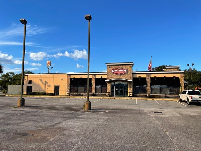
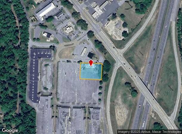
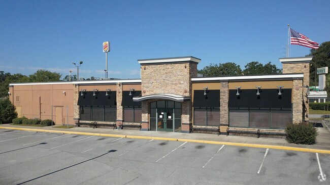
1025 Magnolia Bluff Way Sw
0040-0017017
Comm-I95 Hwy 251
Restaurantbuilding
.99 ACS MAGNOLIA BLUFF OUTLET MALL-RUBY TUES
X
Mcintosh
13191C0289E
Georgia
2024
0.99 AC
2024
Brunswick/Kingsland
110300
Other Market Areas
5,610 SF
Brunswick-St. Simons, GA
DEMOGRAPHICS near 1025 Magnolia Bluff Way Sw
1 Mile
3 Mile
5 Mile
2024 Total Population
103
3,240
4,141
2029 Population
105
3,328
4,240
Pop Growth 2024-2029
+ 1.94%
+ 2.72%
+ 2.39%
Average Age
45
45
45
2024 Total Households
42
1,361
1,743
HH Growth 2024-2029
+ 2.38%
+ 2.42%
+ 2.12%
Median Household Inc
$34,999
$44,361
$44,314
Avg Household Size
2.30
2.30
2.30
2024 Avg HH Vehicles
2.00
2.00
2.00
Median Home Value
$177,777
$179,821
$182,903
Median Year Built
1994
1992
1992
Nearby Places
Map Layers
Map Styles
 Street
 Aerial
- Restaurants
- Banks
- Shops
- Fitness
- Groceries
PUBLIC TRANSPORTATION
AIRPORT
Brunswick Golden Isles
DRIVE
WALK
Distance
Brunswick Golden Isles
21 min
13.9 mi
Freight Ports
Georgia Ports - Brunswick
DRIVE
WALK
Distance
Georgia Ports - Brunswick
33 min
23.9 mi
SALE & LEASE HISTORY
LISTING DATE
SALE/LEASE

Oct 05, 2018
For Sale
Nov 03, 2021
For Sale
Apr 28, 2025
For Sale
Nearby Properties
Address
Land Use
TOTAL SIZE
Lot Size
Zoning
Address
Land Use
TOTAL SIZE
Lot Size
Zoning
48,252 SF
1.72 AC
C-2
Address
Land Use
TOTAL SIZE
Lot Size
Zoning
13,888 SF
42.19 AC
002
Address
Land Use
TOTAL SIZE
Lot Size
Zoning
35,154 SF
1.65 AC
001
Address
Land Use
TOTAL SIZE
Lot Size
Zoning
1,972 SF
8.87 AC
R-2
Address
Land Use
TOTAL SIZE
Lot Size
Zoning
32,500 SF
1.50 AC
002
Address
Land Use
TOTAL SIZE
Lot Size
Zoning
26,520 SF
1.50 AC
C-I
Address
Land Use
TOTAL SIZE
Lot Size
Zoning
20,690 SF
0.78 AC
C-I
Address
Land Use
TOTAL SIZE
Lot Size
Zoning
13,331 SF
2.52 AC
001
Address
Land Use
TOTAL SIZE
Lot Size
Zoning
15,120 SF
3.95 AC
007
Address
Land Use
TOTAL SIZE
Lot Size
Zoning
17,760 SF
9.43 AC
002
Address
Land Use
TOTAL SIZE
Lot Size
Zoning
5,550 SF
10.92 AC
002
Address
Land Use
TOTAL SIZE
Lot Size
Zoning
47,766 SF
12.36 AC
002
Address
Land Use
TOTAL SIZE
Lot Size
Zoning
2,016 SF
58.62 AC
007
Address
Land Use
TOTAL SIZE
Lot Size
Zoning
26,148 SF
3.75 AC
98BP
Address
Land Use
TOTAL SIZE
Lot Size
Zoning
1,148 SF
3.30 AC
99BP
Address
Land Use
TOTAL SIZE
Lot Size
Zoning
2,400 SF
3.22 AC
01BP
Address
Land Use
TOTAL SIZE
Lot Size
Zoning
11,232 SF
3.99 AC
001
Address
Land Use
TOTAL SIZE
Lot Size
Zoning
14,700 SF
10.60 AC
001
Address
Land Use
TOTAL SIZE
Lot Size
Zoning
3,040 SF
1.51 AC
007
Address
Land Use
TOTAL SIZE
Lot Size
Zoning
23,129 SF
3.15 AC
001
Address
Land Use
TOTAL SIZE
Lot Size
Zoning
14.86 AC
001
Address
Land Use
TOTAL SIZE
Lot Size
Zoning
8,472 SF
1.77 AC
001
Address
Land Use
TOTAL SIZE
Lot Size
Zoning
3,192 SF
0.99 AC
001
Address
Land Use
TOTAL SIZE
Lot Size
Zoning
0.49 AC
C-2
Address
Land Use
TOTAL SIZE
Lot Size
Zoning
3,384 SF
1.75 AC
002
Address
Land Use
TOTAL SIZE
Lot Size
Zoning
463.26 AC
002
Address
Land Use
TOTAL SIZE
Lot Size
Zoning
4,920 SF
0.55 AC
001
Address
Land Use
TOTAL SIZE
Lot Size
Zoning
4,065 SF
1 AC
C-I
Address
Land Use
TOTAL SIZE
Lot Size
Zoning
5,625 SF
1.21 AC
99BP
Address
Land Use
TOTAL SIZE
Lot Size
Zoning
0.76 AC
001
The World's #1 Commercial Real Estate Marketplace
Connect with us
© 2026 CoStar Group
The information above has been obtained from sources believed reliable. While we do not doubt its accuracy we have not verified it and make no guarantee, warranty or representation about it. It is your responsibility to independently confirm its accuracy and completeness. Any projections, opinions, assumptions, or estimates used are for example only and do not represent the current or future performance of the property. The value of this transaction to you depends on tax and other factors which should be evaluated by your tax, financial, and legal advisors. You and your advisors should conduct a careful, independent investigation of the property to determine to your satisfaction the suitability of the property for your needs.