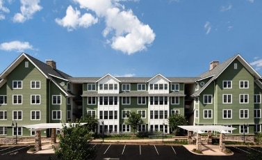
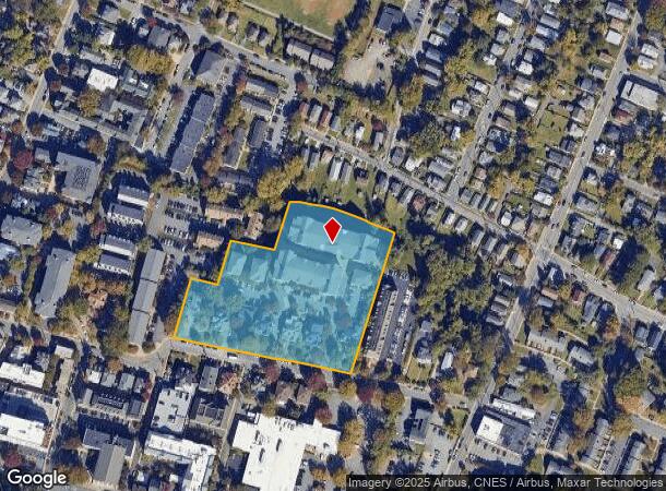
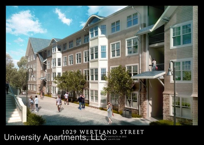
Property Record
1025 Wertland St, Charlottesville, VA 22903
NEARBY LISTINGS FOR SALE OR LEASE
Property Detail
1025 Wertland St
Charlottesville, VA
Apartments
040-305-000
LOTS C & D
Apartmenthouse5plusunits
Charlottesville
X
Virginia
51003C0286D
c,d
0
4.27 AC
2025
Venable
000202
Other Market Areas
5,136 SF
DEMOGRAPHICS near 1025 Wertland St
1 Mile
3 Mile
5 Mile
2024 Total Population
22,661
81,819
100,018
2029 Population
22,263
82,093
101,065
Pop Growth 2024-2029
(1.76%)
+ 0.33%
+ 1.05%
Average Age
30
36
37
2024 Total Households
8,218
33,170
40,566
HH Growth 2024-2029
(2.13%)
+ 0.39%
+ 1.17%
Median Household Inc
$48,807
$70,166
$75,390
Avg Household Size
2.20
2.10
2.20
2024 Avg HH Vehicles
1.00
2.00
2.00
Median Home Value
$424,738
$388,783
$406,496
Median Year Built
1972
1982
1984
Nearby Places
Map Layers
Map Styles
 Street
 Aerial
- Restaurants
- Banks
- Shops
- Fitness
- Groceries
PUBLIC TRANSPORTATION
COMMUTER RAIL
Charlottesville (Cardinal - Amtrak, Crescent - Amtrak, Northeast Regional - Amtrak)
DRIVE
WALK
Distance
Charlottesville (Cardinal - Amtrak, Crescent - Amtrak, Northeast Regional - Amtrak)
3 min
8 min
0.5 mi
AIRPORT
Charlottesville-Albemarle
DRIVE
WALK
Distance
Charlottesville-Albemarle
21 min
9.8 mi
Freight Ports
Virginia Port Authority - Richmond
DRIVE
WALK
Distance
Virginia Port Authority - Richmond
96 min
79.0 mi
Nearby Properties
Address
Land Use
TOTAL SIZE
Lot Size
Zoning
Address
Land Use
TOTAL SIZE
Lot Size
Zoning
872,960 SF
20.90 AC
CM
Address
Land Use
TOTAL SIZE
Lot Size
Zoning
5,672 SF
24.90 AC
RURAL AREA
Address
Land Use
TOTAL SIZE
Lot Size
Zoning
45 AC
RURAL AREA
Address
Land Use
TOTAL SIZE
Lot Size
Zoning
13,125 SF
100.40 AC
R1 RESIDEN
Address
Land Use
TOTAL SIZE
Lot Size
Zoning
61,177 SF
30.40 AC
R1 RESIDEN
Address
Land Use
TOTAL SIZE
Lot Size
Zoning
429,500 SF
38.49 AC
PDMC
Address
Land Use
TOTAL SIZE
Lot Size
Zoning
15 AC
RURAL AREA
Address
Land Use
TOTAL SIZE
Lot Size
Zoning
34.70 AC
RURAL AREA
Address
Land Use
TOTAL SIZE
Lot Size
Zoning
167,708 SF
1.05 AC
CM
Address
Land Use
TOTAL SIZE
Lot Size
Zoning
250 SF
44.20 AC
RURAL AREA
Address
Land Use
TOTAL SIZE
Lot Size
Zoning
165,360 SF
25.70 AC
RURAL AREA
Address
Land Use
TOTAL SIZE
Lot Size
Zoning
497,658 SF
39.83 AC
NX-10
Address
Land Use
TOTAL SIZE
Lot Size
Zoning
3,465 SF
145.17 AC
CV
Address
Land Use
TOTAL SIZE
Lot Size
Zoning
254,749 SF
80.72 AC
CM
Address
Land Use
TOTAL SIZE
Lot Size
Zoning
45,873 SF
30 AC
RURAL AREA
Address
Land Use
TOTAL SIZE
Lot Size
Zoning
101,778 SF
11.11 AC
CM
Address
Land Use
TOTAL SIZE
Lot Size
Zoning
99,841 SF
47.68 AC
PLANNED DE
Address
Land Use
TOTAL SIZE
Lot Size
Zoning
62,900 SF
4.71 AC
NX-10
Address
Land Use
TOTAL SIZE
Lot Size
Zoning
3,803 SF
266.70 AC
CV
Address
Land Use
TOTAL SIZE
Lot Size
Zoning
12,180 SF
26.20 AC
RURAL AREA
Address
Land Use
TOTAL SIZE
Lot Size
Zoning
578,208 SF
2.06 AC
CX-8
Address
Land Use
TOTAL SIZE
Lot Size
Zoning
43,616 SF
2.24 AC
CX-8
Address
Land Use
TOTAL SIZE
Lot Size
Zoning
983 SF
0.39 AC
CM
Address
Land Use
TOTAL SIZE
Lot Size
Zoning
10,270 SF
3.59 AC
RX-5
Address
Land Use
TOTAL SIZE
Lot Size
Zoning
12,876 SF
32.70 AC
NEIGHBORHO
Address
Land Use
TOTAL SIZE
Lot Size
Zoning
250,632 SF
1.79 AC
CM
Address
Land Use
TOTAL SIZE
Lot Size
Zoning
393,960 SF
16.14 AC
NMD
Address
Land Use
TOTAL SIZE
Lot Size
Zoning
30,896 SF
0.97 AC
DX
Address
Land Use
TOTAL SIZE
Lot Size
Zoning
78,332 SF
33.82 AC
CM
Address
Land Use
TOTAL SIZE
Lot Size
Zoning
240,936 SF
1.26 AC
NX-10
The World's #1 Commercial Real Estate Marketplace
Connect with us
© 2025 CoStar Group
The information above has been obtained from sources believed reliable. While we do not doubt its accuracy we have not verified it and make no guarantee, warranty or representation about it. It is your responsibility to independently confirm its accuracy and completeness. Any projections, opinions, assumptions, or estimates used are for example only and do not represent the current or future performance of the property. The value of this transaction to you depends on tax and other factors which should be evaluated by your tax, financial, and legal advisors. You and your advisors should conduct a careful, independent investigation of the property to determine to your satisfaction the suitability of the property for your needs.