Property Record
10255 Archer Dr, Brownsburg, IN 46112
NEARBY LISTINGS FOR SALE OR LEASE
Property Detail
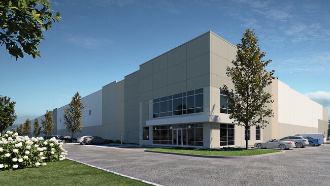
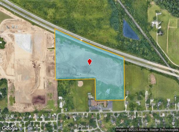
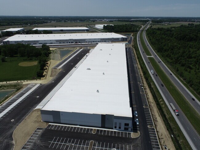
10255 Archer Dr
Indianapolis-Carmel-Anderson, IN
EAGLE CREEK LOGISTICS PARK LOT-2 29.46AC
32-08-17-210-002.000-016
Hendricks
Warehouse
Indiana
2024
29.46 AC
2024
West Hendricks Cty
210109
Indianapolis
DEMOGRAPHICS near 10255 Archer Dr
1 Mile
3 Mile
5 Mile
2024 Total Population
3,423
47,469
155,546
2029 Population
3,767
50,774
162,474
Pop Growth 2024-2029
+ 10.05%
+ 6.96%
+ 4.45%
Average Age
37
38
37
2024 Total Households
1,245
18,553
59,675
HH Growth 2024-2029
+ 9.96%
+ 6.21%
+ 4.07%
Median Household Inc
$96,921
$83,841
$73,509
Avg Household Size
2.70
2.50
2.50
2024 Avg HH Vehicles
2.00
2.00
2.00
Median Home Value
$188,183
$213,053
$205,194
Median Year Built
2003
1994
1990
Nearby Places
Map Layers
Map Styles
 Street
 Aerial
- Restaurants
- Banks
- Shops
- Fitness
- Groceries
PUBLIC TRANSPORTATION
AIRPORT
Indianapolis International
DRIVE
WALK
Distance
Indianapolis International
27 min
15.8 mi
Freight Ports
Port of Toledo
DRIVE
WALK
Distance
Port of Toledo
282 min
233.3 mi
SALE & LEASE HISTORY
LISTING DATE
SALE/LEASE

Jan 19, 2022
For Lease
Nearby Properties
Address
Land Use
TOTAL SIZE
Lot Size
Zoning
Address
Land Use
TOTAL SIZE
Lot Size
Zoning
56.57 AC
Address
Land Use
TOTAL SIZE
Lot Size
Zoning
805,018 SF
48.20 AC
Address
Land Use
TOTAL SIZE
Lot Size
Zoning
683,528 SF
43.54 AC
Address
Land Use
TOTAL SIZE
Lot Size
Zoning
773,129 SF
36.12 AC
Address
Land Use
TOTAL SIZE
Lot Size
Zoning
Address
Land Use
TOTAL SIZE
Lot Size
Zoning
32.50 AC
Address
Land Use
TOTAL SIZE
Lot Size
Zoning
3,712 SF
17.58 AC
Address
Land Use
TOTAL SIZE
Lot Size
Zoning
5,189 SF
19.05 AC
Address
Land Use
TOTAL SIZE
Lot Size
Zoning
526,200 SF
28.31 AC
Address
Land Use
TOTAL SIZE
Lot Size
Zoning
405,824 SF
32.37 AC
Address
Land Use
TOTAL SIZE
Lot Size
Zoning
3,348 SF
32.01 AC
ZO01
Address
Land Use
TOTAL SIZE
Lot Size
Zoning
456 SF
50.27 AC
Address
Land Use
TOTAL SIZE
Lot Size
Zoning
1,904 SF
47.31 AC
ZO01
Address
Land Use
TOTAL SIZE
Lot Size
Zoning
396,768 SF
20.88 AC
Address
Land Use
TOTAL SIZE
Lot Size
Zoning
24.15 AC
Address
Land Use
TOTAL SIZE
Lot Size
Zoning
86,706 SF
19.47 AC
Address
Land Use
TOTAL SIZE
Lot Size
Zoning
Address
Land Use
TOTAL SIZE
Lot Size
Zoning
4,734 SF
30.98 AC
ZO01
Address
Land Use
TOTAL SIZE
Lot Size
Zoning
80,046 SF
13.65 AC
Address
Land Use
TOTAL SIZE
Lot Size
Zoning
18.29 AC
Address
Land Use
TOTAL SIZE
Lot Size
Zoning
Address
Land Use
TOTAL SIZE
Lot Size
Zoning
17,500 SF
33.72 AC
Address
Land Use
TOTAL SIZE
Lot Size
Zoning
5,184 SF
23.31 AC
ZO01
Address
Land Use
TOTAL SIZE
Lot Size
Zoning
Address
Land Use
TOTAL SIZE
Lot Size
Zoning
5,934 SF
9.78 AC
Address
Land Use
TOTAL SIZE
Lot Size
Zoning
6,586 SF
110.97 AC
Address
Land Use
TOTAL SIZE
Lot Size
Zoning
5,710 SF
14.96 AC
ZO01
Address
Land Use
TOTAL SIZE
Lot Size
Zoning
6,540 SF
18.79 AC
ZO01
Address
Land Use
TOTAL SIZE
Lot Size
Zoning
41,586 SF
10.30 AC
The World's #1 Commercial Real Estate Marketplace
Connect with us
© 2026 CoStar Group
The information above has been obtained from sources believed reliable. While we do not doubt its accuracy we have not verified it and make no guarantee, warranty or representation about it. It is your responsibility to independently confirm its accuracy and completeness. Any projections, opinions, assumptions, or estimates used are for example only and do not represent the current or future performance of the property. The value of this transaction to you depends on tax and other factors which should be evaluated by your tax, financial, and legal advisors. You and your advisors should conduct a careful, independent investigation of the property to determine to your satisfaction the suitability of the property for your needs.