Property Record
10255 Inver Grove Trl, Inver Grove Heights, MN 55076
NEARBY LISTINGS FOR SALE OR LEASE
-
-
View all Inver Grove Heights listings for lease on LoopNet.com
Property Detail
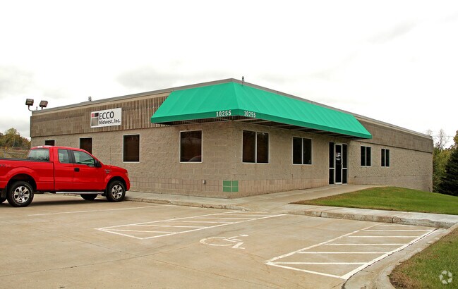
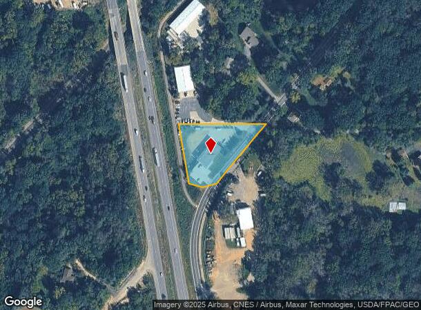
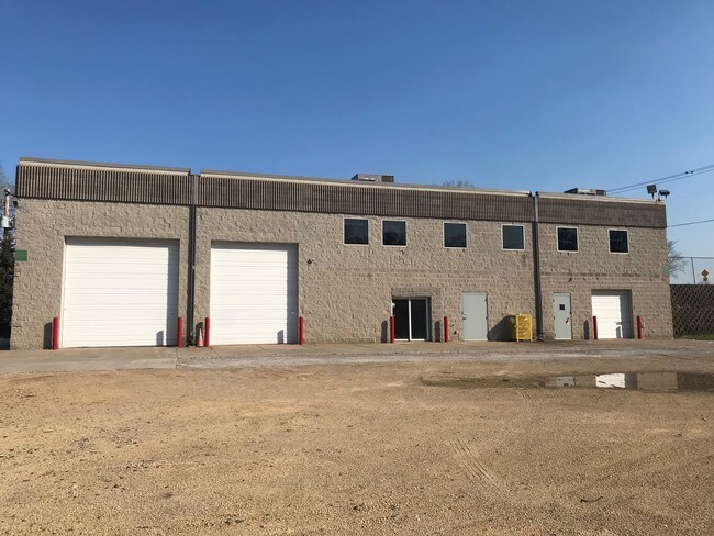
10255 Inver Grove Trl
20-02700-27-022
SECTION 27 TWN 27 RANGE 22 27 27 22 PT OF SE 1/4 OF NW 1/4 LY NWLY SAR #77 & NELY STH 52-55-56
Commercialnec
Dakota
X
Minnesota
27037C0120E
22
2024
1.29 AC
2024
South Central
060509
Minneapolis/St Paul
8,400 SF
Minneapolis-St. Paul-Bloomington, MN-WI
DEMOGRAPHICS near 10255 Inver Grove Trl
1 Mile
3 Mile
5 Mile
2024 Total Population
583
15,107
73,793
2029 Population
592
15,379
76,829
Pop Growth 2024-2029
+ 1.54%
+ 1.80%
+ 4.11%
Average Age
43
42
40
2024 Total Households
205
5,958
26,963
HH Growth 2024-2029
+ 1.46%
+ 1.71%
+ 4.03%
Median Household Inc
$141,666
$100,322
$106,716
Avg Household Size
2.80
2.50
2.70
2024 Avg HH Vehicles
3.00
2.00
2.00
Median Home Value
$466,264
$356,034
$343,980
Median Year Built
1988
1991
1990
Nearby Places
Map Layers
Map Styles
 Street
 Aerial
- Restaurants
- Banks
- Shops
- Fitness
- Groceries
PUBLIC TRANSPORTATION
AIRPORT
Minneapolis-St Paul International/Wold-Chamberlain
DRIVE
WALK
Distance
Minneapolis-St Paul International/Wold-Chamberlain
22 min
14.0 mi
SALE & LEASE HISTORY
LISTING DATE
SALE/LEASE

Sep 24, 2016
For Sale
Jul 19, 2018
For Lease
Aug 13, 2019
For Lease
Nearby Properties
Address
Land Use
TOTAL SIZE
Lot Size
Zoning
Address
Land Use
TOTAL SIZE
Lot Size
Zoning
595.66 AC
Address
Land Use
TOTAL SIZE
Lot Size
Zoning
Address
Land Use
TOTAL SIZE
Lot Size
Zoning
Address
Land Use
TOTAL SIZE
Lot Size
Zoning
6,566 SF
48.32 AC
Address
Land Use
TOTAL SIZE
Lot Size
Zoning
605,774 SF
44.50 AC
Address
Land Use
TOTAL SIZE
Lot Size
Zoning
228,810 SF
6.30 AC
Address
Land Use
TOTAL SIZE
Lot Size
Zoning
212,331 SF
9.27 AC
Address
Land Use
TOTAL SIZE
Lot Size
Zoning
600 SF
348.83 AC
Address
Land Use
TOTAL SIZE
Lot Size
Zoning
114,778 SF
27.86 AC
Address
Land Use
TOTAL SIZE
Lot Size
Zoning
97,792 SF
16.39 AC
Address
Land Use
TOTAL SIZE
Lot Size
Zoning
108,000 SF
6.44 AC
Address
Land Use
TOTAL SIZE
Lot Size
Zoning
72,350 SF
1.86 AC
Address
Land Use
TOTAL SIZE
Lot Size
Zoning
96,000 SF
6.41 AC
Address
Land Use
TOTAL SIZE
Lot Size
Zoning
76,452 SF
13.76 AC
Address
Land Use
TOTAL SIZE
Lot Size
Zoning
85,104 SF
11.75 AC
Address
Land Use
TOTAL SIZE
Lot Size
Zoning
141,090 SF
16.79 AC
Address
Land Use
TOTAL SIZE
Lot Size
Zoning
71,296 SF
4.99 AC
Address
Land Use
TOTAL SIZE
Lot Size
Zoning
86,363 SF
22.51 AC
Address
Land Use
TOTAL SIZE
Lot Size
Zoning
479,206 SF
24.35 AC
Address
Land Use
TOTAL SIZE
Lot Size
Zoning
434.99 AC
Address
Land Use
TOTAL SIZE
Lot Size
Zoning
47,122 SF
2.44 AC
Address
Land Use
TOTAL SIZE
Lot Size
Zoning
Address
Land Use
TOTAL SIZE
Lot Size
Zoning
46,128 SF
25.93 AC
Address
Land Use
TOTAL SIZE
Lot Size
Zoning
129,600 SF
8.49 AC
Address
Land Use
TOTAL SIZE
Lot Size
Zoning
25,618 SF
1.84 AC
Address
Land Use
TOTAL SIZE
Lot Size
Zoning
4,400 SF
33.14 AC
Address
Land Use
TOTAL SIZE
Lot Size
Zoning
470.06 AC
Address
Land Use
TOTAL SIZE
Lot Size
Zoning
47,976 SF
7.31 AC
Address
Land Use
TOTAL SIZE
Lot Size
Zoning
56,684 SF
5.77 AC
Address
Land Use
TOTAL SIZE
Lot Size
Zoning
1,056 SF
189.82 AC
The World's #1 Commercial Real Estate Marketplace
Connect with us
© 2025 CoStar Group
The information above has been obtained from sources believed reliable. While we do not doubt its accuracy we have not verified it and make no guarantee, warranty or representation about it. It is your responsibility to independently confirm its accuracy and completeness. Any projections, opinions, assumptions, or estimates used are for example only and do not represent the current or future performance of the property. The value of this transaction to you depends on tax and other factors which should be evaluated by your tax, financial, and legal advisors. You and your advisors should conduct a careful, independent investigation of the property to determine to your satisfaction the suitability of the property for your needs.