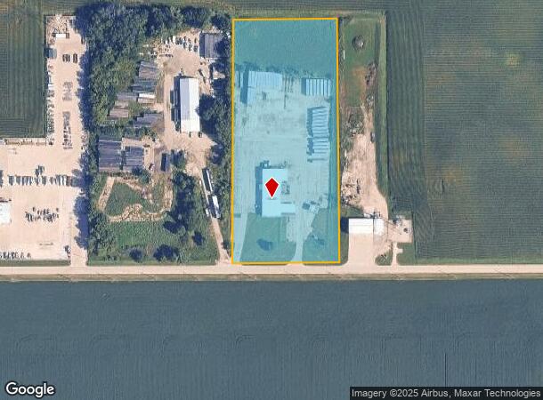
Property Record
10255 Keslinger Rd, Dekalb, IL 60115

NEARBY LISTINGS FOR SALE OR LEASE
-
-
-
-
-
-
-
No Photo
-
View all Dekalb listings for sale on LoopNet.com
Property Detail
10255 Keslinger Rd
11-02-300-016
PT SW 1/4 - SEC 2 -T39N R4E
Commercialnec
DeKalb
X
Illinois
17037C0275E
6.65 AC
2023
I-88 West
2024
Chicago
001500
Chicago-Naperville-Elgin, IL-IN-WI
DEMOGRAPHICS near 10255 Keslinger Rd
1 Mile
3 Mile
5 Mile
2024 Total Population
46
5,691
42,681
2029 Population
45
5,611
42,755
Pop Growth 2024-2029
(2.17%)
(1.41%)
+ 0.17%
Average Age
39
41
33
2024 Total Households
19
2,226
16,396
HH Growth 2024-2029
(5.26%)
(1.53%)
+ 0.29%
Median Household Inc
$74,999
$67,578
$48,413
Avg Household Size
2.60
2.40
2.30
2024 Avg HH Vehicles
2.00
2.00
2.00
Median Home Value
$168,749
$157,184
$169,790
Median Year Built
1957
1984
1976
Nearby Places
Map Layers
Map Styles
 Street
 Aerial
- Restaurants
- Banks
- Shops
- Fitness
- Groceries
PUBLIC TRANSPORTATION
AIRPORT
Chicago/Rockford International
DRIVE
WALK
Distance
Chicago/Rockford International
56 min
40.4 mi
Freight Ports
Port Milwaukee
DRIVE
WALK
Distance
Port Milwaukee
148 min
106.5 mi
SALE & LEASE HISTORY
LISTING DATE
SALE/LEASE

Oct 07, 2020
For Sale
Nearby Properties
Address
Land Use
TOTAL SIZE
Lot Size
Zoning
Address
Land Use
TOTAL SIZE
Lot Size
Zoning
227.72 AC
Address
Land Use
TOTAL SIZE
Lot Size
Zoning
71.90 AC
Address
Land Use
TOTAL SIZE
Lot Size
Zoning
49.71 AC
Address
Land Use
TOTAL SIZE
Lot Size
Zoning
58.65 AC
Address
Land Use
TOTAL SIZE
Lot Size
Zoning
33.65 AC
Address
Land Use
TOTAL SIZE
Lot Size
Zoning
49.73 AC
Address
Land Use
TOTAL SIZE
Lot Size
Zoning
98.56 AC
Address
Land Use
TOTAL SIZE
Lot Size
Zoning
43.10 AC
Address
Land Use
TOTAL SIZE
Lot Size
Zoning
94.65 AC
Address
Land Use
TOTAL SIZE
Lot Size
Zoning
47.87 AC
Address
Land Use
TOTAL SIZE
Lot Size
Zoning
257.54 AC
Address
Land Use
TOTAL SIZE
Lot Size
Zoning
21.61 AC
Address
Land Use
TOTAL SIZE
Lot Size
Zoning
25.70 AC
Address
Land Use
TOTAL SIZE
Lot Size
Zoning
21.35 AC
Address
Land Use
TOTAL SIZE
Lot Size
Zoning
9.88 AC
Address
Land Use
TOTAL SIZE
Lot Size
Zoning
57.46 AC
Address
Land Use
TOTAL SIZE
Lot Size
Zoning
8.78 AC
Address
Land Use
TOTAL SIZE
Lot Size
Zoning
2.91 AC
Address
Land Use
TOTAL SIZE
Lot Size
Zoning
7.80 AC
PDC
Address
Land Use
TOTAL SIZE
Lot Size
Zoning
2.24 AC
Address
Land Use
TOTAL SIZE
Lot Size
Zoning
3.14 AC
Address
Land Use
TOTAL SIZE
Lot Size
Zoning
12.93 AC
Address
Land Use
TOTAL SIZE
Lot Size
Zoning
4.29 AC
Address
Land Use
TOTAL SIZE
Lot Size
Zoning
1.92 AC
Address
Land Use
TOTAL SIZE
Lot Size
Zoning
1.92 AC
Address
Land Use
TOTAL SIZE
Lot Size
Zoning
1.54 AC
Address
Land Use
TOTAL SIZE
Lot Size
Zoning
1.92 AC
Address
Land Use
TOTAL SIZE
Lot Size
Zoning
3.61 AC
A1
Address
Land Use
TOTAL SIZE
Lot Size
Zoning
1.65 AC
Address
Land Use
TOTAL SIZE
Lot Size
Zoning
2.02 AC
The World's #1 Commercial Real Estate Marketplace
Connect with us
© 2025 CoStar Group
The information above has been obtained from sources believed reliable. While we do not doubt its accuracy we have not verified it and make no guarantee, warranty or representation about it. It is your responsibility to independently confirm its accuracy and completeness. Any projections, opinions, assumptions, or estimates used are for example only and do not represent the current or future performance of the property. The value of this transaction to you depends on tax and other factors which should be evaluated by your tax, financial, and legal advisors. You and your advisors should conduct a careful, independent investigation of the property to determine to your satisfaction the suitability of the property for your needs.