Property Record
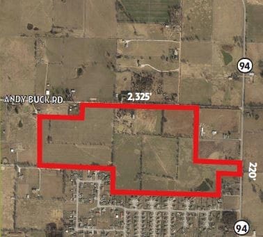
10257 N Andy Buck Rd, Pea Ridge, AR 72751
NEARBY LISTINGS FOR SALE OR LEASE
Property Detail
10257 N Andy Buck Rd
18-07925-002
Rural
Residentialacreage
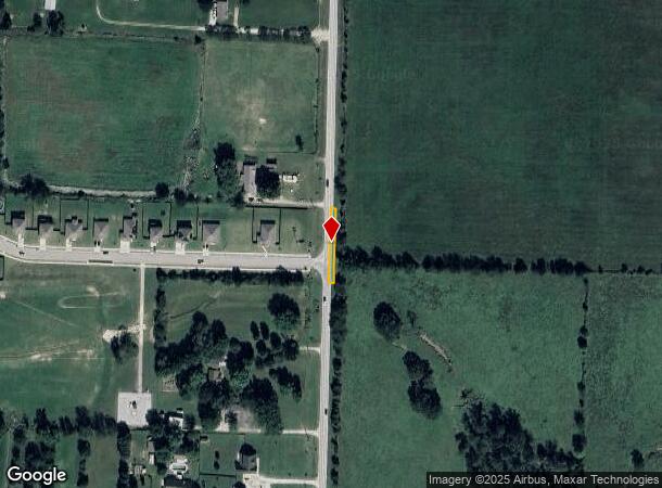
ALL PROPERTY FALLING IN THE ARKANSAS HIGHWAY NO. 94 ROW AND A 20 STRIP OF PROPERTY RUNNING FROM NORTH TO SOUTH ALONG THE WEST RIGHT OF WAY HIGHWAY NO. 94
X
Benton
29119C0450D
Arkansas
0
0.11 AC
2025
Outlying Benton County
020103
Fayetteville/Springdale/Rogers
1,648 SF
Fayetteville-Springdale-Rogers, AR-MO
DEMOGRAPHICS near 10257 N Andy Buck Rd
1 Mile
3 Mile
5 Mile
2024 Total Population
774
12,354
25,508
2029 Population
921
14,671
30,031
Pop Growth 2024-2029
+ 18.99%
+ 18.76%
+ 17.73%
Average Age
36
39
40
2024 Total Households
256
4,408
9,483
HH Growth 2024-2029
+ 19.53%
+ 18.74%
+ 17.67%
Median Household Inc
$85,080
$81,722
$81,032
Avg Household Size
3.00
2.80
2.60
2024 Avg HH Vehicles
2.00
2.00
2.00
Median Home Value
$218,750
$225,891
$235,802
Median Year Built
2001
1997
1997
Nearby Places
Map Layers
Map Styles
 Street
 Aerial
- Restaurants
- Banks
- Shops
- Fitness
- Groceries
PUBLIC TRANSPORTATION
AIRPORT
Northwest Arkansas Ntl
DRIVE
WALK
Distance
Northwest Arkansas Ntl
42 min
22.1 mi
Freight Ports
Tulsa Port of Inola
DRIVE
WALK
Distance
Tulsa Port of Inola
128 min
107.3 mi
SALE & LEASE HISTORY
LISTING DATE
SALE/LEASE

Jan 11, 2019
For Sale
Nearby Properties
Address
Land Use
TOTAL SIZE
Lot Size
Zoning
Address
Land Use
TOTAL SIZE
Lot Size
Zoning
28,501 SF
5.95 AC
Address
Land Use
TOTAL SIZE
Lot Size
Zoning
7,650 SF
5.63 AC
Address
Land Use
TOTAL SIZE
Lot Size
Zoning
41,940 SF
36.20 AC
Address
Land Use
TOTAL SIZE
Lot Size
Zoning
146,778 SF
10.32 AC
Address
Land Use
TOTAL SIZE
Lot Size
Zoning
5,936 SF
1.03 AC
Address
Land Use
TOTAL SIZE
Lot Size
Zoning
6,870 SF
1.66 AC
Address
Land Use
TOTAL SIZE
Lot Size
Zoning
60,356 SF
3.48 AC
Address
Land Use
TOTAL SIZE
Lot Size
Zoning
6,088 SF
1.51 AC
Address
Land Use
TOTAL SIZE
Lot Size
Zoning
22,141 SF
2.21 AC
Address
Land Use
TOTAL SIZE
Lot Size
Zoning
7,114 SF
1.50 AC
Address
Land Use
TOTAL SIZE
Lot Size
Zoning
20,883 SF
6.35 AC
Address
Land Use
TOTAL SIZE
Lot Size
Zoning
8,598 SF
0.91 AC
Address
Land Use
TOTAL SIZE
Lot Size
Zoning
3,960 SF
1.13 AC
Address
Land Use
TOTAL SIZE
Lot Size
Zoning
13,056 SF
2.41 AC
Address
Land Use
TOTAL SIZE
Lot Size
Zoning
11,738 SF
2.04 AC
Address
Land Use
TOTAL SIZE
Lot Size
Zoning
6,811 SF
0.95 AC
Address
Land Use
TOTAL SIZE
Lot Size
Zoning
3,667 SF
1.15 AC
Address
Land Use
TOTAL SIZE
Lot Size
Zoning
2,904 SF
0.86 AC
Address
Land Use
TOTAL SIZE
Lot Size
Zoning
6,400 SF
2.86 AC
Address
Land Use
TOTAL SIZE
Lot Size
Zoning
10,920 SF
0.89 AC
Address
Land Use
TOTAL SIZE
Lot Size
Zoning
14,820 SF
1.33 AC
Address
Land Use
TOTAL SIZE
Lot Size
Zoning
9,666 SF
1.53 AC
Address
Land Use
TOTAL SIZE
Lot Size
Zoning
11,200 SF
1.16 AC
Address
Land Use
TOTAL SIZE
Lot Size
Zoning
7,680 SF
0.95 AC
Address
Land Use
TOTAL SIZE
Lot Size
Zoning
4,300 SF
Address
Land Use
TOTAL SIZE
Lot Size
Zoning
12,208 SF
1.45 AC
Address
Land Use
TOTAL SIZE
Lot Size
Zoning
2,656 SF
0.27 AC
Address
Land Use
TOTAL SIZE
Lot Size
Zoning
2,290 SF
0.95 AC
Address
Land Use
TOTAL SIZE
Lot Size
Zoning
2,167 SF
0.95 AC
Address
Land Use
TOTAL SIZE
Lot Size
Zoning
3,120 SF
1.40 AC
The World's #1 Commercial Real Estate Marketplace
Connect with us
© 2025 CoStar Group
The information above has been obtained from sources believed reliable. While we do not doubt its accuracy we have not verified it and make no guarantee, warranty or representation about it. It is your responsibility to independently confirm its accuracy and completeness. Any projections, opinions, assumptions, or estimates used are for example only and do not represent the current or future performance of the property. The value of this transaction to you depends on tax and other factors which should be evaluated by your tax, financial, and legal advisors. You and your advisors should conduct a careful, independent investigation of the property to determine to your satisfaction the suitability of the property for your needs.