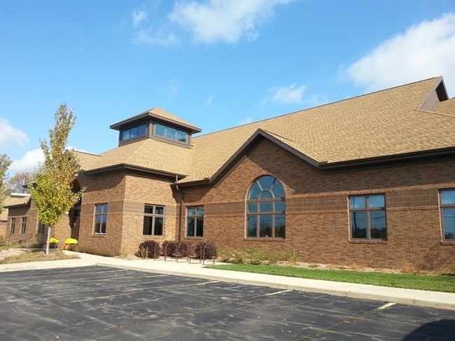
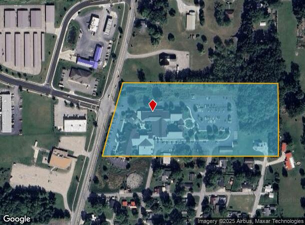
Property Record
1026 N Main St, Goshen, IN 46528
NEARBY LISTINGS FOR SALE OR LEASE
Property Detail
1026 N Main St
20-11-04-426-006.000-015
IN NE SE SEC 4 10.00A
Religious
Elkhart
X
Indiana
18039C0252D
10 AC
2024
Outlying Elkhart County
2025
South Bend/Mishawaka
000602
Elkhart-Goshen, IN
86,777 SF
DEMOGRAPHICS near 1026 N Main St
1 Mile
3 Mile
5 Mile
2024 Total Population
5,826
35,897
54,633
2029 Population
5,868
35,891
54,537
Pop Growth 2024-2029
+ 0.72%
(0.02%)
(0.18%)
Average Age
34
38
38
2024 Total Households
1,866
12,946
19,095
HH Growth 2024-2029
+ 0.64%
(0.11%)
(0.25%)
Median Household Inc
$44,391
$56,229
$63,614
Avg Household Size
3.00
2.60
2.70
2024 Avg HH Vehicles
2.00
2.00
2.00
Median Home Value
$119,413
$161,533
$179,543
Median Year Built
1957
1976
1982
Nearby Places
Map Layers
Map Styles
 Street
 Aerial
- Restaurants
- Banks
- Shops
- Fitness
- Groceries
PUBLIC TRANSPORTATION
AIRPORT
South Bend International
DRIVE
WALK
Distance
South Bend International
55 min
34.0 mi
Freight Ports
Port of Toledo
DRIVE
WALK
Distance
Port of Toledo
172 min
141.5 mi
SALE & LEASE HISTORY
LISTING DATE
SALE/LEASE

Sep 25, 2016
For Lease
Aug 07, 2018
For Lease
Nearby Properties
Address
Land Use
TOTAL SIZE
Lot Size
Zoning
Address
Land Use
TOTAL SIZE
Lot Size
Zoning
319,390 SF
11.15 AC
ZO01
Address
Land Use
TOTAL SIZE
Lot Size
Zoning
153,057 SF
21.48 AC
ZO01
Address
Land Use
TOTAL SIZE
Lot Size
Zoning
218,892 SF
34.41 AC
ZO01
Address
Land Use
TOTAL SIZE
Lot Size
Zoning
78,935 SF
13.05 AC
ZO01
Address
Land Use
TOTAL SIZE
Lot Size
Zoning
222,268 SF
11.22 AC
ZO01
Address
Land Use
TOTAL SIZE
Lot Size
Zoning
70,060 SF
7.06 AC
ZO01
Address
Land Use
TOTAL SIZE
Lot Size
Zoning
115,347 SF
19.94 AC
ZO01
Address
Land Use
TOTAL SIZE
Lot Size
Zoning
46,442 SF
0.97 AC
ZO01
Address
Land Use
TOTAL SIZE
Lot Size
Zoning
259,034 SF
16.33 AC
ZO01
Address
Land Use
TOTAL SIZE
Lot Size
Zoning
101,821 SF
113.39 AC
ZO01
Address
Land Use
TOTAL SIZE
Lot Size
Zoning
85,680 SF
55.02 AC
ZO01
Address
Land Use
TOTAL SIZE
Lot Size
Zoning
49,329 SF
6.23 AC
ZO01
Address
Land Use
TOTAL SIZE
Lot Size
Zoning
79,864 SF
3.82 AC
ZO01
Address
Land Use
TOTAL SIZE
Lot Size
Zoning
98,559 SF
33 AC
ZO01
Address
Land Use
TOTAL SIZE
Lot Size
Zoning
126,937 SF
3.21 AC
ZO01
Address
Land Use
TOTAL SIZE
Lot Size
Zoning
23,457 SF
9.01 AC
ZO01
Address
Land Use
TOTAL SIZE
Lot Size
Zoning
31,746 SF
44.60 AC
ZO01
Address
Land Use
TOTAL SIZE
Lot Size
Zoning
53,856 SF
3.07 AC
ZO01
Address
Land Use
TOTAL SIZE
Lot Size
Zoning
26,432 SF
5.99 AC
ZO01
Address
Land Use
TOTAL SIZE
Lot Size
Zoning
74,766 SF
9.46 AC
ZO01
Address
Land Use
TOTAL SIZE
Lot Size
Zoning
54,548 SF
13.16 AC
ZO01
Address
Land Use
TOTAL SIZE
Lot Size
Zoning
114,023 SF
10.31 AC
ZO01
Address
Land Use
TOTAL SIZE
Lot Size
Zoning
26,336 SF
1.06 AC
ZO01
Address
Land Use
TOTAL SIZE
Lot Size
Zoning
114,859 SF
10.73 AC
ZO01
Address
Land Use
TOTAL SIZE
Lot Size
Zoning
29,066 SF
13.55 AC
ZO01
Address
Land Use
TOTAL SIZE
Lot Size
Zoning
66,120 SF
11.80 AC
ZO01
Address
Land Use
TOTAL SIZE
Lot Size
Zoning
46,761 SF
3.10 AC
ZO01
Address
Land Use
TOTAL SIZE
Lot Size
Zoning
58,526 SF
7.38 AC
ZO01
Address
Land Use
TOTAL SIZE
Lot Size
Zoning
53,685 SF
13.38 AC
ZO01
The World's #1 Commercial Real Estate Marketplace
Connect with us
© 2026 CoStar Group
The information above has been obtained from sources believed reliable. While we do not doubt its accuracy we have not verified it and make no guarantee, warranty or representation about it. It is your responsibility to independently confirm its accuracy and completeness. Any projections, opinions, assumptions, or estimates used are for example only and do not represent the current or future performance of the property. The value of this transaction to you depends on tax and other factors which should be evaluated by your tax, financial, and legal advisors. You and your advisors should conduct a careful, independent investigation of the property to determine to your satisfaction the suitability of the property for your needs.