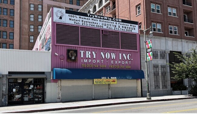
Property Record
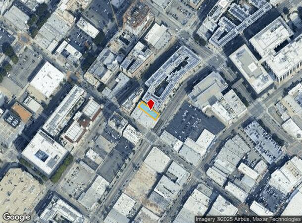
1053 S Main St, Los Angeles, CA 90015
NEARBY LISTINGS FOR SALE OR LEASE
Property Detail
1053 S Main St
Los Angeles-Long Beach-Glendale, CA
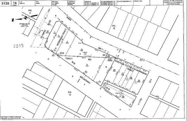
E H Workman Tract
5139-014-005
ADD TO E H WORKMAN TRACT NE 20 FT MEASURED ON NW AND SE LINES EX OF ST OF LOT 26 AND SW 20 FT MEASURED ON NW AND SE LINES EX OF ST OF LOT 27
Lightindustrial
Los Angeles
X
California
06037C1617G
26
2024
0.13 AC
2025
Downtown Los Angeles
207902
Los Angeles
12,880 SF
DEMOGRAPHICS near 1053 S Main St
1 Mile
3 Mile
5 Mile
2024 Total Population
61,706
512,013
1,182,001
2029 Population
61,547
496,471
1,142,733
Pop Growth 2024-2029
(0.26%)
(3.04%)
(3.32%)
Average Age
40
37
38
2024 Total Households
33,566
185,639
405,729
HH Growth 2024-2029
(0.03%)
(2.71%)
(3.20%)
Median Household Inc
$57,044
$46,465
$52,546
Avg Household Size
1.60
2.50
2.70
2024 Avg HH Vehicles
1.00
1.00
1.00
Median Home Value
$850,157
$734,511
$770,867
Median Year Built
2000
1966
1955
Nearby Places
- Restaurants
- Banks
- Shops
- Fitness
- Groceries
PUBLIC TRANSPORTATION
TRANSIT/SUBWAY
Pico Station (Blue Line - Los Angeles County Metropolitan Transportation Authority (Metro), Expo Line - Los Angeles County Metropolitan Transportation Authority (Metro))
DRIVE
WALK
Distance
Pico Station (Blue Line - Los Angeles County Metropolitan Transportation Authority (Metro), Expo Line - Los Angeles County Metropolitan Transportation Authority (Metro))
1 min
11 min
0.6 mi
7Th Street/Metro Center Station (Blue Line - Los Angeles County Metropolitan Transportation Authority (Metro), Expo Line - Los Angeles County Metropolitan Transportation Authority (Metro), Purple Line - Los Angeles County Metropolitan Transportation Authority (Metro), Red Line - Los Angeles County Metropolitan Transportation Authority (Metro))
DRIVE
WALK
Distance
7Th Street/Metro Center Station (Blue Line - Los Angeles County Metropolitan Transportation Authority (Metro), Expo Line - Los Angeles County Metropolitan Transportation Authority (Metro), Purple Line - Los Angeles County Metropolitan Transportation Authority (Metro), Red Line - Los Angeles County Metropolitan Transportation Authority (Metro))
2 min
16 min
0.9 mi
Pershing Square Station (Purple Line - Los Angeles County Metropolitan Transportation Authority (Metro), Red Line - Los Angeles County Metropolitan Transportation Authority (Metro))
DRIVE
WALK
Distance
Pershing Square Station (Purple Line - Los Angeles County Metropolitan Transportation Authority (Metro), Red Line - Los Angeles County Metropolitan Transportation Authority (Metro))
2 min
17 min
0.9 mi
Grand Station (Blue Line - Los Angeles County Metropolitan Transportation Authority (Metro))
DRIVE
WALK
Distance
Grand Station (Blue Line - Los Angeles County Metropolitan Transportation Authority (Metro))
2 min
18 min
0.9 mi
COMMUTER RAIL
Los Angeles (Coast Starlight - Amtrak, Pacific Surfliner - Amtrak, Southwest Chief - Amtrak, Texas Eagle - Amtrak)
DRIVE
WALK
Distance
Los Angeles (Coast Starlight - Amtrak, Pacific Surfliner - Amtrak, Southwest Chief - Amtrak, Texas Eagle - Amtrak)
4 min
1.9 mi
Union Station (91 Line - Southern California Regional Rail Authority (Metrolink), Antelope Valley Line - Southern California Regional Rail Authority (Metrolink), Orange County Line - Southern California Regional Rail Authority (Metrolink), Riverside Line - Southern California Regional Rail Authority (Metrolink), San Bernardino Line - Southern California Regional Rail Authority (Metrolink), Ventura County Line - Southern California Regional Rail Authority (Metrolink))
DRIVE
WALK
Distance
Union Station (91 Line - Southern California Regional Rail Authority (Metrolink), Antelope Valley Line - Southern California Regional Rail Authority (Metrolink), Orange County Line - Southern California Regional Rail Authority (Metrolink), Riverside Line - Southern California Regional Rail Authority (Metrolink), San Bernardino Line - Southern California Regional Rail Authority (Metrolink), Ventura County Line - Southern California Regional Rail Authority (Metrolink))
6 min
2.1 mi
AIRPORT
Los Angeles International
DRIVE
WALK
Distance
Los Angeles International
24 min
14.4 mi
Bob Hope
DRIVE
WALK
Distance
Bob Hope
26 min
18.2 mi
Long Beach (Daugherty Field)
DRIVE
WALK
Distance
Long Beach (Daugherty Field)
30 min
21.9 mi
Freight Ports
Port of Long Beach
DRIVE
WALK
Distance
Port of Long Beach
33 min
23.8 mi
SALE & LEASE HISTORY
LISTING DATE
SALE/LEASE

Jul 11, 2022
For Lease
Jul 11, 2022
For Sale
Nearby Properties
Address
Land Use
TOTAL SIZE
Lot Size
Zoning
Address
Land Use
TOTAL SIZE
Lot Size
Zoning
2,832,748 SF
4.20 AC
LAC2
Address
Land Use
TOTAL SIZE
Lot Size
Zoning
1,392,719 SF
4.22 AC
LAC4
Address
Land Use
TOTAL SIZE
Lot Size
Zoning
2,001,034 SF
2.71 AC
LAC2
Address
Land Use
TOTAL SIZE
Lot Size
Zoning
969,516 SF
14.75 AC
Address
Land Use
TOTAL SIZE
Lot Size
Zoning
1,462,729 SF
1.39 AC
LAC2
Address
Land Use
TOTAL SIZE
Lot Size
Zoning
108,464 SF
9.17 AC
LALASED
Address
Land Use
TOTAL SIZE
Lot Size
Zoning
969,264 SF
0.94 AC
LAC2
Address
Land Use
TOTAL SIZE
Lot Size
Zoning
717,065 SF
0.99 AC
LAC2
Address
Land Use
TOTAL SIZE
Lot Size
Zoning
1,039,642 SF
2.84 AC
LAC2
Address
Land Use
TOTAL SIZE
Lot Size
Zoning
1,486,375 SF
3.77 AC
LAR5
Address
Land Use
TOTAL SIZE
Lot Size
Zoning
1,457,208 SF
1.39 AC
LAC2
Address
Land Use
TOTAL SIZE
Lot Size
Zoning
949,529 SF
1.50 AC
LAC2
Address
Land Use
TOTAL SIZE
Lot Size
Zoning
200,811 SF
4.59 AC
LALASED
Address
Land Use
TOTAL SIZE
Lot Size
Zoning
1,178,786 SF
3.89 AC
LAC2
Address
Land Use
TOTAL SIZE
Lot Size
Zoning
764,804 SF
1.48 AC
Address
Land Use
TOTAL SIZE
Lot Size
Zoning
634,863 SF
2.97 AC
LAC2-4D
Address
Land Use
TOTAL SIZE
Lot Size
Zoning
1,346,113 SF
1.17 AC
LAC5
Address
Land Use
TOTAL SIZE
Lot Size
Zoning
738,975 SF
2.71 AC
LAC2
Address
Land Use
TOTAL SIZE
Lot Size
Zoning
1,094,768 SF
0.73 AC
LAC2
Address
Land Use
TOTAL SIZE
Lot Size
Zoning
420,864 SF
63.07 AC
LAUSC-1A
Address
Land Use
TOTAL SIZE
Lot Size
Zoning
574,047 SF
1.70 AC
LAR5
Address
Land Use
TOTAL SIZE
Lot Size
Zoning
705,234 SF
1.83 AC
LAC2
Address
Land Use
TOTAL SIZE
Lot Size
Zoning
966,466 SF
3.99 AC
LAC2
Address
Land Use
TOTAL SIZE
Lot Size
Zoning
816,046 SF
15.37 AC
LAA1
Address
Land Use
TOTAL SIZE
Lot Size
Zoning
773,409 SF
1.39 AC
LAC4
Address
Land Use
TOTAL SIZE
Lot Size
Zoning
1,005,477 SF
1.36 AC
LAC4
Address
Land Use
TOTAL SIZE
Lot Size
Zoning
2,697,158 SF
20.18 AC
LAM2
Address
Land Use
TOTAL SIZE
Lot Size
Zoning
256,059 SF
Address
Land Use
TOTAL SIZE
Lot Size
Zoning
641,453 SF
2.93 AC
LAC4
Address
Land Use
TOTAL SIZE
Lot Size
Zoning
581,956 SF
0.89 AC
LAR5
The World's #1 Commercial Real Estate Marketplace
Connect with us
© 2025 CoStar Group
The information above has been obtained from sources believed reliable. While we do not doubt its accuracy we have not verified it and make no guarantee, warranty or representation about it. It is your responsibility to independently confirm its accuracy and completeness. Any projections, opinions, assumptions, or estimates used are for example only and do not represent the current or future performance of the property. The value of this transaction to you depends on tax and other factors which should be evaluated by your tax, financial, and legal advisors. You and your advisors should conduct a careful, independent investigation of the property to determine to your satisfaction the suitability of the property for your needs.