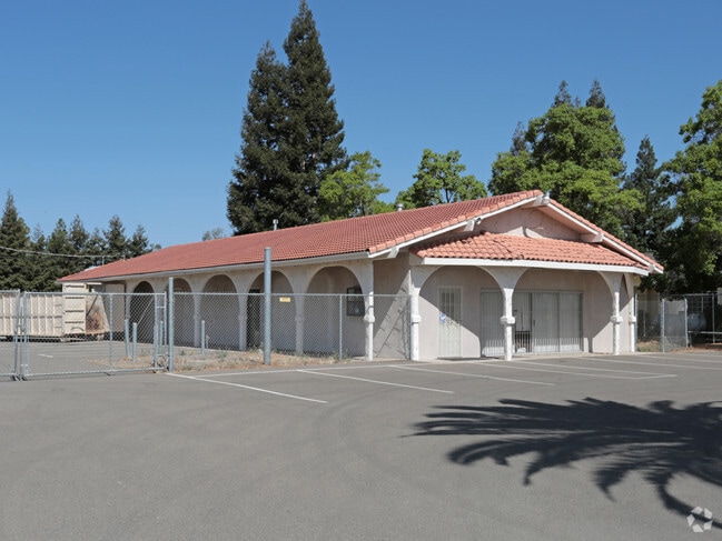
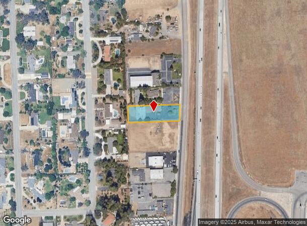
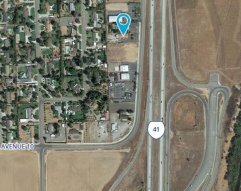
Property Record
10266 Business Route 41, Madera, CA 93636

Current Lease Availabilities
NEARBY LISTINGS FOR SALE OR LEASE
Property Detail
10266 Business Route 41
Madera, CA
Rolling Hills
049-170-005
ROLLING HILLS LOT 59
Commercialbuilding
Madera
X
California
06019C1020H
59
2024
0.77 AC
2025
Outlying Madera County
000509
Fresno
2,992 SF
DEMOGRAPHICS near 10266 Business Route 41
1 Mile
3 Mile
5 Mile
2024 Total Population
831
31,131
105,371
2029 Population
936
32,424
108,463
Pop Growth 2024-2029
+ 12.64%
+ 4.15%
+ 2.93%
Average Age
42
40
40
2024 Total Households
292
11,835
40,283
HH Growth 2024-2029
+ 12.33%
+ 3.95%
+ 2.85%
Median Household Inc
$149,431
$122,834
$97,505
Avg Household Size
2.90
2.60
2.60
2024 Avg HH Vehicles
2.00
2.00
2.00
Median Home Value
$526,978
$545,465
$446,194
Median Year Built
2010
1995
1991
Nearby Places
- Restaurants
- Banks
- Shops
- Fitness
- Groceries
PUBLIC TRANSPORTATION
AIRPORT
Fresno Yosemite International
DRIVE
WALK
Distance
Fresno Yosemite International
20 min
12.9 mi
Freight Ports
Port of Stockton
DRIVE
WALK
Distance
Port of Stockton
154 min
122.8 mi
Nearby Properties
Address
Land Use
TOTAL SIZE
Lot Size
Zoning
Address
Land Use
TOTAL SIZE
Lot Size
Zoning
39.39 AC
Address
Land Use
TOTAL SIZE
Lot Size
Zoning
143,370 SF
6.92 AC
CP
Address
Land Use
TOTAL SIZE
Lot Size
Zoning
119,869 SF
11.08 AC
C1
Address
Land Use
TOTAL SIZE
Lot Size
Zoning
188,177 SF
5.58 AC
CP
Address
Land Use
TOTAL SIZE
Lot Size
Zoning
181,538 SF
0.01 AC
CP
Address
Land Use
TOTAL SIZE
Lot Size
Zoning
152,550 SF
9.23 AC
R3
Address
Land Use
TOTAL SIZE
Lot Size
Zoning
137,094 SF
4.88 AC
CM
Address
Land Use
TOTAL SIZE
Lot Size
Zoning
122,486 SF
6.24 AC
CP
Address
Land Use
TOTAL SIZE
Lot Size
Zoning
66,476 SF
5.08 AC
CM
Address
Land Use
TOTAL SIZE
Lot Size
Zoning
45,080 SF
3.73 AC
CUR
Address
Land Use
TOTAL SIZE
Lot Size
Zoning
67,940 SF
1.09 AC
SPLIT
Address
Land Use
TOTAL SIZE
Lot Size
Zoning
67,512 SF
0.01 AC
CP
Address
Land Use
TOTAL SIZE
Lot Size
Zoning
71,442 SF
4.01 AC
CP
Address
Land Use
TOTAL SIZE
Lot Size
Zoning
73,391 SF
4.72 AC
SPLIT
Address
Land Use
TOTAL SIZE
Lot Size
Zoning
44,747 SF
3.74 AC
Address
Land Use
TOTAL SIZE
Lot Size
Zoning
25,314 SF
3.09 AC
Address
Land Use
TOTAL SIZE
Lot Size
Zoning
25,985 SF
119.22 AC
AE20
Address
Land Use
TOTAL SIZE
Lot Size
Zoning
29,265 SF
3.05 AC
C2
Address
Land Use
TOTAL SIZE
Lot Size
Zoning
1,526 SF
7.51 AC
R1C
Address
Land Use
TOTAL SIZE
Lot Size
Zoning
40,772 SF
4.78 AC
CP
Address
Land Use
TOTAL SIZE
Lot Size
Zoning
31,500 SF
2.35 AC
CP
Address
Land Use
TOTAL SIZE
Lot Size
Zoning
35,070 SF
3.53 AC
C2
Address
Land Use
TOTAL SIZE
Lot Size
Zoning
37,974 SF
2.27 AC
AE5
Address
Land Use
TOTAL SIZE
Lot Size
Zoning
2,835 SF
57.03 AC
ARV-20
Address
Land Use
TOTAL SIZE
Lot Size
Zoning
22,400 SF
2.12 AC
C2
Address
Land Use
TOTAL SIZE
Lot Size
Zoning
6,540 SF
29.38 AC
TP
The World's #1 Commercial Real Estate Marketplace
Connect with us
© 2025 CoStar Group
The information above has been obtained from sources believed reliable. While we do not doubt its accuracy we have not verified it and make no guarantee, warranty or representation about it. It is your responsibility to independently confirm its accuracy and completeness. Any projections, opinions, assumptions, or estimates used are for example only and do not represent the current or future performance of the property. The value of this transaction to you depends on tax and other factors which should be evaluated by your tax, financial, and legal advisors. You and your advisors should conduct a careful, independent investigation of the property to determine to your satisfaction the suitability of the property for your needs.