Property Record
1027 W Horsetooth Rd, Fort Collins, CO 80526
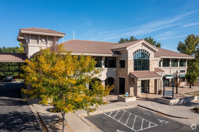

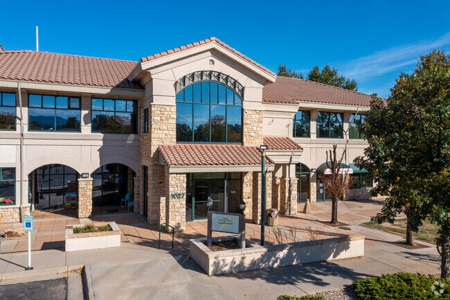

Property Detail
1027 W Horsetooth Rd
97352-65-006
LOT 6, POUDRE VALLEY PLAZA PUD, FTC
Officebuilding
LARIMER
NC
Colorado
B and X Area of moderate flood hazard, usually the area between the limits of the 100-year and 500-year floods.
6
2024
0.21 AC
2025
Fort Collins/Loveland
001109
Denver
15,848 SF
Fort Collins-Loveland, CO
NEARBY LISTINGS FOR SALE OR LEASE
DEMOGRAPHICS near 1027 W Horsetooth Rd
1 mile
3 mile
5 mile
2024 Total Population
15,738
102,289
176,819
2029 Population
16,120
105,991
182,816
Pop Growth 2024-2029
+ 2.43%
+ 3.62%
+ 3.39%
Average Age
37
36
37
2024 Total Households
6,445
41,324
71,476
HH Growth 2024-2029
+ 2.64%
+ 4.25%
+ 3.84%
Median Household Inc
$82,742
$73,864
$80,485
Avg Household Size
2.40
2.20
2.30
2024 Avg HH Vehicles
2.00
2.00
2.00
Median Home Value
$493,070
$592,739
$619,907
Median Year Built
1988
1988
1992
Nearby Places
Map Layers
Map Styles
 Street
 Aerial
Transit
 Traffic
 Biking
Places
Listings with unknown addresses are not visible on the map
- Restaurants
- Banks
- Shops
- Fitness
- Groceries
SALE & LEASE HISTORY
LISTING DATE
SALE/LEASE

Sep 25, 2016
For Lease
May 03, 2019
For Lease
Nearby Properties
Address
Land Use
TOTAL SIZE
Lot Size
Zoning
Address
Land Use
TOTAL SIZE
Lot Size
Zoning
1,096,874 SF
72 AC
CSU
Address
Land Use
TOTAL SIZE
Lot Size
Zoning
440,160 SF
29 AC
CSU
Address
Land Use
TOTAL SIZE
Lot Size
Zoning
521,085 SF
80.60 AC
CSU
Address
Land Use
TOTAL SIZE
Lot Size
Zoning
222,592 SF
21.69 AC
HC
Address
Land Use
TOTAL SIZE
Lot Size
Zoning
95,880 SF
16.69 AC
Address
Land Use
TOTAL SIZE
Lot Size
Zoning
283,141 SF
24 AC
RL
Address
Land Use
TOTAL SIZE
Lot Size
Zoning
281,945 SF
15.01 AC
NCL
Address
Land Use
TOTAL SIZE
Lot Size
Zoning
170,119 SF
12.83 AC
C
Address
Land Use
TOTAL SIZE
Lot Size
Zoning
337,566 SF
2.62 AC
Address
Land Use
TOTAL SIZE
Lot Size
Zoning
173,575 SF
28.86 AC
RL
Address
Land Use
TOTAL SIZE
Lot Size
Zoning
227,180 SF
39 AC
E
Address
Land Use
TOTAL SIZE
Lot Size
Zoning
139,965 SF
8.62 AC
CSU
Address
Land Use
TOTAL SIZE
Lot Size
Zoning
115,260 SF
9.08 AC
HC
Address
Land Use
TOTAL SIZE
Lot Size
Zoning
181,956 SF
5 AC
C
Address
Land Use
TOTAL SIZE
Lot Size
Zoning
71,244 SF
5.96 AC
C
Address
Land Use
TOTAL SIZE
Lot Size
Zoning
189,920 SF
6 AC
E
Address
Land Use
TOTAL SIZE
Lot Size
Zoning
99,997 SF
10.47 AC
NC
Address
Land Use
TOTAL SIZE
Lot Size
Zoning
263,320 SF
9.39 AC
Address
Land Use
TOTAL SIZE
Lot Size
Zoning
94,079 SF
7 AC
NC
Address
Land Use
TOTAL SIZE
Lot Size
Zoning
106,534 SF
7.55 AC
E
Address
Land Use
TOTAL SIZE
Lot Size
Zoning
363,294 SF
20.28 AC
MMN
Address
Land Use
TOTAL SIZE
Lot Size
Zoning
112,500 SF
30 AC
RL
Address
Land Use
TOTAL SIZE
Lot Size
Zoning
123,006 SF
10.27 AC
Address
Land Use
TOTAL SIZE
Lot Size
Zoning
159,256 SF
8.64 AC
C
Address
Land Use
TOTAL SIZE
Lot Size
Zoning
367,359 SF
13.36 AC
Address
Land Use
TOTAL SIZE
Lot Size
Zoning
389,012 SF
16.99 AC
MMN
Address
Land Use
TOTAL SIZE
Lot Size
Zoning
95,815 SF
7.46 AC
C
Address
Land Use
TOTAL SIZE
Lot Size
Zoning
93,138 SF
14.45 AC
MMN
The World's #1 Commercial Real Estate Marketplace
Connect with us
© 2026 CoStar Group
The information above has been obtained from sources believed reliable. While we do not doubt its accuracy we have not verified it and make no guarantee, warranty or representation about it. It is your responsibility to independently confirm its accuracy and completeness. Any projections, opinions, assumptions, or estimates used are for example only and do not represent the current or future performance of the property. The value of this transaction to you depends on tax and other factors which should be evaluated by your tax, financial, and legal advisors. You and your advisors should conduct a careful, independent investigation of the property to determine to your satisfaction the suitability of the property for your needs.