Property Record
10270 Commonwealth St, Lone Tree, CO 80124
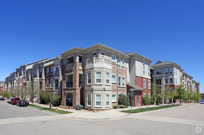


Property Detail
10270 Commonwealth St
Denver-Aurora-Centennial, CO
LOT 1 BLOCK 3 RIDGEGATE SECTION 15 FLG 11 3.24 AM/L
2231-152-16-001
Douglas
Apartment
Colorado
B and X Area of moderate flood hazard, usually the area between the limits of the 100-year and 500-year floods.
1
2024
3.24 AC
2025
Highlands Ranch-Lone Tree
014125
Denver
359,857 SF
NEARBY LISTINGS FOR SALE OR LEASE
-
-
View all Lone Tree listings for lease on LoopNet.com
DEMOGRAPHICS near 10270 Commonwealth St
1 mile
3 mile
5 mile
2025 Total Population
8,901
60,548
193,021
2030 Population
9,667
64,949
204,387
Pop Growth 2025-2030
+ 8.61%
+ 7.27%
+ 5.89%
Average Age
40
39
39
2025 Total Households
4,037
24,313
73,122
HH Growth 2025-2030
+ 8.84%
+ 7.74%
+ 6.14%
Median Household Inc
$117,499
$129,262
$138,304
Avg Household Size
2.20
2.50
2.60
2025 Avg HH Vehicles
2.00
2.00
2.00
Median Home Value
$890,243
$765,545
$743,587
Median Year Built
2010
2002
1999
Nearby Places
Map Layers
Map Styles
 Street
 Aerial
Transit
 Traffic
 Biking
Places
Listings with unknown addresses are not visible on the map
- Restaurants
- Banks
- Shops
- Fitness
- Groceries
PUBLIC TRANSPORTATION
AIRPORT
Denver International
Drive
Walk
Distance
Denver International
40 min
34.7 mi
SALE & LEASE HISTORY
LISTING DATE
SALE/LEASE

Sep 25, 2016
For Lease
Nearby Properties
Address
Land Use
TOTAL SIZE
Lot Size
Zoning
Address
Land Use
TOTAL SIZE
Lot Size
Zoning
709,725 SF
15.21 AC
Address
Land Use
TOTAL SIZE
Lot Size
Zoning
709,725 SF
29.14 AC
Address
Land Use
TOTAL SIZE
Lot Size
Zoning
805,440 SF
28.65 AC
Address
Land Use
TOTAL SIZE
Lot Size
Zoning
260,667 SF
19.72 AC
Address
Land Use
TOTAL SIZE
Lot Size
Zoning
1,630,979 SF
32.01 AC
Address
Land Use
TOTAL SIZE
Lot Size
Zoning
1,210,850 SF
13.65 AC
AMU
Address
Land Use
TOTAL SIZE
Lot Size
Zoning
364,806 SF
75.76 AC
PDU
Address
Land Use
TOTAL SIZE
Lot Size
Zoning
305,198 SF
34.41 AC
PUD
Address
Land Use
TOTAL SIZE
Lot Size
Zoning
621,565 SF
32.64 AC
PDU
Address
Land Use
TOTAL SIZE
Lot Size
Zoning
162,758 SF
11.21 AC
Address
Land Use
TOTAL SIZE
Lot Size
Zoning
650,416 SF
33.37 AC
LI
Address
Land Use
TOTAL SIZE
Lot Size
Zoning
163,443 SF
14.39 AC
Address
Land Use
TOTAL SIZE
Lot Size
Zoning
231,715 SF
5.58 AC
Address
Land Use
TOTAL SIZE
Lot Size
Zoning
661,139 SF
Address
Land Use
TOTAL SIZE
Lot Size
Zoning
488,998 SF
32.43 AC
PDU
Address
Land Use
TOTAL SIZE
Lot Size
Zoning
418,258 SF
14.46 AC
PDU
Address
Land Use
TOTAL SIZE
Lot Size
Zoning
494,862 SF
30.59 AC
PDU
Address
Land Use
TOTAL SIZE
Lot Size
Zoning
128,812 SF
2.55 AC
Address
Land Use
TOTAL SIZE
Lot Size
Zoning
651,701 SF
10.77 AC
PDU
Address
Land Use
TOTAL SIZE
Lot Size
Zoning
126,202 SF
2.27 AC
Address
Land Use
TOTAL SIZE
Lot Size
Zoning
326,230 SF
9.69 AC
Address
Land Use
TOTAL SIZE
Lot Size
Zoning
112,021 SF
3.17 AC
Address
Land Use
TOTAL SIZE
Lot Size
Zoning
632,485 SF
38.43 AC
PDU
Address
Land Use
TOTAL SIZE
Lot Size
Zoning
324,829 SF
20.45 AC
SR
Address
Land Use
TOTAL SIZE
Lot Size
Zoning
375,468 SF
23.28 AC
PDU
Address
Land Use
TOTAL SIZE
Lot Size
Zoning
201,434 SF
9.32 AC
AMU
Address
Land Use
TOTAL SIZE
Lot Size
Zoning
187,757 SF
7.47 AC
Address
Land Use
TOTAL SIZE
Lot Size
Zoning
122,017 SF
11.39 AC
PDU
Address
Land Use
TOTAL SIZE
Lot Size
Zoning
89,546 SF
9.55 AC
SR
Address
Land Use
TOTAL SIZE
Lot Size
Zoning
99,678 SF
10.25 AC
The World's #1 Commercial Real Estate Marketplace
Connect with us
© 2026 CoStar Group
The information above has been obtained from sources believed reliable. While we do not doubt its accuracy we have not verified it and make no guarantee, warranty or representation about it. It is your responsibility to independently confirm its accuracy and completeness. Any projections, opinions, assumptions, or estimates used are for example only and do not represent the current or future performance of the property. The value of this transaction to you depends on tax and other factors which should be evaluated by your tax, financial, and legal advisors. You and your advisors should conduct a careful, independent investigation of the property to determine to your satisfaction the suitability of the property for your needs.