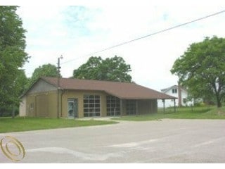
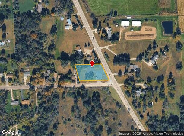
Property Record
10274 S State Rd, Goodrich, MI 48438
NEARBY LISTINGS FOR SALE OR LEASE
Property Detail
10274 S State Rd
02-35-200-029
A PARCEL OF LAND BEG S 87 DEG 30 MIN E 1034.47 FT FROM INT 1/4 COR OF SEC TH N 10 DEG 12 MIN W 191.59 FT TH S 87 DEG 30 MIN E
Commercialnec
Genesee
X
Michigan
26049C0365D
1.02 AC
2024
Flint
2025
Detroit
013401
Flint, MI
3,000 SF
DEMOGRAPHICS near 10274 S State Rd
1 Mile
3 Mile
5 Mile
2024 Total Population
662
6,913
17,012
2029 Population
639
6,741
16,753
Pop Growth 2024-2029
(3.47%)
(2.49%)
(1.52%)
Average Age
43
42
43
2024 Total Households
235
2,508
6,246
HH Growth 2024-2029
(3.40%)
(2.51%)
(1.50%)
Median Household Inc
$110,312
$99,212
$98,372
Avg Household Size
2.80
2.70
2.70
2024 Avg HH Vehicles
3.00
3.00
3.00
Median Home Value
$320,000
$295,970
$298,331
Median Year Built
1985
1983
1982
Nearby Places
Map Layers
Map Styles
 Street
 Aerial
- Restaurants
- Banks
- Shops
- Fitness
- Groceries
PUBLIC TRANSPORTATION
AIRPORT
Bishop International
DRIVE
WALK
Distance
Bishop International
42 min
26.7 mi
Freight Ports
Port of Toledo
DRIVE
WALK
Distance
Port of Toledo
129 min
97.1 mi
Nearby Properties
Address
Land Use
TOTAL SIZE
Lot Size
Zoning
Address
Land Use
TOTAL SIZE
Lot Size
Zoning
73,164 SF
12.27 AC
BI
Address
Land Use
TOTAL SIZE
Lot Size
Zoning
0.64 AC
REC
Address
Land Use
TOTAL SIZE
Lot Size
Zoning
352.82 AC
REC
Address
Land Use
TOTAL SIZE
Lot Size
Zoning
12,760 SF
16 AC
VILLAG
Address
Land Use
TOTAL SIZE
Lot Size
Zoning
27.50 AC
REC
Address
Land Use
TOTAL SIZE
Lot Size
Zoning
28,288 SF
4.98 AC
VILLAG
Address
Land Use
TOTAL SIZE
Lot Size
Zoning
319.43 AC
REC
Address
Land Use
TOTAL SIZE
Lot Size
Zoning
14.24 AC
REC
Address
Land Use
TOTAL SIZE
Lot Size
Zoning
31,813 SF
68.53 AC
FI
Address
Land Use
TOTAL SIZE
Lot Size
Zoning
11,197 SF
2.35 AC
BI
Address
Land Use
TOTAL SIZE
Lot Size
Zoning
12,958 SF
1.30 AC
VILLAG
Address
Land Use
TOTAL SIZE
Lot Size
Zoning
2,756 SF
140 AC
AR
Address
Land Use
TOTAL SIZE
Lot Size
Zoning
12,202 SF
0.83 AC
VILLAG
Address
Land Use
TOTAL SIZE
Lot Size
Zoning
75,000 SF
20.27 AC
AI
Address
Land Use
TOTAL SIZE
Lot Size
Zoning
17,363 SF
68.53 AC
FI
Address
Land Use
TOTAL SIZE
Lot Size
Zoning
12,800 SF
14.24 AC
Address
Land Use
TOTAL SIZE
Lot Size
Zoning
17,031 SF
5.02 AC
AI
Address
Land Use
TOTAL SIZE
Lot Size
Zoning
12,696 SF
110.42 AC
VILLAG
Address
Land Use
TOTAL SIZE
Lot Size
Zoning
5,292 SF
0.73 AC
VILLAG
Address
Land Use
TOTAL SIZE
Lot Size
Zoning
31,220 SF
1.61 AC
AI
Address
Land Use
TOTAL SIZE
Lot Size
Zoning
7,800 SF
2.50 AC
AI
Address
Land Use
TOTAL SIZE
Lot Size
Zoning
9,840 SF
1.21 AC
VILLAG
Address
Land Use
TOTAL SIZE
Lot Size
Zoning
2,227 SF
20.44 AC
AR
Address
Land Use
TOTAL SIZE
Lot Size
Zoning
1,792 SF
153.33 AC
RA
Address
Land Use
TOTAL SIZE
Lot Size
Zoning
12,057 SF
0.86 AC
VILLAG
Address
Land Use
TOTAL SIZE
Lot Size
Zoning
24,200 SF
2.49 AC
AI
Address
Land Use
TOTAL SIZE
Lot Size
Zoning
6,000 SF
0.85 AC
VILLAG
Address
Land Use
TOTAL SIZE
Lot Size
Zoning
3,096 SF
4.68 AC
VILLAG
Address
Land Use
TOTAL SIZE
Lot Size
Zoning
5,890 SF
4.87 AC
AI
Address
Land Use
TOTAL SIZE
Lot Size
Zoning
4,960 SF
0.40 AC
VILLAG
The World's #1 Commercial Real Estate Marketplace
Connect with us
© 2025 CoStar Group
The information above has been obtained from sources believed reliable. While we do not doubt its accuracy we have not verified it and make no guarantee, warranty or representation about it. It is your responsibility to independently confirm its accuracy and completeness. Any projections, opinions, assumptions, or estimates used are for example only and do not represent the current or future performance of the property. The value of this transaction to you depends on tax and other factors which should be evaluated by your tax, financial, and legal advisors. You and your advisors should conduct a careful, independent investigation of the property to determine to your satisfaction the suitability of the property for your needs.