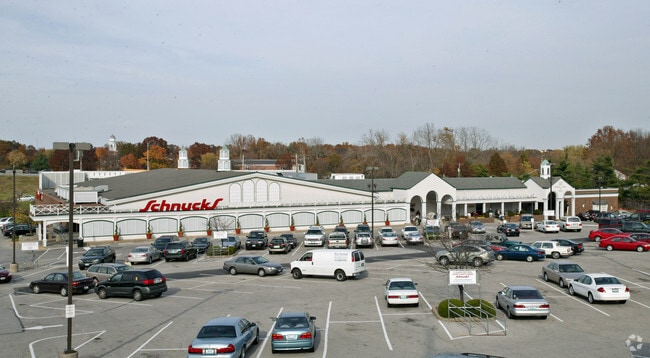
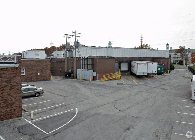
Property Record
10263 Clayton Rd, Saint Louis, MO 63124

NEARBY LISTINGS FOR SALE OR LEASE
Property Detail
10263 Clayton Rd
St. Louis, MO-IL
Berry Estate
20M-44-0419
SURVEY 2675 TWN 45 R 5 (AKA BERRY ESTATE LOT PT 3)
Supermarket
St. Louis
X
Missouri
29189C0194K
3
2024
5.44 AC
2025
Mid County
217500
St. Louis
63,555 SF
DEMOGRAPHICS near 10263 Clayton Rd
1 Mile
3 Mile
5 Mile
2024 Total Population
3,721
52,224
205,150
2029 Population
3,663
51,120
201,378
Pop Growth 2024-2029
(1.56%)
(2.11%)
(1.84%)
Average Age
43
42
42
2024 Total Households
1,346
20,719
86,424
HH Growth 2024-2029
(1.71%)
(2.12%)
(1.85%)
Median Household Inc
$209,618
$139,893
$99,437
Avg Household Size
2.80
2.50
2.30
2024 Avg HH Vehicles
2.00
2.00
2.00
Median Home Value
$907,157
$606,114
$413,896
Median Year Built
1958
1960
1960
Nearby Places
Map Layers
Map Styles
 Street
 Aerial
- Restaurants
- Banks
- Shops
- Fitness
- Groceries
PUBLIC TRANSPORTATION
COMMUTER RAIL
Richmond Heights (Shrewsbury-Lansdowne I-44 Emerson Park - St. Louis MetroLink (MetroLink))
DRIVE
WALK
Distance
Richmond Heights (Shrewsbury-Lansdowne I-44 Emerson Park - St. Louis MetroLink (MetroLink))
7 min
4.2 mi
Clayton (Shrewsbury-Lansdowne I-44 Emerson Park - St. Louis MetroLink (MetroLink))
DRIVE
WALK
Distance
Clayton (Shrewsbury-Lansdowne I-44 Emerson Park - St. Louis MetroLink (MetroLink))
7 min
5.3 mi
AIRPORT
St Louis Lambert International
DRIVE
WALK
Distance
St Louis Lambert International
20 min
13.8 mi
Freight Ports
Port Milwaukee
DRIVE
WALK
Distance
Port Milwaukee
433 min
381.7 mi
SALE & LEASE HISTORY
LISTING DATE
SALE/LEASE

Sep 25, 2016
For Lease
Nearby Properties
Address
Land Use
TOTAL SIZE
Lot Size
Zoning
Address
Land Use
TOTAL SIZE
Lot Size
Zoning
20,852 SF
48.33 AC
82PH
Address
Land Use
TOTAL SIZE
Lot Size
Zoning
389,075 SF
19.85 AC
83H
Address
Land Use
TOTAL SIZE
Lot Size
Zoning
43,617 SF
7.04 AC
83O
Address
Land Use
TOTAL SIZE
Lot Size
Zoning
34.35 AC
25R-1
Address
Land Use
TOTAL SIZE
Lot Size
Zoning
52.13 AC
42PA
Address
Land Use
TOTAL SIZE
Lot Size
Zoning
434,971 SF
24.80 AC
G
Address
Land Use
TOTAL SIZE
Lot Size
Zoning
201,879 SF
29.52 AC
82RO
Address
Land Use
TOTAL SIZE
Lot Size
Zoning
442,503 SF
3.52 AC
82PH
Address
Land Use
TOTAL SIZE
Lot Size
Zoning
33.71 AC
R3
Address
Land Use
TOTAL SIZE
Lot Size
Zoning
56.62 AC
82A
Address
Land Use
TOTAL SIZE
Lot Size
Zoning
1,280,539 SF
151.20 AC
H
Address
Land Use
TOTAL SIZE
Lot Size
Zoning
544,556 SF
95.75 AC
H
Address
Land Use
TOTAL SIZE
Lot Size
Zoning
4,150 SF
21.42 AC
83H
Address
Land Use
TOTAL SIZE
Lot Size
Zoning
31.83 AC
R2
Address
Land Use
TOTAL SIZE
Lot Size
Zoning
314,640 SF
4.70 AC
83H
Address
Land Use
TOTAL SIZE
Lot Size
Zoning
3.52 AC
82PH
Address
Land Use
TOTAL SIZE
Lot Size
Zoning
97,479 SF
21.51 AC
82HE
Address
Land Use
TOTAL SIZE
Lot Size
Zoning
17,371 SF
25.44 AC
SL1
Address
Land Use
TOTAL SIZE
Lot Size
Zoning
10.57 AC
33C
Address
Land Use
TOTAL SIZE
Lot Size
Zoning
160,628 SF
1.47 AC
82R0
Address
Land Use
TOTAL SIZE
Lot Size
Zoning
9,830 SF
7.72 AC
B
Address
Land Use
TOTAL SIZE
Lot Size
Zoning
10.30 AC
A
Address
Land Use
TOTAL SIZE
Lot Size
Zoning
204,349 SF
19.07 AC
83POP
Address
Land Use
TOTAL SIZE
Lot Size
Zoning
221,611 SF
7.08 AC
25C-1
Address
Land Use
TOTAL SIZE
Lot Size
Zoning
3,154 SF
38.36 AC
33C
Address
Land Use
TOTAL SIZE
Lot Size
Zoning
55.75 AC
33C
Address
Land Use
TOTAL SIZE
Lot Size
Zoning
193,158 SF
3.60 AC
82GC
Address
Land Use
TOTAL SIZE
Lot Size
Zoning
30 AC
82A
Address
Land Use
TOTAL SIZE
Lot Size
Zoning
9,360 SF
30.94 AC
FP
Address
Land Use
TOTAL SIZE
Lot Size
Zoning
3,578 SF
24.57 AC
R3
The World's #1 Commercial Real Estate Marketplace
Connect with us
© 2025 CoStar Group
The information above has been obtained from sources believed reliable. While we do not doubt its accuracy we have not verified it and make no guarantee, warranty or representation about it. It is your responsibility to independently confirm its accuracy and completeness. Any projections, opinions, assumptions, or estimates used are for example only and do not represent the current or future performance of the property. The value of this transaction to you depends on tax and other factors which should be evaluated by your tax, financial, and legal advisors. You and your advisors should conduct a careful, independent investigation of the property to determine to your satisfaction the suitability of the property for your needs.