Property Record
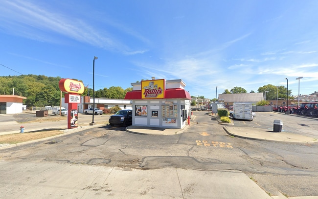
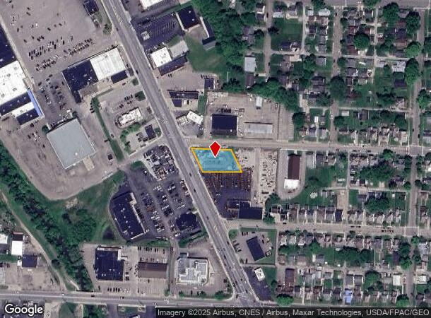
1028 N Memorial Dr, Lancaster, OH 43130
Current Lease Availabilities
NEARBY LISTINGS FOR SALE OR LEASE
Property Detail
1028 N Memorial Dr
05-32010-700
R 19 T 15 S 36 -56N-
Restaurantdrivein
Fairfield
X
Ohio
39045C0251G
0.37 AC
2024
Fairfield County
2024
Columbus
032000
Columbus, OH
625 SF
DEMOGRAPHICS near 1028 N Memorial Dr
1 Mile
3 Mile
5 Mile
2024 Total Population
11,940
47,809
56,755
2029 Population
12,906
51,527
61,055
Pop Growth 2024-2029
+ 8.09%
+ 7.78%
+ 7.58%
Average Age
40
41
41
2024 Total Households
4,998
19,914
22,914
HH Growth 2024-2029
+ 8.26%
+ 8.01%
+ 7.84%
Median Household Inc
$51,387
$57,061
$60,993
Avg Household Size
2.30
2.30
2.30
2024 Avg HH Vehicles
2.00
2.00
2.00
Median Home Value
$140,793
$168,525
$184,428
Median Year Built
1952
1965
1968
Nearby Places
Map Layers
Map Styles
 Street
 Aerial
- Restaurants
- Banks
- Shops
- Fitness
- Groceries
PUBLIC TRANSPORTATION
AIRPORT
Rickenbacker International
DRIVE
WALK
Distance
Rickenbacker International
37 min
22.3 mi
John Glenn Columbus International
DRIVE
WALK
Distance
John Glenn Columbus International
43 min
29.3 mi
Nearby Properties
Address
Land Use
TOTAL SIZE
Lot Size
Zoning
Address
Land Use
TOTAL SIZE
Lot Size
Zoning
519,532 SF
9.92 AC
Address
Land Use
TOTAL SIZE
Lot Size
Zoning
1,278,248 SF
65.57 AC
Address
Land Use
TOTAL SIZE
Lot Size
Zoning
111,535 SF
4.80 AC
Address
Land Use
TOTAL SIZE
Lot Size
Zoning
85,331 SF
18.94 AC
Address
Land Use
TOTAL SIZE
Lot Size
Zoning
44,800 SF
15.93 AC
Address
Land Use
TOTAL SIZE
Lot Size
Zoning
69,461 SF
13.72 AC
Address
Land Use
TOTAL SIZE
Lot Size
Zoning
45,633 SF
13.92 AC
Address
Land Use
TOTAL SIZE
Lot Size
Zoning
88,522 SF
36.77 AC
Address
Land Use
TOTAL SIZE
Lot Size
Zoning
88,522 SF
37.42 AC
Address
Land Use
TOTAL SIZE
Lot Size
Zoning
67,322 SF
16.45 AC
Address
Land Use
TOTAL SIZE
Lot Size
Zoning
56,826 SF
7.04 AC
Address
Land Use
TOTAL SIZE
Lot Size
Zoning
62,550 SF
14.82 AC
Address
Land Use
TOTAL SIZE
Lot Size
Zoning
155,985 SF
13.70 AC
Address
Land Use
TOTAL SIZE
Lot Size
Zoning
141,894 SF
68.74 AC
Address
Land Use
TOTAL SIZE
Lot Size
Zoning
229,660 SF
21.76 AC
Address
Land Use
TOTAL SIZE
Lot Size
Zoning
76,509 SF
7.21 AC
Address
Land Use
TOTAL SIZE
Lot Size
Zoning
34,020 SF
20.93 AC
Address
Land Use
TOTAL SIZE
Lot Size
Zoning
29,579 SF
6.77 AC
Address
Land Use
TOTAL SIZE
Lot Size
Zoning
177,448 SF
16.40 AC
Address
Land Use
TOTAL SIZE
Lot Size
Zoning
61,657 SF
10.45 AC
Address
Land Use
TOTAL SIZE
Lot Size
Zoning
201,304 SF
17.11 AC
Address
Land Use
TOTAL SIZE
Lot Size
Zoning
54,558 SF
11.24 AC
Address
Land Use
TOTAL SIZE
Lot Size
Zoning
126,928 SF
12.29 AC
Address
Land Use
TOTAL SIZE
Lot Size
Zoning
59,538 SF
22.24 AC
Address
Land Use
TOTAL SIZE
Lot Size
Zoning
573,376 SF
51.48 AC
Address
Land Use
TOTAL SIZE
Lot Size
Zoning
149,903 SF
43.98 AC
Address
Land Use
TOTAL SIZE
Lot Size
Zoning
68,156 SF
5.34 AC
Address
Land Use
TOTAL SIZE
Lot Size
Zoning
63,618 SF
4.14 AC
Address
Land Use
TOTAL SIZE
Lot Size
Zoning
91,478 SF
11.98 AC
Address
Land Use
TOTAL SIZE
Lot Size
Zoning
63,979 SF
6.80 AC
The World's #1 Commercial Real Estate Marketplace
Connect with us
© 2026 CoStar Group
The information above has been obtained from sources believed reliable. While we do not doubt its accuracy we have not verified it and make no guarantee, warranty or representation about it. It is your responsibility to independently confirm its accuracy and completeness. Any projections, opinions, assumptions, or estimates used are for example only and do not represent the current or future performance of the property. The value of this transaction to you depends on tax and other factors which should be evaluated by your tax, financial, and legal advisors. You and your advisors should conduct a careful, independent investigation of the property to determine to your satisfaction the suitability of the property for your needs.