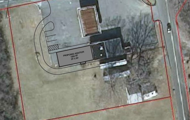
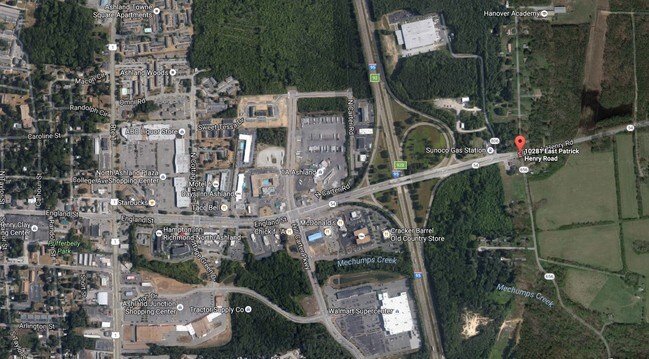
Property Record
10281 E Patrick Henry Rd, Ashland, VA 23005

Property Detail
10281 E Patrick Henry Rd
7880-51-0937
HWY 54 & RT 654
Commercialnec
Hanover
B-2
Virginia
B and X Area of moderate flood hazard, usually the area between the limits of the 100-year and 500-year floods.
1.19 AC
2025
I-95 Chamberlayne/NE
2025
Richmond VA
320602
Richmond, VA
1,668 SF
NEARBY LISTINGS FOR SALE OR LEASE
-
-
View all Ashland listings for lease on LoopNet.com
DEMOGRAPHICS near 10281 E Patrick Henry Rd
1 mile
3 mile
5 mile
2025 Total Population
2,861
12,615
24,004
2030 Population
2,973
13,134
25,022
Pop Growth 2025-2030
+ 3.91%
+ 4.11%
+ 4.24%
Average Age
38
40
41
2025 Total Households
1,183
4,643
8,941
HH Growth 2025-2030
+ 3.89%
+ 4.29%
+ 4.47%
Median Household Inc
$68,766
$94,843
$109,136
Avg Household Size
2.40
2.50
2.50
2025 Avg HH Vehicles
2.00
2.00
2.00
Median Home Value
$325,000
$387,236
$405,587
Median Year Built
1987
1984
1989
Nearby Places
Map Layers
Map Styles
 Street
 Aerial
Layers
 Traffic
 Biking
Places
Listings with unknown addresses are not visible on the map
- Restaurants
- Banks
- Shops
- Fitness
- Groceries
PUBLIC TRANSPORTATION
COMMUTER RAIL
Ashland Amtrak (Northeast Regional - Amtrak)
Drive
Walk
Distance
Ashland Amtrak (Northeast Regional - Amtrak)
4 min
1.6 mi
AIRPORT
Richmond International
Drive
Walk
Distance
Richmond International
32 min
24.5 mi
Freight Ports
Virginia Port Authority - Richmond
Drive
Walk
Distance
Virginia Port Authority - Richmond
33 min
24.2 mi
SALE & LEASE HISTORY
LISTING DATE
SALE/LEASE

Dec 09, 2016
For Lease
Nearby Properties
Address
Land Use
TOTAL SIZE
Lot Size
Zoning
Address
Land Use
TOTAL SIZE
Lot Size
Zoning
36.08 AC
HE
Address
Land Use
TOTAL SIZE
Lot Size
Zoning
26,583 SF
9 AC
HE
Address
Land Use
TOTAL SIZE
Lot Size
Zoning
30.94 AC
M-2
Address
Land Use
TOTAL SIZE
Lot Size
Zoning
3.60 AC
HE
Address
Land Use
TOTAL SIZE
Lot Size
Zoning
320,540 SF
18.50 AC
M-2
Address
Land Use
TOTAL SIZE
Lot Size
Zoning
194,598 SF
14.50 AC
R-5
Address
Land Use
TOTAL SIZE
Lot Size
Zoning
311,740 SF
43.40 AC
M-1
Address
Land Use
TOTAL SIZE
Lot Size
Zoning
280,900 SF
22.69 AC
M-1
Address
Land Use
TOTAL SIZE
Lot Size
Zoning
220,499 SF
19.01 AC
PSC
Address
Land Use
TOTAL SIZE
Lot Size
Zoning
293,114 SF
15.56 AC
M-2
Address
Land Use
TOTAL SIZE
Lot Size
Zoning
25.93 AC
M-2
Address
Land Use
TOTAL SIZE
Lot Size
Zoning
24.80 AC
M-2
Address
Land Use
TOTAL SIZE
Lot Size
Zoning
24.17 AC
M-1
Address
Land Use
TOTAL SIZE
Lot Size
Zoning
24.21 AC
RR-1
Address
Land Use
TOTAL SIZE
Lot Size
Zoning
215,072 SF
16.32 AC
M-2
Address
Land Use
TOTAL SIZE
Lot Size
Zoning
43.11 AC
PMH
Address
Land Use
TOTAL SIZE
Lot Size
Zoning
17.80 AC
B-3
Address
Land Use
TOTAL SIZE
Lot Size
Zoning
10.50 AC
R-2
Address
Land Use
TOTAL SIZE
Lot Size
Zoning
151,540 SF
21.15 AC
PSC
Address
Land Use
TOTAL SIZE
Lot Size
Zoning
15.83 AC
M-2
Address
Land Use
TOTAL SIZE
Lot Size
Zoning
14.43 AC
M-2
Address
Land Use
TOTAL SIZE
Lot Size
Zoning
23.97 AC
RR-1
Address
Land Use
TOTAL SIZE
Lot Size
Zoning
8.73 AC
M-2
Address
Land Use
TOTAL SIZE
Lot Size
Zoning
40,415 SF
29.10 AC
M-2
Address
Land Use
TOTAL SIZE
Lot Size
Zoning
66,910 SF
1.94 AC
B-2
Address
Land Use
TOTAL SIZE
Lot Size
Zoning
57,385 SF
2.38 AC
B-3
Address
Land Use
TOTAL SIZE
Lot Size
Zoning
133,536 SF
38.23 AC
M-3
Address
Land Use
TOTAL SIZE
Lot Size
Zoning
136,144 SF
6.27 AC
M-2
Address
Land Use
TOTAL SIZE
Lot Size
Zoning
48,622 SF
24.28 AC
POB
Address
Land Use
TOTAL SIZE
Lot Size
Zoning
12.49 AC
M-2
The World's #1 Commercial Real Estate Marketplace
Connect with us
© 2026 CoStar Group
The information above has been obtained from sources believed reliable. While we do not doubt its accuracy we have not verified it and make no guarantee, warranty or representation about it. It is your responsibility to independently confirm its accuracy and completeness. Any projections, opinions, assumptions, or estimates used are for example only and do not represent the current or future performance of the property. The value of this transaction to you depends on tax and other factors which should be evaluated by your tax, financial, and legal advisors. You and your advisors should conduct a careful, independent investigation of the property to determine to your satisfaction the suitability of the property for your needs.