Property Record
1029 Route 47 S, Rio Grande, NJ 08242
NEARBY LISTINGS FOR SALE OR LEASE
-
-
View all Rio Grande listings for sale on LoopNet.com
Property Detail
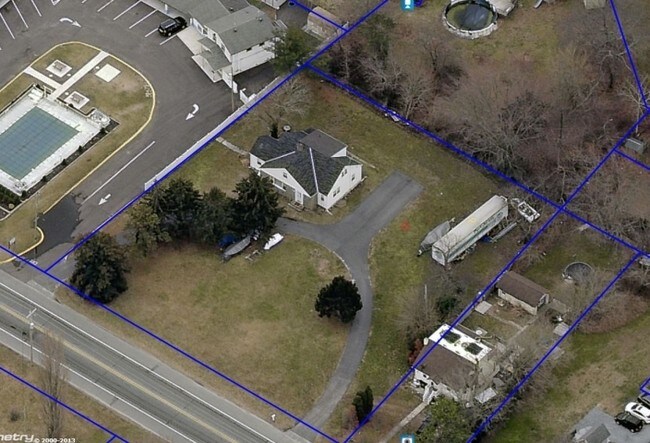
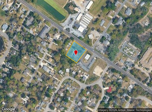
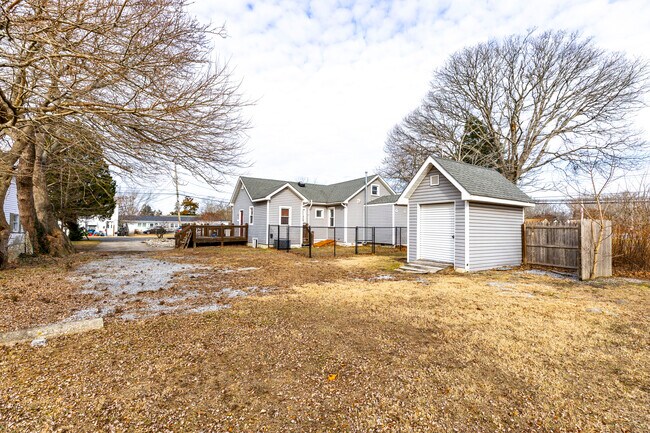
1029 Route 47 S
Ocean City, NJ
Cape May
06-01427-0000-00036
New Jersey
Sfr
0.87 AC
X
South Shore/Vineland
34009C0219F
Other Market Areas
1,879 SF
DEMOGRAPHICS near 1029 Route 47 S
1 Mile
3 Mile
5 Mile
2024 Total Population
1,181
12,898
36,702
2029 Population
1,016
11,506
35,183
Pop Growth 2024-2029
(13.97%)
(10.79%)
(4.14%)
Average Age
44
42
45
2024 Total Households
427
4,920
15,220
HH Growth 2024-2029
(16.63%)
(12.62%)
(5.01%)
Median Household Inc
$87,732
$71,547
$68,361
Avg Household Size
2.50
2.40
2.20
2024 Avg HH Vehicles
2.00
2.00
2.00
Median Home Value
$289,880
$242,791
$280,557
Median Year Built
1990
1976
1976
Nearby Places
Map Layers
Map Styles
 Street
 Aerial
- Restaurants
- Banks
- Shops
- Fitness
- Groceries
SALE & LEASE HISTORY
LISTING DATE
SALE/LEASE

Sep 24, 2016
For Sale
Feb 20, 2025
For Sale
Nearby Properties
Address
Land Use
TOTAL SIZE
Lot Size
Zoning
Address
Land Use
TOTAL SIZE
Lot Size
Zoning
32.39 AC
TC
Address
Land Use
TOTAL SIZE
Lot Size
Zoning
1,316 SF
16.41 AC
TR
Address
Land Use
TOTAL SIZE
Lot Size
Zoning
19.18 AC
TC
Address
Land Use
TOTAL SIZE
Lot Size
Zoning
12.73 AC
TC
Address
Land Use
TOTAL SIZE
Lot Size
Zoning
17.56 AC
TC
Address
Land Use
TOTAL SIZE
Lot Size
Zoning
1,944 SF
87.10 AC
Address
Land Use
TOTAL SIZE
Lot Size
Zoning
85.92 AC
Address
Land Use
TOTAL SIZE
Lot Size
Zoning
5.67 AC
TC
Address
Land Use
TOTAL SIZE
Lot Size
Zoning
3.71 AC
TC
Address
Land Use
TOTAL SIZE
Lot Size
Zoning
15.25 AC
TC
Address
Land Use
TOTAL SIZE
Lot Size
Zoning
73.03 AC
R-3
Address
Land Use
TOTAL SIZE
Lot Size
Zoning
5.71 AC
TB
Address
Land Use
TOTAL SIZE
Lot Size
Zoning
4.17 AC
TC
Address
Land Use
TOTAL SIZE
Lot Size
Zoning
3.71 AC
GB
Address
Land Use
TOTAL SIZE
Lot Size
Zoning
5.94 AC
TC
Address
Land Use
TOTAL SIZE
Lot Size
Zoning
Address
Land Use
TOTAL SIZE
Lot Size
Zoning
4.99 AC
TC
Address
Land Use
TOTAL SIZE
Lot Size
Zoning
85.15 AC
RC
Address
Land Use
TOTAL SIZE
Lot Size
Zoning
43.80 AC
TRRC
Address
Land Use
TOTAL SIZE
Lot Size
Zoning
204.70 AC
Address
Land Use
TOTAL SIZE
Lot Size
Zoning
5.90 AC
TB
Address
Land Use
TOTAL SIZE
Lot Size
Zoning
1.66 AC
TC
Address
Land Use
TOTAL SIZE
Lot Size
Zoning
68.95 AC
VCRC
Address
Land Use
TOTAL SIZE
Lot Size
Zoning
800 SF
19.09 AC
R-3
Address
Land Use
TOTAL SIZE
Lot Size
Zoning
15.90 AC
TC
Address
Land Use
TOTAL SIZE
Lot Size
Zoning
26.87 AC
Address
Land Use
TOTAL SIZE
Lot Size
Zoning
15.25 AC
TC
Address
Land Use
TOTAL SIZE
Lot Size
Zoning
2.71 AC
TC
Address
Land Use
TOTAL SIZE
Lot Size
Zoning
3.51 AC
TB
Address
Land Use
TOTAL SIZE
Lot Size
Zoning
5.06 AC
CD
The World's #1 Commercial Real Estate Marketplace
Connect with us
© 2025 CoStar Group
The information above has been obtained from sources believed reliable. While we do not doubt its accuracy we have not verified it and make no guarantee, warranty or representation about it. It is your responsibility to independently confirm its accuracy and completeness. Any projections, opinions, assumptions, or estimates used are for example only and do not represent the current or future performance of the property. The value of this transaction to you depends on tax and other factors which should be evaluated by your tax, financial, and legal advisors. You and your advisors should conduct a careful, independent investigation of the property to determine to your satisfaction the suitability of the property for your needs.