Property Record
103 E Walnut St, Saratoga, WY 82331
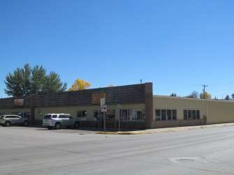


Property Detail
103 E Walnut St
17841412601000
LOTS 8, 9, 10, 11 & 12 BLK 8 RIVERSIDE ADDN. (BK 1355/114) TAX CODE 0255
Storebuilding
Carbon
AE The base floodplain where base flood elevations are provided. AE Zones are now used on new format FIRMs instead of A1-A30 Zones.
Wyoming
2024
8-9
2025
0.41 AC
968000
I-80 Corridor/Cheyenne
11,200 SF
Other Market Areas
NEARBY LISTINGS FOR SALE OR LEASE
-
-
View all Saratoga listings for sale on LoopNet.com
DEMOGRAPHICS near 103 E Walnut St
1 mile
3 mile
5 mile
2024 Total Population
1,260
1,383
1,420
2029 Population
1,155
1,268
1,301
Pop Growth 2024-2029
(8.33%)
(8.32%)
(8.38%)
Average Age
47
47
47
2024 Total Households
593
652
669
HH Growth 2024-2029
(8.26%)
(8.28%)
(8.22%)
Median Household Inc
$68,571
$68,529
$68,653
Avg Household Size
2.10
2.10
2.10
2024 Avg HH Vehicles
2.00
2.00
2.00
Median Home Value
$236,410
$234,331
$234,459
Median Year Built
1978
1978
1978
Nearby Places
Map Layers
Map Styles
 Street
 Aerial
Transit
 Traffic
 Biking
Places
Listings with unknown addresses are not visible on the map
- Restaurants
- Banks
- Shops
- Fitness
- Groceries
SALE & LEASE HISTORY
LISTING DATE
SALE/LEASE

Sep 23, 2016
For Sale
Sep 08, 2017
For Sale
Mar 28, 2018
For Sale
Jul 22, 2020
For Sale
Nearby Properties
Address
Land Use
TOTAL SIZE
Lot Size
Zoning
Address
Land Use
TOTAL SIZE
Lot Size
Zoning
39,092 SF
350.52 AC
Address
Land Use
TOTAL SIZE
Lot Size
Zoning
6,733 SF
4.93 AC
Address
Land Use
TOTAL SIZE
Lot Size
Zoning
4,286 SF
2,072.68 AC
Address
Land Use
TOTAL SIZE
Lot Size
Zoning
5,061 SF
0.41 AC
Address
Land Use
TOTAL SIZE
Lot Size
Zoning
12,284 SF
0.41 AC
Address
Land Use
TOTAL SIZE
Lot Size
Zoning
20,000 SF
1.31 AC
Address
Land Use
TOTAL SIZE
Lot Size
Zoning
6,766 SF
0.50 AC
Address
Land Use
TOTAL SIZE
Lot Size
Zoning
14,119 SF
1.16 AC
Address
Land Use
TOTAL SIZE
Lot Size
Zoning
16,092 SF
1.84 AC
Address
Land Use
TOTAL SIZE
Lot Size
Zoning
11,520 SF
1.21 AC
Address
Land Use
TOTAL SIZE
Lot Size
Zoning
16.02 AC
Address
Land Use
TOTAL SIZE
Lot Size
Zoning
8,040 SF
0.26 AC
Address
Land Use
TOTAL SIZE
Lot Size
Zoning
2,776 SF
631 AC
Address
Land Use
TOTAL SIZE
Lot Size
Zoning
14,048 SF
3 AC
Address
Land Use
TOTAL SIZE
Lot Size
Zoning
13,255 SF
927 AC
Address
Land Use
TOTAL SIZE
Lot Size
Zoning
12.96 AC
Address
Land Use
TOTAL SIZE
Lot Size
Zoning
Address
Land Use
TOTAL SIZE
Lot Size
Zoning
9.12 AC
Address
Land Use
TOTAL SIZE
Lot Size
Zoning
444 AC
Address
Land Use
TOTAL SIZE
Lot Size
Zoning
8,000 SF
0.66 AC
Address
Land Use
TOTAL SIZE
Lot Size
Zoning
10,904 SF
0.17 AC
Address
Land Use
TOTAL SIZE
Lot Size
Zoning
6.90 AC
Address
Land Use
TOTAL SIZE
Lot Size
Zoning
9,116 SF
0.50 AC
Address
Land Use
TOTAL SIZE
Lot Size
Zoning
12,677 SF
Address
Land Use
TOTAL SIZE
Lot Size
Zoning
10,356 SF
0.32 AC
Address
Land Use
TOTAL SIZE
Lot Size
Zoning
7,200 SF
3.39 AC
Address
Land Use
TOTAL SIZE
Lot Size
Zoning
4,188 SF
0.67 AC
Address
Land Use
TOTAL SIZE
Lot Size
Zoning
3,832 SF
0.50 AC
Address
Land Use
TOTAL SIZE
Lot Size
Zoning
5,879 SF
38.55 AC
Address
Land Use
TOTAL SIZE
Lot Size
Zoning
4,131 SF
0.36 AC
The World's #1 Commercial Real Estate Marketplace
Connect with us
© 2026 CoStar Group
The information above has been obtained from sources believed reliable. While we do not doubt its accuracy we have not verified it and make no guarantee, warranty or representation about it. It is your responsibility to independently confirm its accuracy and completeness. Any projections, opinions, assumptions, or estimates used are for example only and do not represent the current or future performance of the property. The value of this transaction to you depends on tax and other factors which should be evaluated by your tax, financial, and legal advisors. You and your advisors should conduct a careful, independent investigation of the property to determine to your satisfaction the suitability of the property for your needs.