Property Record
103 200Th Ave, Union Grove, WI 53182


NEARBY LISTINGS FOR SALE OR LEASE
-
-
View all Union Grove listings for lease on LoopNet.com
Property Detail
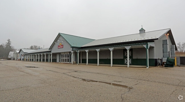
103 200Th Ave
Chicago-Naperville-Elgin, IL-IN-WI
Csm# 2033
45-4-221-052-0227
40-C-1 PARCEL 1 CSM #2033 DOC #1097067 PT NW 1/4 OF NW 1/4 SEC 5 T 2 R 21 3.25 AC EXC RD DOC #1081283 (1998 NEW COMB 45-4-221
Commercialnec
Kenosha
X
Wisconsin
55059C0041D
1
2024
3.25 AC
2024
Kenosha East
002802
Chicago
9,480 SF
DEMOGRAPHICS near 103 200Th Ave
1 Mile
3 Mile
5 Mile
2024 Total Population
1,740
7,368
11,422
2029 Population
1,787
7,368
11,377
Pop Growth 2024-2029
+ 2.70%
0.00%
(0.39%)
Average Age
37
41
42
2024 Total Households
675
2,638
4,253
HH Growth 2024-2029
+ 2.81%
+ 0.04%
(0.40%)
Median Household Inc
$91,844
$90,033
$90,381
Avg Household Size
2.50
2.40
2.50
2024 Avg HH Vehicles
2.00
2.00
2.00
Median Home Value
$253,684
$297,630
$320,602
Median Year Built
1991
1973
1972
Nearby Places
Map Layers
Map Styles
 Street
 Aerial
- Restaurants
- Banks
- Shops
- Fitness
- Groceries
PUBLIC TRANSPORTATION
COMMUTER RAIL
Sturtevant Amtrak Station (Hiawatha Service - Amtrak)
DRIVE
WALK
Distance
Sturtevant Amtrak Station (Hiawatha Service - Amtrak)
17 min
9.7 mi
AIRPORT
General Mitchell International
DRIVE
WALK
Distance
General Mitchell International
34 min
25.6 mi
Freight Ports
Port Milwaukee
DRIVE
WALK
Distance
Port Milwaukee
38 min
29.5 mi
SALE & LEASE HISTORY
LISTING DATE
SALE/LEASE

Jan 30, 2017
For Lease
Nearby Properties
Address
Land Use
TOTAL SIZE
Lot Size
Zoning
Address
Land Use
TOTAL SIZE
Lot Size
Zoning
7.12 AC
Address
Land Use
TOTAL SIZE
Lot Size
Zoning
4.15 AC
Address
Land Use
TOTAL SIZE
Lot Size
Zoning
3.04 AC
Address
Land Use
TOTAL SIZE
Lot Size
Zoning
5.54 AC
Address
Land Use
TOTAL SIZE
Lot Size
Zoning
0.05 AC
RM
Address
Land Use
TOTAL SIZE
Lot Size
Zoning
6.23 AC
I2
Address
Land Use
TOTAL SIZE
Lot Size
Zoning
20.02 AC
C1
Address
Land Use
TOTAL SIZE
Lot Size
Zoning
5.03 AC
P1
Address
Land Use
TOTAL SIZE
Lot Size
Zoning
8.38 AC
Address
Land Use
TOTAL SIZE
Lot Size
Zoning
8.38 AC
Address
Land Use
TOTAL SIZE
Lot Size
Zoning
76.91 AC
Address
Land Use
TOTAL SIZE
Lot Size
Zoning
0.80 AC
Address
Land Use
TOTAL SIZE
Lot Size
Zoning
4.55 AC
Address
Land Use
TOTAL SIZE
Lot Size
Zoning
4.61 AC
I2
Address
Land Use
TOTAL SIZE
Lot Size
Zoning
Address
Land Use
TOTAL SIZE
Lot Size
Zoning
12.12 AC
C1
Address
Land Use
TOTAL SIZE
Lot Size
Zoning
2.73 AC
C2
Address
Land Use
TOTAL SIZE
Lot Size
Zoning
30.53 AC
Address
Land Use
TOTAL SIZE
Lot Size
Zoning
151.16 AC
Address
Land Use
TOTAL SIZE
Lot Size
Zoning
0.07 AC
RM
Address
Land Use
TOTAL SIZE
Lot Size
Zoning
4.33 AC
I2
Address
Land Use
TOTAL SIZE
Lot Size
Zoning
0.98 AC
Address
Land Use
TOTAL SIZE
Lot Size
Zoning
0.07 AC
RM
Address
Land Use
TOTAL SIZE
Lot Size
Zoning
4.65 AC
MH
Address
Land Use
TOTAL SIZE
Lot Size
Zoning
0.29 AC
C1
Address
Land Use
TOTAL SIZE
Lot Size
Zoning
Address
Land Use
TOTAL SIZE
Lot Size
Zoning
2.32 AC
Address
Land Use
TOTAL SIZE
Lot Size
Zoning
0.06 AC
RM
Address
Land Use
TOTAL SIZE
Lot Size
Zoning
31.28 AC
Address
Land Use
TOTAL SIZE
Lot Size
Zoning
3.91 AC
The World's #1 Commercial Real Estate Marketplace
Connect with us
© 2025 CoStar Group
The information above has been obtained from sources believed reliable. While we do not doubt its accuracy we have not verified it and make no guarantee, warranty or representation about it. It is your responsibility to independently confirm its accuracy and completeness. Any projections, opinions, assumptions, or estimates used are for example only and do not represent the current or future performance of the property. The value of this transaction to you depends on tax and other factors which should be evaluated by your tax, financial, and legal advisors. You and your advisors should conduct a careful, independent investigation of the property to determine to your satisfaction the suitability of the property for your needs.