Property Record
103 Barnes Rd, Williamstown, KY 41097

Property Detail
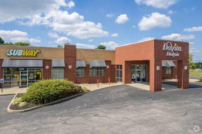
103 Barnes Rd
058-00-00-005.03
MED/RETAIL BLDG & 3.34 AC
Medicalclinic
GRANT
B and X Area of moderate flood hazard, usually the area between the limits of the 100-year and 500-year floods.
Kentucky
2025
3.34 AC
2025
Grant County
920302
Cincinnati/Dayton
16,545 SF
Cincinnati, OH-KY-IN
NEARBY LISTINGS FOR SALE OR LEASE
DEMOGRAPHICS near 103 Barnes Rd
1 mile
3 mile
5 mile
2025 Total Population
1,528
6,366
11,531
2030 Population
1,562
6,520
11,807
Pop Growth 2025-2030
+ 2.23%
+ 2.42%
+ 2.39%
Average Age
39
38
39
2025 Total Households
544
2,294
4,164
HH Growth 2025-2030
+ 2.21%
+ 2.40%
+ 2.45%
Median Household Inc
$68,749
$65,519
$69,690
Avg Household Size
2.60
2.60
2.70
2025 Avg HH Vehicles
2.00
2.00
2.00
Median Home Value
$192,338
$206,410
$212,024
Median Year Built
1975
1980
1986
Nearby Places
Map Layers
Map Styles
 Street
 Aerial
Transit
 Traffic
 Biking
Places
Listings with unknown addresses are not visible on the map
- Restaurants
- Banks
- Shops
- Fitness
- Groceries
PUBLIC TRANSPORTATION
AIRPORT
Cincinnati/Northern Kentucky International
Drive
Walk
Distance
Cincinnati/Northern Kentucky International
43 min
31.2 mi
Freight Ports
Port of Toledo
Drive
Walk
Distance
Port of Toledo
285 min
243.2 mi
SALE & LEASE HISTORY
LISTING DATE
SALE/LEASE

Sep 25, 2016
For Lease
Mar 21, 2024
For Sale
Jun 17, 2024
For Sale
Aug 18, 2017
For Lease
Nearby Properties
Address
Land Use
TOTAL SIZE
Lot Size
Zoning
Address
Land Use
TOTAL SIZE
Lot Size
Zoning
321,300 SF
28.87 AC
Address
Land Use
TOTAL SIZE
Lot Size
Zoning
154,743 SF
16.19 AC
COM
Address
Land Use
TOTAL SIZE
Lot Size
Zoning
3.03 AC
Address
Land Use
TOTAL SIZE
Lot Size
Zoning
Address
Land Use
TOTAL SIZE
Lot Size
Zoning
29,364 SF
9.94 AC
Address
Land Use
TOTAL SIZE
Lot Size
Zoning
2,400 SF
0.70 AC
COM
Address
Land Use
TOTAL SIZE
Lot Size
Zoning
Address
Land Use
TOTAL SIZE
Lot Size
Zoning
7.62 AC
Address
Land Use
TOTAL SIZE
Lot Size
Zoning
31.95 AC
Address
Land Use
TOTAL SIZE
Lot Size
Zoning
39,548 SF
1.29 AC
COM
Address
Land Use
TOTAL SIZE
Lot Size
Zoning
10.81 AC
Address
Land Use
TOTAL SIZE
Lot Size
Zoning
21,420 SF
4.83 AC
Address
Land Use
TOTAL SIZE
Lot Size
Zoning
3,350 SF
1 AC
COM
Address
Land Use
TOTAL SIZE
Lot Size
Zoning
100.80 AC
Address
Land Use
TOTAL SIZE
Lot Size
Zoning
6,272 SF
5.75 AC
Address
Land Use
TOTAL SIZE
Lot Size
Zoning
Address
Land Use
TOTAL SIZE
Lot Size
Zoning
4,230 SF
0.84 AC
COM
Address
Land Use
TOTAL SIZE
Lot Size
Zoning
35,685 SF
1.32 AC
COM
Address
Land Use
TOTAL SIZE
Lot Size
Zoning
14,142 SF
3 AC
Address
Land Use
TOTAL SIZE
Lot Size
Zoning
5,100 SF
0.85 AC
Address
Land Use
TOTAL SIZE
Lot Size
Zoning
15.35 AC
Address
Land Use
TOTAL SIZE
Lot Size
Zoning
276.50 AC
Address
Land Use
TOTAL SIZE
Lot Size
Zoning
17,022 SF
4.54 AC
Address
Land Use
TOTAL SIZE
Lot Size
Zoning
22,152 SF
1.13 AC
COM
Address
Land Use
TOTAL SIZE
Lot Size
Zoning
13,296 SF
4.31 AC
Address
Land Use
TOTAL SIZE
Lot Size
Zoning
127,735 SF
11.10 AC
Address
Land Use
TOTAL SIZE
Lot Size
Zoning
11.20 AC
Address
Land Use
TOTAL SIZE
Lot Size
Zoning
Address
Land Use
TOTAL SIZE
Lot Size
Zoning
1.40 AC
The World's #1 Commercial Real Estate Marketplace
Connect with us
© 2026 CoStar Group
The information above has been obtained from sources believed reliable. While we do not doubt its accuracy we have not verified it and make no guarantee, warranty or representation about it. It is your responsibility to independently confirm its accuracy and completeness. Any projections, opinions, assumptions, or estimates used are for example only and do not represent the current or future performance of the property. The value of this transaction to you depends on tax and other factors which should be evaluated by your tax, financial, and legal advisors. You and your advisors should conduct a careful, independent investigation of the property to determine to your satisfaction the suitability of the property for your needs.