Property Record
103 Mae Dr, Dallas, GA 30157


NEARBY LISTINGS FOR SALE OR LEASE
Property Detail
103 Mae Dr
Atlanta-Sandy Springs-Roswell, GA
Commercial Nh County
107.3.4.048.0000
REAL PROPERTY
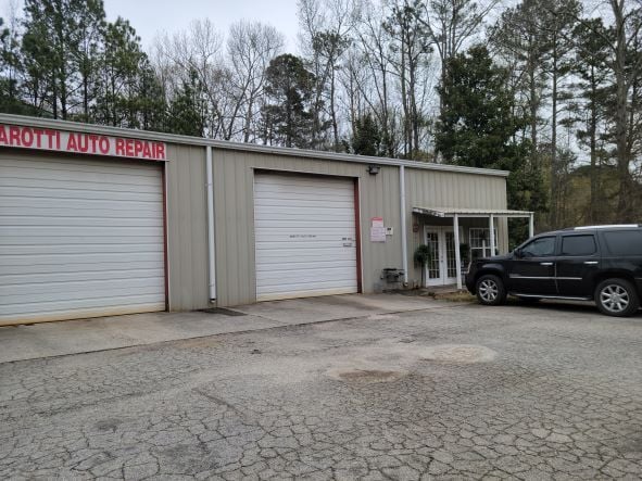
Autorepair
Paulding
X
Georgia
13223C0134C
42
2025
1.45 AC
2025
Paulding Cnty/Dallas
120203
Atlanta
3,760 SF
DEMOGRAPHICS near 103 Mae Dr
1 Mile
3 Mile
5 Mile
2024 Total Population
2,783
37,535
101,864
2029 Population
3,201
42,406
112,950
Pop Growth 2024-2029
+ 15.02%
+ 12.98%
+ 10.88%
Average Age
39
38
38
2024 Total Households
974
12,756
34,467
HH Growth 2024-2029
+ 15.20%
+ 13.15%
+ 11.14%
Median Household Inc
$104,778
$107,573
$108,790
Avg Household Size
2.90
2.90
2.90
2024 Avg HH Vehicles
2.00
2.00
2.00
Median Home Value
$249,454
$284,606
$309,428
Median Year Built
1996
1999
1999
Nearby Places
Map Layers
Map Styles
 Street
 Aerial
- Restaurants
- Banks
- Shops
- Fitness
- Groceries
PUBLIC TRANSPORTATION
AIRPORT
Hartsfield - Jackson Atlanta International
DRIVE
WALK
Distance
Hartsfield - Jackson Atlanta International
61 min
40.3 mi
Freight Ports
Georgia Ports - Savannah
DRIVE
WALK
Distance
Georgia Ports - Savannah
324 min
279.6 mi
SALE & LEASE HISTORY
LISTING DATE
SALE/LEASE

Mar 27, 2023
For Sale
Nearby Properties
Address
Land Use
TOTAL SIZE
Lot Size
Zoning
Address
Land Use
TOTAL SIZE
Lot Size
Zoning
46.05 AC
Address
Land Use
TOTAL SIZE
Lot Size
Zoning
126,638 SF
20.26 AC
R4
Address
Land Use
TOTAL SIZE
Lot Size
Zoning
25.10 AC
Address
Land Use
TOTAL SIZE
Lot Size
Zoning
187,435 SF
31.39 AC
R55
Address
Land Use
TOTAL SIZE
Lot Size
Zoning
37.28 AC
Address
Land Use
TOTAL SIZE
Lot Size
Zoning
203,706 SF
111.50 AC
Address
Land Use
TOTAL SIZE
Lot Size
Zoning
Address
Land Use
TOTAL SIZE
Lot Size
Zoning
Address
Land Use
TOTAL SIZE
Lot Size
Zoning
223,686 SF
30.20 AC
B2
Address
Land Use
TOTAL SIZE
Lot Size
Zoning
138,725 SF
11.66 AC
B2
Address
Land Use
TOTAL SIZE
Lot Size
Zoning
151,906 SF
21.07 AC
B2
Address
Land Use
TOTAL SIZE
Lot Size
Zoning
71,122 SF
30.70 AC
OMI
Address
Land Use
TOTAL SIZE
Lot Size
Zoning
Address
Land Use
TOTAL SIZE
Lot Size
Zoning
44,972 SF
7.81 AC
B2
Address
Land Use
TOTAL SIZE
Lot Size
Zoning
71,301 SF
3.88 AC
B1
Address
Land Use
TOTAL SIZE
Lot Size
Zoning
7.69 AC
Address
Land Use
TOTAL SIZE
Lot Size
Zoning
80,738 SF
10.30 AC
B2
Address
Land Use
TOTAL SIZE
Lot Size
Zoning
74,036 SF
23.20 AC
B2
Address
Land Use
TOTAL SIZE
Lot Size
Zoning
45,560 SF
4.06 AC
OMI
Address
Land Use
TOTAL SIZE
Lot Size
Zoning
78,156 SF
5.48 AC
Address
Land Use
TOTAL SIZE
Lot Size
Zoning
75,856 SF
10.06 AC
B2
Address
Land Use
TOTAL SIZE
Lot Size
Zoning
15,936 SF
2.62 AC
B2-0
Address
Land Use
TOTAL SIZE
Lot Size
Zoning
7.37 AC
Address
Land Use
TOTAL SIZE
Lot Size
Zoning
151.43 AC
Address
Land Use
TOTAL SIZE
Lot Size
Zoning
26,359 SF
18.38 AC
B2
Address
Land Use
TOTAL SIZE
Lot Size
Zoning
4,838 SF
3.42 AC
Address
Land Use
TOTAL SIZE
Lot Size
Zoning
80,476 SF
23.36 AC
B2
Address
Land Use
TOTAL SIZE
Lot Size
Zoning
28,886 SF
18 AC
Address
Land Use
TOTAL SIZE
Lot Size
Zoning
73,040 SF
5.96 AC
B2
Address
Land Use
TOTAL SIZE
Lot Size
Zoning
11,108 SF
1.89 AC
B1
The World's #1 Commercial Real Estate Marketplace
Connect with us
© 2026 CoStar Group
The information above has been obtained from sources believed reliable. While we do not doubt its accuracy we have not verified it and make no guarantee, warranty or representation about it. It is your responsibility to independently confirm its accuracy and completeness. Any projections, opinions, assumptions, or estimates used are for example only and do not represent the current or future performance of the property. The value of this transaction to you depends on tax and other factors which should be evaluated by your tax, financial, and legal advisors. You and your advisors should conduct a careful, independent investigation of the property to determine to your satisfaction the suitability of the property for your needs.