Property Record
103 Melville Loop, Chapel Hill, NC 27514
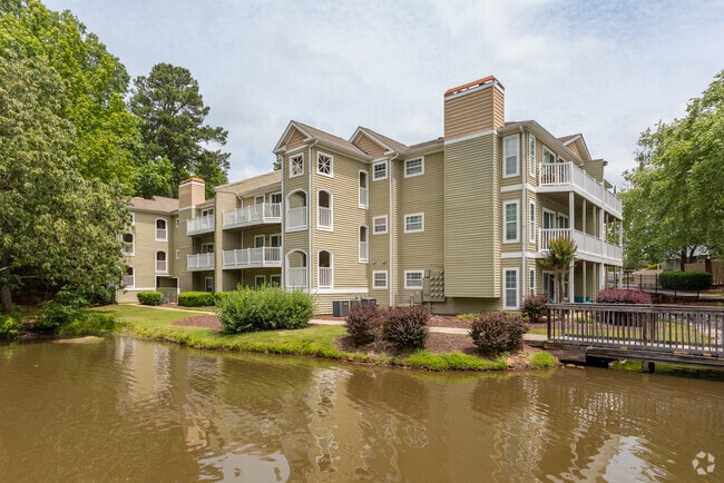

Property Detail
103 Melville Loop
9799590713
PH 1 SUMMEY BLDG SYSTEMS INC CH TP P40/45
Multifamilydwelling
Orange
R2R4
North Carolina
B and X Area of moderate flood hazard, usually the area between the limits of the 100-year and 500-year floods.
13.49 AC
2025
Chapel Hill East
2025
Raleigh/Durham
011206
Durham-Chapel Hill, NC
118,712 SF
NEARBY LISTINGS FOR SALE OR LEASE
DEMOGRAPHICS near 103 Melville Loop
1 mile
3 mile
5 mile
2025 Total Population
9,113
54,869
136,855
2030 Population
9,307
57,117
142,339
Pop Growth 2025-2030
+ 2.13%
+ 4.10%
+ 4.01%
Average Age
40
39
38
2025 Total Households
3,898
23,786
55,852
HH Growth 2025-2030
+ 2.15%
+ 4.49%
+ 4.44%
Median Household Inc
$87,526
$93,465
$93,547
Avg Household Size
2.20
2.20
2.20
2025 Avg HH Vehicles
2.00
2.00
2.00
Median Home Value
$521,438
$642,636
$588,386
Median Year Built
1989
1992
1990
Nearby Places
Map Layers
Map Styles
 Street
 Aerial
Layers
 Traffic
 Biking
Places
Listings with unknown addresses are not visible on the map
- Restaurants
- Banks
- Shops
- Fitness
- Groceries
PUBLIC TRANSPORTATION
AIRPORT
Raleigh-Durham International
Drive
Walk
Distance
Raleigh-Durham International
25 min
17.0 mi
Nearby Properties
Address
Land Use
TOTAL SIZE
Lot Size
Zoning
Address
Land Use
TOTAL SIZE
Lot Size
Zoning
216,220 SF
3.70 AC
CSD-C
Address
Land Use
TOTAL SIZE
Lot Size
Zoning
85,220 SF
20.34 AC
CSD-S1
Address
Land Use
TOTAL SIZE
Lot Size
Zoning
215,860 SF
12.28 AC
Address
Land Use
TOTAL SIZE
Lot Size
Zoning
116,223 SF
34.65 AC
Address
Land Use
TOTAL SIZE
Lot Size
Zoning
244,609 SF
2.72 AC
Address
Land Use
TOTAL SIZE
Lot Size
Zoning
193,344 SF
10.96 AC
MU(D)
Address
Land Use
TOTAL SIZE
Lot Size
Zoning
26,448 SF
22.07 AC
CSD-S1
Address
Land Use
TOTAL SIZE
Lot Size
Zoning
575,091 SF
3.21 AC
Address
Land Use
TOTAL SIZE
Lot Size
Zoning
24,183 SF
60.28 AC
PDR 9.280
Address
Land Use
TOTAL SIZE
Lot Size
Zoning
4,128 SF
678.68 AC
R1
Address
Land Use
TOTAL SIZE
Lot Size
Zoning
80,120 SF
101.81 AC
Address
Land Use
TOTAL SIZE
Lot Size
Zoning
419,416 SF
38.99 AC
CSD-S1
Address
Land Use
TOTAL SIZE
Lot Size
Zoning
55,318 SF
9.05 AC
R4
Address
Land Use
TOTAL SIZE
Lot Size
Zoning
238,990 SF
2.43 AC
Address
Land Use
TOTAL SIZE
Lot Size
Zoning
10,680 SF
33.33 AC
PDR 4.110
Address
Land Use
TOTAL SIZE
Lot Size
Zoning
134,448 SF
59.23 AC
Address
Land Use
TOTAL SIZE
Lot Size
Zoning
287,718 SF
4.97 AC
Address
Land Use
TOTAL SIZE
Lot Size
Zoning
150,677 SF
2.93 AC
Address
Land Use
TOTAL SIZE
Lot Size
Zoning
106,812 SF
19.25 AC
Address
Land Use
TOTAL SIZE
Lot Size
Zoning
280,771 SF
6.14 AC
RC(D)
Address
Land Use
TOTAL SIZE
Lot Size
Zoning
22,038 SF
24.63 AC
CSD-S2
Address
Land Use
TOTAL SIZE
Lot Size
Zoning
12,585 SF
57.79 AC
PDR 6.420
Address
Land Use
TOTAL SIZE
Lot Size
Zoning
25,016 SF
31.87 AC
CSD-S1
Address
Land Use
TOTAL SIZE
Lot Size
Zoning
6,720 SF
32.22 AC
PDR 4.000
Address
Land Use
TOTAL SIZE
Lot Size
Zoning
5,286 SF
32.32 AC
RS-M
Address
Land Use
TOTAL SIZE
Lot Size
Zoning
30,869 SF
20.01 AC
CSD-S2
Address
Land Use
TOTAL SIZE
Lot Size
Zoning
144,619 SF
3.22 AC
Address
Land Use
TOTAL SIZE
Lot Size
Zoning
38,300 SF
3.95 AC
MU(D)
Address
Land Use
TOTAL SIZE
Lot Size
Zoning
21,078 SF
227.43 AC
OI3R2
Address
Land Use
TOTAL SIZE
Lot Size
Zoning
17,202 SF
36.96 AC
RS-M
The World's #1 Commercial Real Estate Marketplace
Connect with us
© 2026 CoStar Group
The information above has been obtained from sources believed reliable. While we do not doubt its accuracy we have not verified it and make no guarantee, warranty or representation about it. It is your responsibility to independently confirm its accuracy and completeness. Any projections, opinions, assumptions, or estimates used are for example only and do not represent the current or future performance of the property. The value of this transaction to you depends on tax and other factors which should be evaluated by your tax, financial, and legal advisors. You and your advisors should conduct a careful, independent investigation of the property to determine to your satisfaction the suitability of the property for your needs.