Property Record
103 N Bud St, Broussard, LA 70518
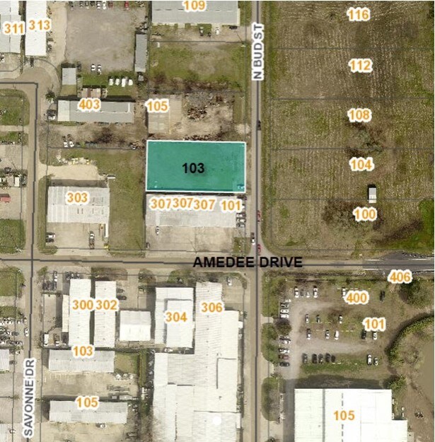

Property Detail
103 N Bud St
Lafayette, LA
LOT 4-A OF I-10 INDUSTRIAL PARK (0.438 AC)(2023-6268 PLAT)
6169021
LAFAYETTE
Industrialacreage
Louisiana
B and X Area of moderate flood hazard, usually the area between the limits of the 100-year and 500-year floods.
4
2025
0.44 AC
2025
Greater Lafayette
001425
Lafayette
NEARBY LISTINGS FOR SALE OR LEASE
DEMOGRAPHICS near 103 N Bud St
1 mile
3 mile
5 mile
2025 Total Population
2,509
51,902
123,917
2030 Population
2,606
54,238
129,594
Pop Growth 2025-2030
+ 3.87%
+ 4.50%
+ 4.58%
Average Age
37
39
39
2025 Total Households
1,048
21,936
52,011
HH Growth 2025-2030
+ 3.44%
+ 4.50%
+ 4.61%
Median Household Inc
$44,675
$46,415
$52,603
Avg Household Size
2.20
2.20
2.30
2025 Avg HH Vehicles
1.00
2.00
2.00
Median Home Value
$98,294
$187,919
$217,260
Median Year Built
1979
1978
1979
Nearby Places
Map Layers
Map Styles
 Street
 Aerial
Layers
 Traffic
 Biking
Places
Listings with unknown addresses are not visible on the map
- Restaurants
- Banks
- Shops
- Fitness
- Groceries
PUBLIC TRANSPORTATION
COMMUTER RAIL
Drive
Walk
Distance
9 min
4.1 mi
AIRPORT
Lafayette Regional/Paul Fournet Field
Drive
Walk
Distance
Lafayette Regional/Paul Fournet Field
13 min
6.5 mi
Freight Ports
Port of Iberia
Drive
Walk
Distance
Port of Iberia
39 min
27.4 mi
SALE & LEASE HISTORY
LISTING DATE
SALE/LEASE

Mar 19, 2019
For Sale
Nearby Properties
Address
Land Use
TOTAL SIZE
Lot Size
Zoning
Address
Land Use
TOTAL SIZE
Lot Size
Zoning
272,945 SF
21.64 AC
Address
Land Use
TOTAL SIZE
Lot Size
Zoning
231,380 SF
4.20 AC
Address
Land Use
TOTAL SIZE
Lot Size
Zoning
141,295 SF
28.09 AC
Address
Land Use
TOTAL SIZE
Lot Size
Zoning
443,758 SF
19.73 AC
Address
Land Use
TOTAL SIZE
Lot Size
Zoning
10.80 AC
Address
Land Use
TOTAL SIZE
Lot Size
Zoning
249,875 SF
29.76 AC
Address
Land Use
TOTAL SIZE
Lot Size
Zoning
96.54 AC
Address
Land Use
TOTAL SIZE
Lot Size
Zoning
221,760 SF
0.67 AC
Address
Land Use
TOTAL SIZE
Lot Size
Zoning
12.42 AC
Address
Land Use
TOTAL SIZE
Lot Size
Zoning
32.14 AC
Address
Land Use
TOTAL SIZE
Lot Size
Zoning
423,600 SF
24.16 AC
Address
Land Use
TOTAL SIZE
Lot Size
Zoning
15,386 SF
13.17 AC
Address
Land Use
TOTAL SIZE
Lot Size
Zoning
84,009 SF
6.90 AC
Address
Land Use
TOTAL SIZE
Lot Size
Zoning
47,249 SF
22.17 AC
Address
Land Use
TOTAL SIZE
Lot Size
Zoning
123,164 SF
2.11 AC
Address
Land Use
TOTAL SIZE
Lot Size
Zoning
250,211 SF
7.77 AC
Address
Land Use
TOTAL SIZE
Lot Size
Zoning
203,442 SF
39.38 AC
Address
Land Use
TOTAL SIZE
Lot Size
Zoning
87,868 SF
3.02 AC
Address
Land Use
TOTAL SIZE
Lot Size
Zoning
67,672 SF
10.18 AC
Address
Land Use
TOTAL SIZE
Lot Size
Zoning
95,667 SF
4.30 AC
Address
Land Use
TOTAL SIZE
Lot Size
Zoning
139,738 SF
11.05 AC
Address
Land Use
TOTAL SIZE
Lot Size
Zoning
150,000 SF
1 AC
Address
Land Use
TOTAL SIZE
Lot Size
Zoning
47,310 SF
3.80 AC
Address
Land Use
TOTAL SIZE
Lot Size
Zoning
Address
Land Use
TOTAL SIZE
Lot Size
Zoning
26,943 SF
4.30 AC
Address
Land Use
TOTAL SIZE
Lot Size
Zoning
162,100 SF
3.04 AC
Address
Land Use
TOTAL SIZE
Lot Size
Zoning
12,430 SF
10.18 AC
Address
Land Use
TOTAL SIZE
Lot Size
Zoning
194,632 SF
10.95 AC
Address
Land Use
TOTAL SIZE
Lot Size
Zoning
164,152 SF
3.31 AC
Address
Land Use
TOTAL SIZE
Lot Size
Zoning
The World's #1 Commercial Real Estate Marketplace
Connect with us
© 2026 CoStar Group
The information above has been obtained from sources believed reliable. While we do not doubt its accuracy we have not verified it and make no guarantee, warranty or representation about it. It is your responsibility to independently confirm its accuracy and completeness. Any projections, opinions, assumptions, or estimates used are for example only and do not represent the current or future performance of the property. The value of this transaction to you depends on tax and other factors which should be evaluated by your tax, financial, and legal advisors. You and your advisors should conduct a careful, independent investigation of the property to determine to your satisfaction the suitability of the property for your needs.