Property Record
103 N Main St, Norwood, NC 28128

NEARBY LISTINGS FOR SALE OR LEASE
-
-
View all Norwood listings for sale on LoopNet.com
Property Detail
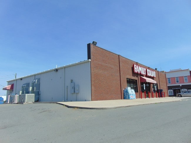
103 N Main St
6563-02-58-6642
Rogell E Hunsucker And Associates Inc
Wholesaleoutletdiscountstore
BLDG 103 N MAIN ST 656307115
X
Stanly
3710656300J
North Carolina
2025
0.72 AC
2025
Stanly County
931102
Charlotte
8,480 SF
Albemarle, NC
DEMOGRAPHICS near 103 N Main St
1 Mile
3 Mile
5 Mile
2024 Total Population
1,856
5,509
8,839
2029 Population
2,017
5,979
9,554
Pop Growth 2024-2029
+ 8.67%
+ 8.53%
+ 8.09%
Average Age
42
45
46
2024 Total Households
780
2,343
3,800
HH Growth 2024-2029
+ 8.59%
+ 8.28%
+ 7.79%
Median Household Inc
$51,795
$58,455
$61,351
Avg Household Size
2.30
2.30
2.30
2024 Avg HH Vehicles
2.00
2.00
2.00
Median Home Value
$150,310
$212,097
$229,044
Median Year Built
1968
1974
1977
Nearby Places
Map Layers
Map Styles
 Street
 Aerial
- Restaurants
- Banks
- Shops
- Fitness
- Groceries
PUBLIC TRANSPORTATION
AIRPORT
Concord-Padgett Regional
DRIVE
WALK
Distance
Concord-Padgett Regional
72 min
46.4 mi
SALE & LEASE HISTORY
LISTING DATE
SALE/LEASE

Sep 24, 2016
For Sale
Nearby Properties
Address
Land Use
TOTAL SIZE
Lot Size
Zoning
Address
Land Use
TOTAL SIZE
Lot Size
Zoning
90,552 SF
35.17 AC
Address
Land Use
TOTAL SIZE
Lot Size
Zoning
240,750 SF
27.62 AC
M-2
Address
Land Use
TOTAL SIZE
Lot Size
Zoning
39,583 SF
32.83 AC
R-20
Address
Land Use
TOTAL SIZE
Lot Size
Zoning
19,260 SF
6.31 AC
R-20
Address
Land Use
TOTAL SIZE
Lot Size
Zoning
22,960 SF
9.40 AC
R-20
Address
Land Use
TOTAL SIZE
Lot Size
Zoning
117.58 AC
Address
Land Use
TOTAL SIZE
Lot Size
Zoning
3,484 SF
7.13 AC
R-20
Address
Land Use
TOTAL SIZE
Lot Size
Zoning
7,056 SF
165.07 AC
R-20
Address
Land Use
TOTAL SIZE
Lot Size
Zoning
39,448 SF
4.49 AC
H-B
Address
Land Use
TOTAL SIZE
Lot Size
Zoning
487.19 AC
Address
Land Use
TOTAL SIZE
Lot Size
Zoning
77,920 SF
32.82 AC
M-2
Address
Land Use
TOTAL SIZE
Lot Size
Zoning
10,330 SF
46.91 AC
Address
Land Use
TOTAL SIZE
Lot Size
Zoning
17,527 SF
6.30 AC
R-A
Address
Land Use
TOTAL SIZE
Lot Size
Zoning
8,820 SF
15.32 AC
Address
Land Use
TOTAL SIZE
Lot Size
Zoning
30.76 AC
MULTIPLE
Address
Land Use
TOTAL SIZE
Lot Size
Zoning
4,615 SF
14.35 AC
Address
Land Use
TOTAL SIZE
Lot Size
Zoning
57.21 AC
MULTIPLE
Address
Land Use
TOTAL SIZE
Lot Size
Zoning
2,757 SF
10 AC
Address
Land Use
TOTAL SIZE
Lot Size
Zoning
60,720 SF
18.50 AC
M-2
Address
Land Use
TOTAL SIZE
Lot Size
Zoning
87,781 SF
12.02 AC
MULTIPLE
Address
Land Use
TOTAL SIZE
Lot Size
Zoning
15,576 SF
4.50 AC
R-10
Address
Land Use
TOTAL SIZE
Lot Size
Zoning
4,456 SF
0.76 AC
R-20
Address
Land Use
TOTAL SIZE
Lot Size
Zoning
39.68 AC
Address
Land Use
TOTAL SIZE
Lot Size
Zoning
6,435 SF
2.35 AC
Address
Land Use
TOTAL SIZE
Lot Size
Zoning
8,889 SF
3.40 AC
R-10
Address
Land Use
TOTAL SIZE
Lot Size
Zoning
5,120 SF
2.95 AC
MULTIPLE
Address
Land Use
TOTAL SIZE
Lot Size
Zoning
268,914 SF
20.77 AC
Address
Land Use
TOTAL SIZE
Lot Size
Zoning
5.09 AC
R-20
Address
Land Use
TOTAL SIZE
Lot Size
Zoning
11,596 SF
1.16 AC
C-B
Address
Land Use
TOTAL SIZE
Lot Size
Zoning
6,804 SF
1.30 AC
R-10
The World's #1 Commercial Real Estate Marketplace
Connect with us
© 2025 CoStar Group
The information above has been obtained from sources believed reliable. While we do not doubt its accuracy we have not verified it and make no guarantee, warranty or representation about it. It is your responsibility to independently confirm its accuracy and completeness. Any projections, opinions, assumptions, or estimates used are for example only and do not represent the current or future performance of the property. The value of this transaction to you depends on tax and other factors which should be evaluated by your tax, financial, and legal advisors. You and your advisors should conduct a careful, independent investigation of the property to determine to your satisfaction the suitability of the property for your needs.