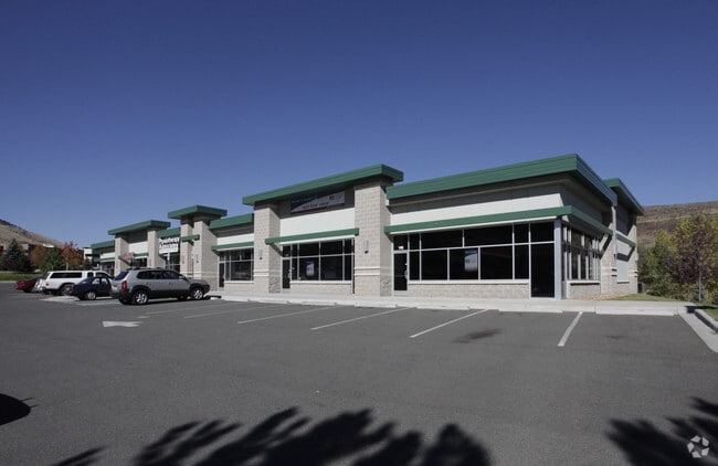
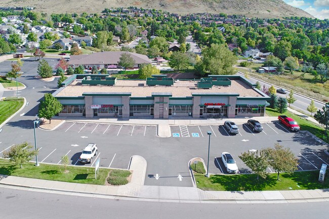
Property Record
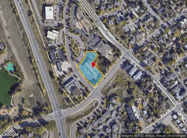
103 N Rubey Dr, Golden, CO 80403
NEARBY LISTINGS FOR SALE OR LEASE
Property Detail
103 N Rubey Dr
Denver-Aurora-Centennial, CO
Canyon Point Commercial Center Flg 2
30-282-10-015
SECTION 28 TOWNSHIP 03 RANGE 70 QTR NW SUBDIVISIONCD 108777 SUBDIVISIONNAME CANYON POINT COMMERCIAL CENTER FLG 2 BLOCK LOT 0001 SIZE: 46796 TRACT VALUE: 1.074
Commercialnec
Jefferson
X
Colorado
08059C0188G
1
2023
1.07 AC
2024
Northwest
009857
Denver
10,524 SF
DEMOGRAPHICS near 103 N Rubey Dr
1 Mile
3 Mile
5 Mile
2024 Total Population
8,285
21,277
58,402
2029 Population
8,325
21,264
57,963
Pop Growth 2024-2029
+ 0.48%
(0.06%)
(0.75%)
Average Age
39
39
41
2024 Total Households
3,326
8,021
22,953
HH Growth 2024-2029
+ 0.60%
+ 0.04%
(0.80%)
Median Household Inc
$92,246
$101,654
$113,979
Avg Household Size
2.20
2.30
2.40
2024 Avg HH Vehicles
2.00
2.00
2.00
Median Home Value
$726,470
$734,911
$719,598
Median Year Built
1990
1985
1987
Nearby Places
Map Layers
Map Styles
 Street
 Aerial
- Restaurants
- Banks
- Shops
- Fitness
- Groceries
PUBLIC TRANSPORTATION
COMMUTER RAIL
Wheat Ridge - Ward Station Track 1 (Union Station to Wheat Ridge Ward Station - Regional Transportation District)
DRIVE
WALK
Distance
Wheat Ridge - Ward Station Track 1 (Union Station to Wheat Ridge Ward Station - Regional Transportation District)
12 min
7.4 mi
Arvada Ridge Station Track 1 (Union Station to Wheat Ridge Ward Station - Regional Transportation District)
DRIVE
WALK
Distance
Arvada Ridge Station Track 1 (Union Station to Wheat Ridge Ward Station - Regional Transportation District)
13 min
8.4 mi
Freight Ports
Tulsa Port Of Catoosa
DRIVE
WALK
Distance
Tulsa Port Of Catoosa
743 min
721.5 mi
SALE & LEASE HISTORY
LISTING DATE
SALE/LEASE

Oct 12, 2016
For Lease
Oct 11, 2017
For Sale
Apr 25, 2018
For Lease
Nearby Properties
Address
Land Use
TOTAL SIZE
Lot Size
Zoning
Address
Land Use
TOTAL SIZE
Lot Size
Zoning
3,357,529 SF
32.87 AC
Address
Land Use
TOTAL SIZE
Lot Size
Zoning
420,482 SF
66.03 AC
Address
Land Use
TOTAL SIZE
Lot Size
Zoning
69,819 SF
1,402.21 AC
R1
Address
Land Use
TOTAL SIZE
Lot Size
Zoning
352,259 SF
17.94 AC
Address
Land Use
TOTAL SIZE
Lot Size
Zoning
589,966 SF
23.48 AC
Address
Land Use
TOTAL SIZE
Lot Size
Zoning
156,531 SF
8.20 AC
Address
Land Use
TOTAL SIZE
Lot Size
Zoning
188,554 SF
33.28 AC
Address
Land Use
TOTAL SIZE
Lot Size
Zoning
353,286 SF
14.49 AC
Address
Land Use
TOTAL SIZE
Lot Size
Zoning
198,147 SF
2.55 AC
Address
Land Use
TOTAL SIZE
Lot Size
Zoning
227,132 SF
11.95 AC
Address
Land Use
TOTAL SIZE
Lot Size
Zoning
1,115,227 SF
84.74 AC
I2
Address
Land Use
TOTAL SIZE
Lot Size
Zoning
192,500 SF
10.97 AC
Address
Land Use
TOTAL SIZE
Lot Size
Zoning
260,325 SF
13.70 AC
Address
Land Use
TOTAL SIZE
Lot Size
Zoning
350,722 SF
73.85 AC
R1
Address
Land Use
TOTAL SIZE
Lot Size
Zoning
454.79 AC
A2
Address
Land Use
TOTAL SIZE
Lot Size
Zoning
391,506 SF
10.02 AC
Address
Land Use
TOTAL SIZE
Lot Size
Zoning
68,773 SF
9.90 AC
Address
Land Use
TOTAL SIZE
Lot Size
Zoning
240,059 SF
58.36 AC
Address
Land Use
TOTAL SIZE
Lot Size
Zoning
67,473 SF
6.90 AC
Address
Land Use
TOTAL SIZE
Lot Size
Zoning
190,874 SF
17.36 AC
Address
Land Use
TOTAL SIZE
Lot Size
Zoning
90,663 SF
56.05 AC
Address
Land Use
TOTAL SIZE
Lot Size
Zoning
149,760 SF
8.64 AC
Address
Land Use
TOTAL SIZE
Lot Size
Zoning
64,883 SF
4.74 AC
Address
Land Use
TOTAL SIZE
Lot Size
Zoning
82,432 SF
1.62 AC
Address
Land Use
TOTAL SIZE
Lot Size
Zoning
72,164 SF
8 AC
R2
Address
Land Use
TOTAL SIZE
Lot Size
Zoning
68,500 SF
5.84 AC
Address
Land Use
TOTAL SIZE
Lot Size
Zoning
173,498 SF
42.86 AC
Address
Land Use
TOTAL SIZE
Lot Size
Zoning
180,193 SF
4.58 AC
Address
Land Use
TOTAL SIZE
Lot Size
Zoning
65,682 SF
6 AC
Address
Land Use
TOTAL SIZE
Lot Size
Zoning
282,265 SF
80.48 AC
I2
The World's #1 Commercial Real Estate Marketplace
Connect with us
© 2026 CoStar Group
The information above has been obtained from sources believed reliable. While we do not doubt its accuracy we have not verified it and make no guarantee, warranty or representation about it. It is your responsibility to independently confirm its accuracy and completeness. Any projections, opinions, assumptions, or estimates used are for example only and do not represent the current or future performance of the property. The value of this transaction to you depends on tax and other factors which should be evaluated by your tax, financial, and legal advisors. You and your advisors should conduct a careful, independent investigation of the property to determine to your satisfaction the suitability of the property for your needs.