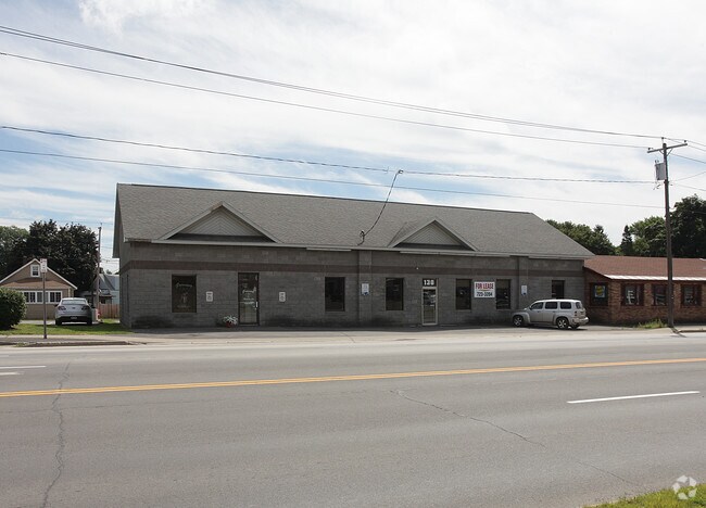
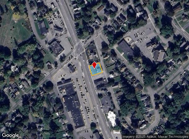
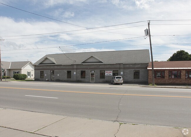
Property Record
103 Oriskany Blvd, Whitesboro, NY 13492
NEARBY LISTINGS FOR SALE OR LEASE
Property Detail
103 Oriskany Blvd
305-014-0002-033-000-0000
Oneida
Commercialofficeresidentialmixeduse
New York
X
33.000
36065C0731F
0.22 AC
2025
Outlying Oneida County
2024
Utica/Rome
023502
Utica-Rome, NY
3,223 SF
DEMOGRAPHICS near 103 Oriskany Blvd
1 Mile
3 Mile
5 Mile
2024 Total Population
6,828
39,328
100,490
2029 Population
6,712
38,701
98,473
Pop Growth 2024-2029
(1.70%)
(1.59%)
(2.01%)
Average Age
41
40
40
2024 Total Households
3,191
16,526
40,885
HH Growth 2024-2029
(1.91%)
(1.69%)
(2.04%)
Median Household Inc
$64,040
$51,963
$53,953
Avg Household Size
2.10
2.20
2.30
2024 Avg HH Vehicles
2.00
1.00
1.00
Median Home Value
$154,985
$148,132
$153,705
Median Year Built
1953
1950
1952
Nearby Places
- Restaurants
- Banks
- Shops
- Fitness
- Groceries
PUBLIC TRANSPORTATION
COMMUTER RAIL
Utica Amtrak Station (Empire Service - Amtrak, Lake Shore Limited - Amtrak, Maple Leaf - Amtrak)
DRIVE
WALK
Distance
Utica Amtrak Station (Empire Service - Amtrak, Lake Shore Limited - Amtrak, Maple Leaf - Amtrak)
6 min
4.0 mi
Utica (Toronto - New York - VIA Rail)
DRIVE
WALK
Distance
Utica (Toronto - New York - VIA Rail)
7 min
4.1 mi
Freight Ports
Albany, NY Port
DRIVE
WALK
Distance
Albany, NY Port
119 min
98.5 mi
Nearby Properties
Address
Land Use
TOTAL SIZE
Lot Size
Zoning
Address
Land Use
TOTAL SIZE
Lot Size
Zoning
271,000 SF
16.50 AC
Address
Land Use
TOTAL SIZE
Lot Size
Zoning
446,163 SF
24.07 AC
05 - COMME
Address
Land Use
TOTAL SIZE
Lot Size
Zoning
74,414 SF
45.44 AC
01
Address
Land Use
TOTAL SIZE
Lot Size
Zoning
279,786 SF
121 AC
Address
Land Use
TOTAL SIZE
Lot Size
Zoning
236,597 SF
2.10 AC
Address
Land Use
TOTAL SIZE
Lot Size
Zoning
109,000 SF
13.56 AC
01 - NOT Z
Address
Land Use
TOTAL SIZE
Lot Size
Zoning
58,650 SF
1,024.59 AC
05 - COMME
Address
Land Use
TOTAL SIZE
Lot Size
Zoning
50,000 SF
4.20 AC
05 - COMME
Address
Land Use
TOTAL SIZE
Lot Size
Zoning
208,247 SF
20.43 AC
Address
Land Use
TOTAL SIZE
Lot Size
Zoning
131,534 SF
16 AC
05 - COMME
Address
Land Use
TOTAL SIZE
Lot Size
Zoning
1,085,454 SF
101.28 AC
05 - COMME
Address
Land Use
TOTAL SIZE
Lot Size
Zoning
180,605 SF
40.60 AC
Address
Land Use
TOTAL SIZE
Lot Size
Zoning
25,860 SF
18.45 AC
05 - COMME
Address
Land Use
TOTAL SIZE
Lot Size
Zoning
55,172 SF
81.24 AC
Address
Land Use
TOTAL SIZE
Lot Size
Zoning
129,456 SF
15.02 AC
01 - NOT Z
Address
Land Use
TOTAL SIZE
Lot Size
Zoning
55,916 SF
4.50 AC
Address
Land Use
TOTAL SIZE
Lot Size
Zoning
292,687 SF
41.33 AC
05 - COMME
Address
Land Use
TOTAL SIZE
Lot Size
Zoning
98,900 SF
28.20 AC
05 - COMME
Address
Land Use
TOTAL SIZE
Lot Size
Zoning
137,933 SF
15.13 AC
Address
Land Use
TOTAL SIZE
Lot Size
Zoning
94,050 SF
22.58 AC
05 - COMME
Address
Land Use
TOTAL SIZE
Lot Size
Zoning
77,584 SF
8 AC
Address
Land Use
TOTAL SIZE
Lot Size
Zoning
3,472 SF
1.06 AC
Address
Land Use
TOTAL SIZE
Lot Size
Zoning
8.31 AC
05
Address
Land Use
TOTAL SIZE
Lot Size
Zoning
118,048 SF
32.59 AC
05 - COMME
Address
Land Use
TOTAL SIZE
Lot Size
Zoning
128,500 SF
19.10 AC
05 - COMME
Address
Land Use
TOTAL SIZE
Lot Size
Zoning
47,732 SF
0.86 AC
DS
Address
Land Use
TOTAL SIZE
Lot Size
Zoning
57,170 SF
4.40 AC
Address
Land Use
TOTAL SIZE
Lot Size
Zoning
31,023 SF
1.72 AC
Address
Land Use
TOTAL SIZE
Lot Size
Zoning
88,408 SF
6.83 AC
1
Address
Land Use
TOTAL SIZE
Lot Size
Zoning
83,035 SF
1.77 AC
05 - COMME
The World's #1 Commercial Real Estate Marketplace
Connect with us
© 2025 CoStar Group
The information above has been obtained from sources believed reliable. While we do not doubt its accuracy we have not verified it and make no guarantee, warranty or representation about it. It is your responsibility to independently confirm its accuracy and completeness. Any projections, opinions, assumptions, or estimates used are for example only and do not represent the current or future performance of the property. The value of this transaction to you depends on tax and other factors which should be evaluated by your tax, financial, and legal advisors. You and your advisors should conduct a careful, independent investigation of the property to determine to your satisfaction the suitability of the property for your needs.