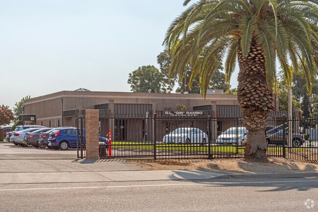
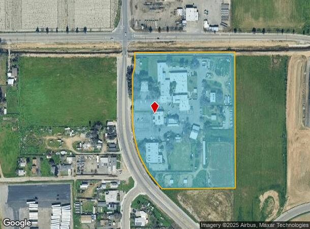
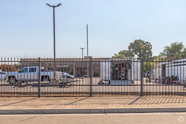
Property Record
103 S Hughes Ave, Fresno, CA 93706
NEARBY LISTINGS FOR SALE OR LEASE
Property Detail
103 S Hughes Ave
458-060-52
11.49 AC IN LOT 8 SUBD OF SEC 6 T14R20
Industrialgeneral
Fresno
A
California
06019C2105H
8
2025
11.46 AC
2025
Southwest Fresno
000702
Fresno
60,438 SF
Fresno, CA
DEMOGRAPHICS near 103 S Hughes Ave
1 Mile
3 Mile
5 Mile
2024 Total Population
3,051
92,439
254,056
2029 Population
3,101
93,942
258,535
Pop Growth 2024-2029
+ 1.64%
+ 1.63%
+ 1.76%
Average Age
35
35
35
2024 Total Households
835
29,178
77,902
HH Growth 2024-2029
+ 1.68%
+ 1.64%
+ 1.78%
Median Household Inc
$32,897
$42,497
$46,665
Avg Household Size
3.30
2.90
3.10
2024 Avg HH Vehicles
2.00
2.00
2.00
Median Home Value
$142,105
$247,843
$253,810
Median Year Built
1963
1963
1965
Nearby Places
Map Layers
Map Styles
 Street
 Aerial
- Restaurants
- Banks
- Shops
- Fitness
- Groceries
PUBLIC TRANSPORTATION
COMMUTER RAIL
Fresno (San Joaquins - Amtrak)
DRIVE
WALK
Distance
Fresno (San Joaquins - Amtrak)
7 min
3.7 mi
AIRPORT
Fresno Yosemite International
DRIVE
WALK
Distance
Fresno Yosemite International
14 min
9.6 mi
Freight Ports
Port of Stockton
DRIVE
WALK
Distance
Port of Stockton
149 min
126.3 mi
Nearby Properties
Address
Land Use
TOTAL SIZE
Lot Size
Zoning
Address
Land Use
TOTAL SIZE
Lot Size
Zoning
534,993 SF
5.23 AC
CP
Address
Land Use
TOTAL SIZE
Lot Size
Zoning
0.01 AC
P
Address
Land Use
TOTAL SIZE
Lot Size
Zoning
288,597 SF
1.18 AC
C4
Address
Land Use
TOTAL SIZE
Lot Size
Zoning
184,130 SF
1.87 AC
PI
Address
Land Use
TOTAL SIZE
Lot Size
Zoning
141,959 SF
35.39 AC
SPLIT
Address
Land Use
TOTAL SIZE
Lot Size
Zoning
101,510 SF
3.37 AC
CM
Address
Land Use
TOTAL SIZE
Lot Size
Zoning
471,760 SF
1.98 AC
CP
Address
Land Use
TOTAL SIZE
Lot Size
Zoning
213,874 SF
4.17 AC
SPLIT
Address
Land Use
TOTAL SIZE
Lot Size
Zoning
206,766 SF
17.11 AC
R2
Address
Land Use
TOTAL SIZE
Lot Size
Zoning
61,575 SF
3.50 AC
SPLIT
Address
Land Use
TOTAL SIZE
Lot Size
Zoning
79,518 SF
2.03 AC
R4
Address
Land Use
TOTAL SIZE
Lot Size
Zoning
480,570 SF
2.98 AC
P
Address
Land Use
TOTAL SIZE
Lot Size
Zoning
96,012 SF
1.33 AC
C4
Address
Land Use
TOTAL SIZE
Lot Size
Zoning
82,096 SF
0.26 AC
C4
Address
Land Use
TOTAL SIZE
Lot Size
Zoning
96,012 SF
0.60 AC
C4
Address
Land Use
TOTAL SIZE
Lot Size
Zoning
159,822 SF
9.67 AC
R2
Address
Land Use
TOTAL SIZE
Lot Size
Zoning
89,097 SF
0.63 AC
CC
Address
Land Use
TOTAL SIZE
Lot Size
Zoning
91,517 SF
1.80 AC
SPLIT
Address
Land Use
TOTAL SIZE
Lot Size
Zoning
108,017 SF
2.91 AC
CM
Address
Land Use
TOTAL SIZE
Lot Size
Zoning
372,640 SF
4.35 AC
CP
Address
Land Use
TOTAL SIZE
Lot Size
Zoning
37,017 SF
1.19 AC
CM
Address
Land Use
TOTAL SIZE
Lot Size
Zoning
71,384 SF
6.34 AC
IL
Address
Land Use
TOTAL SIZE
Lot Size
Zoning
83,622 SF
3.98 AC
M1
Address
Land Use
TOTAL SIZE
Lot Size
Zoning
106,740 SF
63.59 AC
AE20
Address
Land Use
TOTAL SIZE
Lot Size
Zoning
32,156 SF
2.60 AC
C6
Address
Land Use
TOTAL SIZE
Lot Size
Zoning
130,053 SF
0.69 AC
C4
Address
Land Use
TOTAL SIZE
Lot Size
Zoning
80,966 SF
8.91 AC
R2
Address
Land Use
TOTAL SIZE
Lot Size
Zoning
103,088 SF
5.41 AC
R3
Address
Land Use
TOTAL SIZE
Lot Size
Zoning
113,419 SF
1.26 AC
C4
Address
Land Use
TOTAL SIZE
Lot Size
Zoning
88,718 SF
1.64 AC
C4
The World's #1 Commercial Real Estate Marketplace
Connect with us
© 2026 CoStar Group
The information above has been obtained from sources believed reliable. While we do not doubt its accuracy we have not verified it and make no guarantee, warranty or representation about it. It is your responsibility to independently confirm its accuracy and completeness. Any projections, opinions, assumptions, or estimates used are for example only and do not represent the current or future performance of the property. The value of this transaction to you depends on tax and other factors which should be evaluated by your tax, financial, and legal advisors. You and your advisors should conduct a careful, independent investigation of the property to determine to your satisfaction the suitability of the property for your needs.