Property Record
103 S Stuart Place Rd, Harlingen, TX 78552
NEARBY LISTINGS FOR SALE OR LEASE
-
-
View all Harlingen listings for lease on LoopNet.com
Property Detail
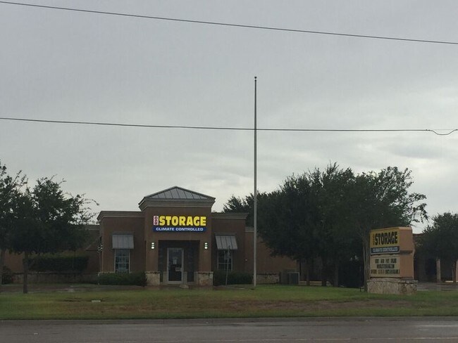
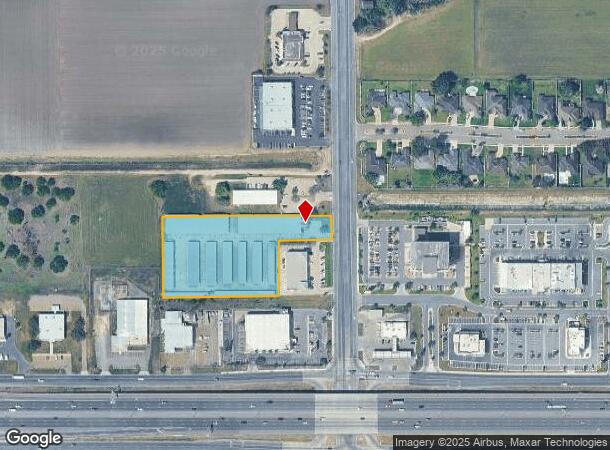
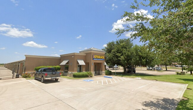
103 S Stuart Place Rd
Brownsville-Harlingen, TX
East Porte Centre Subdivision No 2
984229-0010-001000
LOS TRES COMPADRES SUBD BLK 1 LOT 1 (CAB 1 SLOT 2335-A CCMR) & 66.32 SF OUT OF LOT 1 BLK 1 ALTAS PALMAS ANIMAL CLINIC SUB, 3.0654 AC
Commercialnec
Cameron
X
Texas
48061C0250F
1
2024
3.07 AC
2025
Outlying Cameron County
010405
Brownsville/Harlingen
66,200 SF
DEMOGRAPHICS near 103 S Stuart Place Rd
1 Mile
3 Mile
5 Mile
2024 Total Population
4,636
33,048
79,835
2029 Population
4,770
34,035
81,857
Pop Growth 2024-2029
+ 2.89%
+ 2.99%
+ 2.53%
Average Age
43
38
37
2024 Total Households
1,795
11,285
27,022
HH Growth 2024-2029
+ 2.79%
+ 3.06%
+ 2.58%
Median Household Inc
$63,128
$60,391
$49,781
Avg Household Size
2.50
2.90
2.90
2024 Avg HH Vehicles
2.00
2.00
2.00
Median Home Value
$156,984
$128,108
$98,947
Median Year Built
1988
1994
1987
Nearby Places
Map Layers
Map Styles
 Street
 Aerial
- Restaurants
- Banks
- Shops
- Fitness
- Groceries
PUBLIC TRANSPORTATION
AIRPORT
Valley International
DRIVE
WALK
Distance
Valley International
15 min
8.9 mi
Brownsville/South Padre Island International
DRIVE
WALK
Distance
Brownsville/South Padre Island International
40 min
30.9 mi
McAllen International
DRIVE
WALK
Distance
McAllen International
39 min
32.4 mi
Freight Ports
Port of Brownsville
DRIVE
WALK
Distance
Port of Brownsville
33 min
28.5 mi
SALE & LEASE HISTORY
LISTING DATE
SALE/LEASE

May 02, 2025
For Lease
Nearby Properties
Address
Land Use
TOTAL SIZE
Lot Size
Zoning
Address
Land Use
TOTAL SIZE
Lot Size
Zoning
246,234 SF
16.40 AC
Address
Land Use
TOTAL SIZE
Lot Size
Zoning
171,714 SF
16.03 AC
C
Address
Land Use
TOTAL SIZE
Lot Size
Zoning
74,848 SF
2.30 AC
Address
Land Use
TOTAL SIZE
Lot Size
Zoning
391,617 SF
23.20 AC
C
Address
Land Use
TOTAL SIZE
Lot Size
Zoning
41,182 SF
34.14 AC
M-R
Address
Land Use
TOTAL SIZE
Lot Size
Zoning
176,365 SF
14.65 AC
Address
Land Use
TOTAL SIZE
Lot Size
Zoning
135,258 SF
4.26 AC
C
Address
Land Use
TOTAL SIZE
Lot Size
Zoning
72,063 SF
2.29 AC
Address
Land Use
TOTAL SIZE
Lot Size
Zoning
152,724 SF
17.78 AC
Address
Land Use
TOTAL SIZE
Lot Size
Zoning
63,450 SF
2.88 AC
Address
Land Use
TOTAL SIZE
Lot Size
Zoning
13,924 SF
31.33 AC
C
Address
Land Use
TOTAL SIZE
Lot Size
Zoning
177,812 SF
21.40 AC
C
Address
Land Use
TOTAL SIZE
Lot Size
Zoning
41,370 SF
3.40 AC
C
Address
Land Use
TOTAL SIZE
Lot Size
Zoning
51,748 SF
10 AC
Address
Land Use
TOTAL SIZE
Lot Size
Zoning
63,381 SF
3.15 AC
Address
Land Use
TOTAL SIZE
Lot Size
Zoning
81,569 SF
36.61 AC
Address
Land Use
TOTAL SIZE
Lot Size
Zoning
91,630 SF
11.17 AC
Address
Land Use
TOTAL SIZE
Lot Size
Zoning
89,508 SF
9.90 AC
Address
Land Use
TOTAL SIZE
Lot Size
Zoning
47,539 SF
8.77 AC
C
Address
Land Use
TOTAL SIZE
Lot Size
Zoning
134,367 SF
14.42 AC
Address
Land Use
TOTAL SIZE
Lot Size
Zoning
79,466 SF
6.23 AC
C
Address
Land Use
TOTAL SIZE
Lot Size
Zoning
68,826 SF
6.27 AC
Address
Land Use
TOTAL SIZE
Lot Size
Zoning
116,913 SF
8.44 AC
C
Address
Land Use
TOTAL SIZE
Lot Size
Zoning
77,077 SF
5.20 AC
Address
Land Use
TOTAL SIZE
Lot Size
Zoning
50,659 SF
6.43 AC
Address
Land Use
TOTAL SIZE
Lot Size
Zoning
20.64 AC
C
Address
Land Use
TOTAL SIZE
Lot Size
Zoning
18,016 SF
1.70 AC
Address
Land Use
TOTAL SIZE
Lot Size
Zoning
107,881 SF
20 AC
AU
Address
Land Use
TOTAL SIZE
Lot Size
Zoning
60,050 SF
1.98 AC
Address
Land Use
TOTAL SIZE
Lot Size
Zoning
47,388 SF
11.64 AC
The World's #1 Commercial Real Estate Marketplace
Connect with us
© 2025 CoStar Group
The information above has been obtained from sources believed reliable. While we do not doubt its accuracy we have not verified it and make no guarantee, warranty or representation about it. It is your responsibility to independently confirm its accuracy and completeness. Any projections, opinions, assumptions, or estimates used are for example only and do not represent the current or future performance of the property. The value of this transaction to you depends on tax and other factors which should be evaluated by your tax, financial, and legal advisors. You and your advisors should conduct a careful, independent investigation of the property to determine to your satisfaction the suitability of the property for your needs.