Property Record
103 Underwood Rd, Fletcher, NC 28732


NEARBY LISTINGS FOR SALE OR LEASE
Property Detail
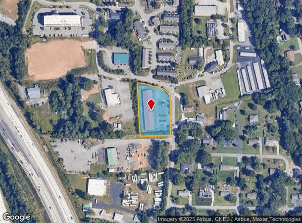
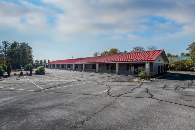
103 Underwood Rd
Asheville, NC
Underwood Road
9975897
SHOOK PROP SLD5140 LO5 PLSLD-5140
Regionalshoppingcenterormallwithanchorstore
Henderson
X
North Carolina
3700964300K
8581
2024
1.47 AC
2025
Henderson County
930600
Asheville
12,500 SF
DEMOGRAPHICS near 103 Underwood Rd
1 Mile
3 Mile
5 Mile
2024 Total Population
2,378
25,935
59,519
2029 Population
2,449
26,893
61,879
Pop Growth 2024-2029
+ 2.99%
+ 3.69%
+ 3.97%
Average Age
43
41
43
2024 Total Households
1,016
10,678
25,328
HH Growth 2024-2029
+ 3.05%
+ 3.45%
+ 3.65%
Median Household Inc
$67,227
$69,771
$72,795
Avg Household Size
2.30
2.40
2.30
2024 Avg HH Vehicles
2.00
2.00
2.00
Median Home Value
$289,864
$303,659
$352,298
Median Year Built
1995
1996
1996
Nearby Places
Map Layers
Map Styles
 Street
 Aerial
- Restaurants
- Banks
- Shops
- Fitness
- Groceries
PUBLIC TRANSPORTATION
AIRPORT
Asheville Regional
DRIVE
WALK
Distance
Asheville Regional
4 min
1.2 mi
SALE & LEASE HISTORY
LISTING DATE
SALE/LEASE

Oct 04, 2016
For Lease
Jul 30, 2021
For Lease
Aug 10, 2020
For Lease
Nearby Properties
Address
Land Use
TOTAL SIZE
Lot Size
Zoning
Address
Land Use
TOTAL SIZE
Lot Size
Zoning
107,063 SF
567.34 AC
AI
Address
Land Use
TOTAL SIZE
Lot Size
Zoning
281,505 SF
38.35 AC
10000070~M
Address
Land Use
TOTAL SIZE
Lot Size
Zoning
85,103 SF
11.69 AC
RES EXP
Address
Land Use
TOTAL SIZE
Lot Size
Zoning
107,408 SF
21.92 AC
R-3
Address
Land Use
TOTAL SIZE
Lot Size
Zoning
198,705 SF
32.46 AC
HB
Address
Land Use
TOTAL SIZE
Lot Size
Zoning
73,420 SF
10.24 AC
RM16
Address
Land Use
TOTAL SIZE
Lot Size
Zoning
481,731 SF
86.32 AC
1009658~I
Address
Land Use
TOTAL SIZE
Lot Size
Zoning
21.70 AC
10005690~M
Address
Land Use
TOTAL SIZE
Lot Size
Zoning
3,466 SF
11.32 AC
10000832~M
Address
Land Use
TOTAL SIZE
Lot Size
Zoning
4,839 SF
9.46 AC
10002512~C
Address
Land Use
TOTAL SIZE
Lot Size
Zoning
92,772 SF
12.30 AC
R-2
Address
Land Use
TOTAL SIZE
Lot Size
Zoning
899,676 SF
46.99 AC
1006235~M-
Address
Land Use
TOTAL SIZE
Lot Size
Zoning
43,882 SF
9.71 AC
1016337~C1
Address
Land Use
TOTAL SIZE
Lot Size
Zoning
24.83 AC
1012291~M-
Address
Land Use
TOTAL SIZE
Lot Size
Zoning
365,659 SF
38.28 AC
9958527~M-
Address
Land Use
TOTAL SIZE
Lot Size
Zoning
86,393 SF
15.44 AC
PS
Address
Land Use
TOTAL SIZE
Lot Size
Zoning
87,220 SF
39.11 AC
PS
Address
Land Use
TOTAL SIZE
Lot Size
Zoning
39.98 AC
10007822~M
Address
Land Use
TOTAL SIZE
Lot Size
Zoning
107,698 SF
25.53 AC
PS
Address
Land Use
TOTAL SIZE
Lot Size
Zoning
208,715 SF
33.50 AC
CI
Address
Land Use
TOTAL SIZE
Lot Size
Zoning
41,104 SF
5.45 AC
CR
Address
Land Use
TOTAL SIZE
Lot Size
Zoning
76,255 SF
10.55 AC
EMP
Address
Land Use
TOTAL SIZE
Lot Size
Zoning
415,861 SF
59.02 AC
9927651~M-
Address
Land Use
TOTAL SIZE
Lot Size
Zoning
13,525 SF
1.84 AC
LODG EXP
Address
Land Use
TOTAL SIZE
Lot Size
Zoning
15,493 SF
2.01 AC
EMP
Address
Land Use
TOTAL SIZE
Lot Size
Zoning
28,183 SF
5.88 AC
10010086~C
Address
Land Use
TOTAL SIZE
Lot Size
Zoning
44,384 SF
9.54 AC
R-3
Address
Land Use
TOTAL SIZE
Lot Size
Zoning
82,096 SF
19.67 AC
1015839~R1
Address
Land Use
TOTAL SIZE
Lot Size
Zoning
41,563 SF
13.92 AC
R-2
Address
Land Use
TOTAL SIZE
Lot Size
Zoning
14,024 SF
2 AC
HB
The World's #1 Commercial Real Estate Marketplace
Connect with us
© 2025 CoStar Group
The information above has been obtained from sources believed reliable. While we do not doubt its accuracy we have not verified it and make no guarantee, warranty or representation about it. It is your responsibility to independently confirm its accuracy and completeness. Any projections, opinions, assumptions, or estimates used are for example only and do not represent the current or future performance of the property. The value of this transaction to you depends on tax and other factors which should be evaluated by your tax, financial, and legal advisors. You and your advisors should conduct a careful, independent investigation of the property to determine to your satisfaction the suitability of the property for your needs.