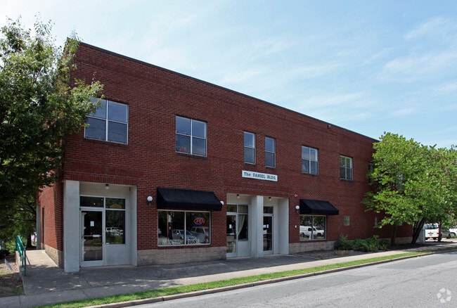
Property Record
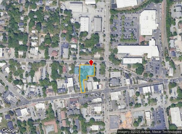
103 W Weaver St, Carrboro, NC 27510

NEARBY LISTINGS FOR SALE OR LEASE
Property Detail
103 W Weaver St
9778862326
Recombination Plat Property Of Gary Buck
Officebuilding
N/S MAIN ST P59/42
X
Orange
3710977800K
North Carolina
2025
0.61 AC
2025
Orange County
010705
Raleigh/Durham
7,540 SF
Durham-Chapel Hill, NC
DEMOGRAPHICS near 103 W Weaver St
1 Mile
3 Mile
5 Mile
2024 Total Population
17,107
61,036
104,258
2029 Population
15,727
56,964
99,207
Pop Growth 2024-2029
(8.07%)
(6.67%)
(4.84%)
Average Age
32
34
38
2024 Total Households
7,134
22,486
40,787
HH Growth 2024-2029
(8.30%)
(7.65%)
(5.03%)
Median Household Inc
$51,719
$68,249
$86,185
Avg Household Size
2.10
2.20
2.30
2024 Avg HH Vehicles
2.00
2.00
2.00
Median Home Value
$401,014
$476,804
$464,804
Median Year Built
1978
1984
1989
Nearby Places
Map Layers
Map Styles
 Street
 Aerial
- Restaurants
- Banks
- Shops
- Fitness
- Groceries
PUBLIC TRANSPORTATION
AIRPORT
Raleigh-Durham International
DRIVE
WALK
Distance
Raleigh-Durham International
32 min
19.7 mi
SALE & LEASE HISTORY
LISTING DATE
SALE/LEASE

Jun 30, 2020
For Lease
Jun 24, 2020
For Lease
Feb 18, 2020
For Lease
Nearby Properties
Address
Land Use
TOTAL SIZE
Lot Size
Zoning
Address
Land Use
TOTAL SIZE
Lot Size
Zoning
215,860 SF
12.28 AC
Address
Land Use
TOTAL SIZE
Lot Size
Zoning
264,710 SF
32.50 AC
R1
Address
Land Use
TOTAL SIZE
Lot Size
Zoning
116,223 SF
34.65 AC
Address
Land Use
TOTAL SIZE
Lot Size
Zoning
244,609 SF
2.72 AC
Address
Land Use
TOTAL SIZE
Lot Size
Zoning
208,406 SF
120.44 AC
R1
Address
Land Use
TOTAL SIZE
Lot Size
Zoning
4,128 SF
678.68 AC
R1
Address
Land Use
TOTAL SIZE
Lot Size
Zoning
81,191 SF
12.33 AC
OI4
Address
Land Use
TOTAL SIZE
Lot Size
Zoning
55,318 SF
9.05 AC
R4
Address
Land Use
TOTAL SIZE
Lot Size
Zoning
238,990 SF
2.43 AC
Address
Land Use
TOTAL SIZE
Lot Size
Zoning
134,448 SF
59.23 AC
Address
Land Use
TOTAL SIZE
Lot Size
Zoning
150,677 SF
2.93 AC
Address
Land Use
TOTAL SIZE
Lot Size
Zoning
119,585 SF
62.30 AC
Address
Land Use
TOTAL SIZE
Lot Size
Zoning
21,078 SF
227.43 AC
OI3R2
Address
Land Use
TOTAL SIZE
Lot Size
Zoning
135,540 SF
4.34 AC
Address
Land Use
TOTAL SIZE
Lot Size
Zoning
26,328 SF
13.86 AC
OR3
Address
Land Use
TOTAL SIZE
Lot Size
Zoning
361,420 SF
1.68 AC
Address
Land Use
TOTAL SIZE
Lot Size
Zoning
85,652 SF
16.49 AC
R1R5
Address
Land Use
TOTAL SIZE
Lot Size
Zoning
17,640 SF
11.51 AC
R4R5C
Address
Land Use
TOTAL SIZE
Lot Size
Zoning
119,517 SF
28.28 AC
R20
Address
Land Use
TOTAL SIZE
Lot Size
Zoning
13,912 SF
18.61 AC
NCR5
Address
Land Use
TOTAL SIZE
Lot Size
Zoning
24,820 SF
1 AC
Address
Land Use
TOTAL SIZE
Lot Size
Zoning
143,750 SF
1.32 AC
OI3OI4
Address
Land Use
TOTAL SIZE
Lot Size
Zoning
174,922 SF
4.59 AC
OI4
Address
Land Use
TOTAL SIZE
Lot Size
Zoning
24,101 SF
13.85 AC
R5
Address
Land Use
TOTAL SIZE
Lot Size
Zoning
15,916 SF
46.02 AC
R10RSIR
Address
Land Use
TOTAL SIZE
Lot Size
Zoning
419,258 SF
39.50 AC
CC
Address
Land Use
TOTAL SIZE
Lot Size
Zoning
12,328 SF
16.37 AC
R75
Address
Land Use
TOTAL SIZE
Lot Size
Zoning
78,028 SF
32.60 AC
Address
Land Use
TOTAL SIZE
Lot Size
Zoning
22,328 SF
19.48 AC
Address
Land Use
TOTAL SIZE
Lot Size
Zoning
82,064 SF
1.41 AC
The World's #1 Commercial Real Estate Marketplace
Connect with us
© 2025 CoStar Group
The information above has been obtained from sources believed reliable. While we do not doubt its accuracy we have not verified it and make no guarantee, warranty or representation about it. It is your responsibility to independently confirm its accuracy and completeness. Any projections, opinions, assumptions, or estimates used are for example only and do not represent the current or future performance of the property. The value of this transaction to you depends on tax and other factors which should be evaluated by your tax, financial, and legal advisors. You and your advisors should conduct a careful, independent investigation of the property to determine to your satisfaction the suitability of the property for your needs.