Property Record
1030 Dry Branch Rd, Hopkins, SC 29061
NEARBY LISTINGS FOR SALE OR LEASE
-
-
View all Hopkins listings for sale on LoopNet.com
Property Detail
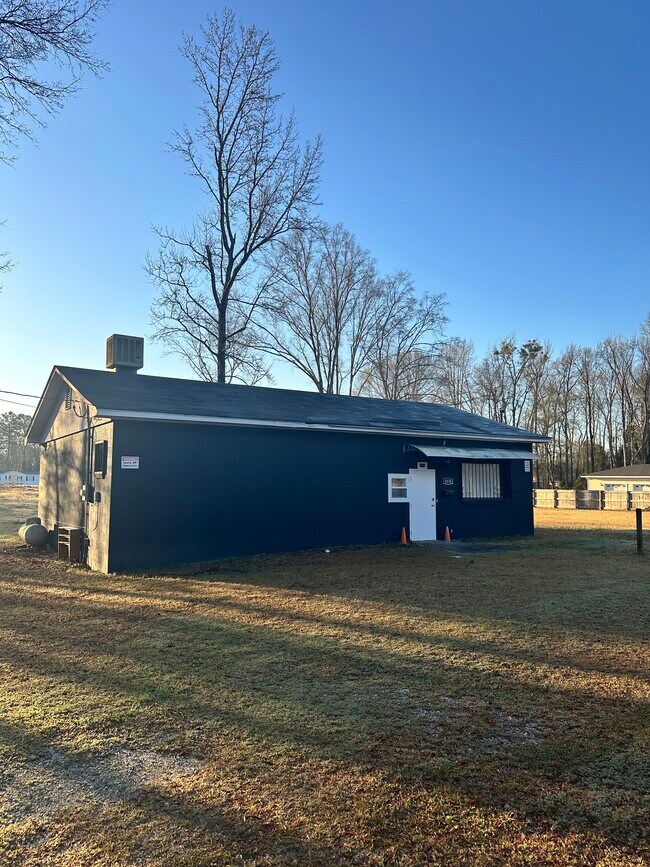
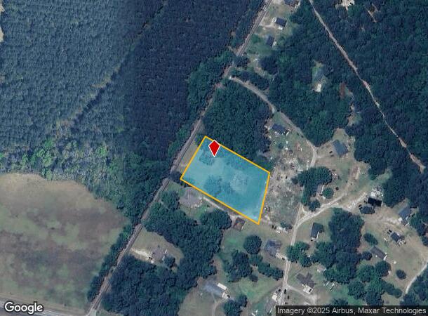
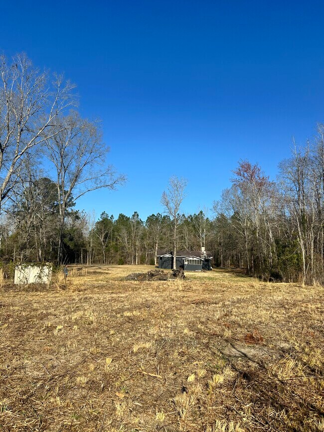
1030 Dry Branch Rd
27300-04-39
The Estate Of Walter Smith And Nancy Smi
Commercialnec
TRACT # 9 230X350.7X241X422.8 #SU #PR X-4538
X
Richland
45079C0535L
South Carolina
2025
2.04 AC
2023
Outlying Richland County
011802
Columbia
1,386 SF
Columbia, SC
DEMOGRAPHICS near 1030 Dry Branch Rd
1 Mile
3 Mile
5 Mile
2024 Total Population
347
2,445
5,427
2029 Population
355
2,533
5,653
Pop Growth 2024-2029
+ 2.31%
+ 3.60%
+ 4.16%
Average Age
43
44
45
2024 Total Households
142
1,016
2,253
HH Growth 2024-2029
+ 2.82%
+ 3.74%
+ 4.31%
Median Household Inc
$31,964
$34,103
$50,262
Avg Household Size
2.50
2.40
2.30
2024 Avg HH Vehicles
2.00
2.00
2.00
Median Home Value
$207,317
$95,537
$92,509
Median Year Built
1982
1990
1989
Nearby Places
Map Layers
Map Styles
 Street
 Aerial
- Restaurants
- Banks
- Shops
- Fitness
- Groceries
PUBLIC TRANSPORTATION
AIRPORT
Columbia Metro
DRIVE
WALK
Distance
Columbia Metro
42 min
25.1 mi
Freight Ports
North Charleston Terminal
DRIVE
WALK
Distance
North Charleston Terminal
131 min
102.5 mi
SALE & LEASE HISTORY
LISTING DATE
SALE/LEASE

Mar 12, 2025
For Sale
Nearby Properties
Address
Land Use
TOTAL SIZE
Lot Size
Zoning
Address
Land Use
TOTAL SIZE
Lot Size
Zoning
8,972 SF
3.24 AC
RU
Address
Land Use
TOTAL SIZE
Lot Size
Zoning
7,882 SF
3.91 AC
RU
Address
Land Use
TOTAL SIZE
Lot Size
Zoning
11,080 SF
43 AC
RU
Address
Land Use
TOTAL SIZE
Lot Size
Zoning
8,165 SF
1.39 AC
RC
Address
Land Use
TOTAL SIZE
Lot Size
Zoning
261.77 AC
RU
Address
Land Use
TOTAL SIZE
Lot Size
Zoning
6,607 SF
4 AC
RU
Address
Land Use
TOTAL SIZE
Lot Size
Zoning
6,402 SF
7.14 AC
RU
Address
Land Use
TOTAL SIZE
Lot Size
Zoning
4,326 SF
2 AC
RU
Address
Land Use
TOTAL SIZE
Lot Size
Zoning
3,432 SF
8.17 AC
RU
Address
Land Use
TOTAL SIZE
Lot Size
Zoning
4,335 SF
1.12 AC
RU
Address
Land Use
TOTAL SIZE
Lot Size
Zoning
3,410 SF
5.70 AC
RU
Address
Land Use
TOTAL SIZE
Lot Size
Zoning
2,356 SF
0.97 AC
RU
Address
Land Use
TOTAL SIZE
Lot Size
Zoning
2,128 SF
1.68 AC
RU
Address
Land Use
TOTAL SIZE
Lot Size
Zoning
1,524 SF
1.51 AC
RU
Address
Land Use
TOTAL SIZE
Lot Size
Zoning
2,958 SF
1.51 AC
RU
Address
Land Use
TOTAL SIZE
Lot Size
Zoning
1,149 SF
1.53 AC
RU
Address
Land Use
TOTAL SIZE
Lot Size
Zoning
1,800 SF
0.97 AC
RU
Address
Land Use
TOTAL SIZE
Lot Size
Zoning
4,176 SF
0.97 AC
RU
Address
Land Use
TOTAL SIZE
Lot Size
Zoning
1,352 SF
0.81 AC
RU
Address
Land Use
TOTAL SIZE
Lot Size
Zoning
777 SF
24.59 AC
RU
Address
Land Use
TOTAL SIZE
Lot Size
Zoning
2,685 SF
0.99 AC
RU
Address
Land Use
TOTAL SIZE
Lot Size
Zoning
2,472 SF
22.12 AC
RU
Address
Land Use
TOTAL SIZE
Lot Size
Zoning
1,636 SF
2.17 AC
RU
Address
Land Use
TOTAL SIZE
Lot Size
Zoning
2,052 SF
1.58 AC
RU
Address
Land Use
TOTAL SIZE
Lot Size
Zoning
17.53 AC
RU
Address
Land Use
TOTAL SIZE
Lot Size
Zoning
377.96 AC
RU
Address
Land Use
TOTAL SIZE
Lot Size
Zoning
364.40 AC
RU
Address
Land Use
TOTAL SIZE
Lot Size
Zoning
1,960 SF
7.08 AC
RU
Address
Land Use
TOTAL SIZE
Lot Size
Zoning
1,500 SF
2 AC
RU
Address
Land Use
TOTAL SIZE
Lot Size
Zoning
2,544 SF
2.60 AC
RU
The World's #1 Commercial Real Estate Marketplace
Connect with us
© 2026 CoStar Group
The information above has been obtained from sources believed reliable. While we do not doubt its accuracy we have not verified it and make no guarantee, warranty or representation about it. It is your responsibility to independently confirm its accuracy and completeness. Any projections, opinions, assumptions, or estimates used are for example only and do not represent the current or future performance of the property. The value of this transaction to you depends on tax and other factors which should be evaluated by your tax, financial, and legal advisors. You and your advisors should conduct a careful, independent investigation of the property to determine to your satisfaction the suitability of the property for your needs.