Property Record
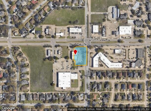
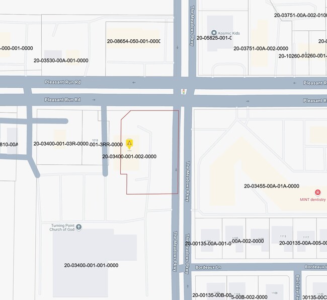
1030 E Pleasant Run Rd, Desoto, TX 75115

NEARBY LISTINGS FOR SALE OR LEASE
Property Detail
1030 E Pleasant Run Rd
Dallas-Fort Worth-Arlington, TX
Food Lion
20034000010020000
FOOD LION BLK 1 LT 2 ACS 0.931 INT202500074253 DD04102025 CO-DC 0340000100200 5CS03400001
Storebuilding
Dallas
X
Texas
48139C0055G
2
2024
0.93 AC
2025
C Hill/Dunc'vlle/Deso
016620
Dallas/Ft Worth
9,710 SF
DEMOGRAPHICS near 1030 E Pleasant Run Rd
1 Mile
3 Mile
5 Mile
2024 Total Population
9,913
65,769
172,064
2029 Population
9,701
64,912
173,345
Pop Growth 2024-2029
(2.14%)
(1.30%)
+ 0.74%
Average Age
40
38
37
2024 Total Households
3,752
22,786
59,249
HH Growth 2024-2029
(2.37%)
(1.58%)
+ 0.46%
Median Household Inc
$72,430
$69,438
$62,074
Avg Household Size
2.60
2.80
2.80
2024 Avg HH Vehicles
2.00
2.00
2.00
Median Home Value
$219,432
$214,396
$217,007
Median Year Built
1985
1991
1989
Nearby Places
Map Layers
Map Styles
 Street
 Aerial
- Restaurants
- Banks
- Shops
- Fitness
- Groceries
PUBLIC TRANSPORTATION
AIRPORT
Dallas Love Field
DRIVE
WALK
Distance
Dallas Love Field
30 min
19.2 mi
Dallas-Fort Worth International
DRIVE
WALK
Distance
Dallas-Fort Worth International
42 min
32.0 mi
Nearby Properties
Address
Land Use
TOTAL SIZE
Lot Size
Zoning
Address
Land Use
TOTAL SIZE
Lot Size
Zoning
1,283,264 SF
78.52 AC
Z04
Address
Land Use
TOTAL SIZE
Lot Size
Zoning
1,316,325 SF
54.36 AC
Z111
Address
Land Use
TOTAL SIZE
Lot Size
Zoning
1,167,500 SF
46.04 AC
Z06
Address
Land Use
TOTAL SIZE
Lot Size
Zoning
951,480 SF
50.63 AC
Z109
Address
Land Use
TOTAL SIZE
Lot Size
Zoning
948,392 SF
50.80 AC
Z109
Address
Land Use
TOTAL SIZE
Lot Size
Zoning
900,000 SF
50.76 AC
Z04
Address
Land Use
TOTAL SIZE
Lot Size
Zoning
872,640 SF
46.97 AC
Z125
Address
Land Use
TOTAL SIZE
Lot Size
Zoning
823,000 SF
45.10 AC
Z298
Address
Land Use
TOTAL SIZE
Lot Size
Zoning
660,400 SF
35.93 AC
Z125
Address
Land Use
TOTAL SIZE
Lot Size
Zoning
595,148 SF
34.96 AC
Z39
Address
Land Use
TOTAL SIZE
Lot Size
Zoning
123,880 SF
16.80 AC
Z236
Address
Land Use
TOTAL SIZE
Lot Size
Zoning
610,806 SF
33.66 AC
Z125
Address
Land Use
TOTAL SIZE
Lot Size
Zoning
610,806 SF
34.20 AC
Z125
Address
Land Use
TOTAL SIZE
Lot Size
Zoning
590,200 SF
31.83 AC
Z04
Address
Land Use
TOTAL SIZE
Lot Size
Zoning
507,318 SF
28.40 AC
Z111
Address
Land Use
TOTAL SIZE
Lot Size
Zoning
552,200 SF
41.36 AC
Z109
Address
Land Use
TOTAL SIZE
Lot Size
Zoning
610,669 SF
41.65 AC
Z125
Address
Land Use
TOTAL SIZE
Lot Size
Zoning
489,310 SF
33.91 AC
Z111
Address
Land Use
TOTAL SIZE
Lot Size
Zoning
531,254 SF
33.40 AC
Z06
Address
Land Use
TOTAL SIZE
Lot Size
Zoning
227,423 SF
13.86 AC
Z236
Address
Land Use
TOTAL SIZE
Lot Size
Zoning
469,000 SF
28.81 AC
Z125
Address
Land Use
TOTAL SIZE
Lot Size
Zoning
281,669 SF
16.02 AC
Z312
Address
Land Use
TOTAL SIZE
Lot Size
Zoning
453,600 SF
29.54 AC
Z236
Address
Land Use
TOTAL SIZE
Lot Size
Zoning
419,328 SF
23.30 AC
Z04
Address
Land Use
TOTAL SIZE
Lot Size
Zoning
421,890 SF
23.95 AC
Z111
Address
Land Use
TOTAL SIZE
Lot Size
Zoning
406,400 SF
22.15 AC
Z125
Address
Land Use
TOTAL SIZE
Lot Size
Zoning
400,000 SF
24.69 AC
Z116
Address
Land Use
TOTAL SIZE
Lot Size
Zoning
444,216 SF
23.99 AC
Z39
Address
Land Use
TOTAL SIZE
Lot Size
Zoning
656,500 SF
33.34 AC
Z04
Address
Land Use
TOTAL SIZE
Lot Size
Zoning
253,794 SF
10.23 AC
Z201
The World's #1 Commercial Real Estate Marketplace
Connect with us
© 2026 CoStar Group
The information above has been obtained from sources believed reliable. While we do not doubt its accuracy we have not verified it and make no guarantee, warranty or representation about it. It is your responsibility to independently confirm its accuracy and completeness. Any projections, opinions, assumptions, or estimates used are for example only and do not represent the current or future performance of the property. The value of this transaction to you depends on tax and other factors which should be evaluated by your tax, financial, and legal advisors. You and your advisors should conduct a careful, independent investigation of the property to determine to your satisfaction the suitability of the property for your needs.