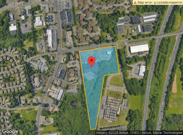
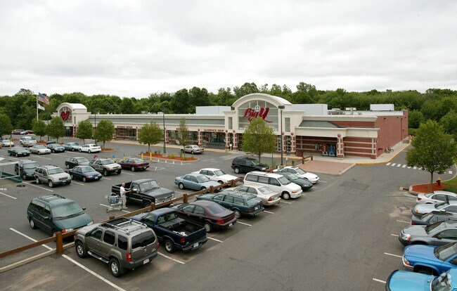
Property Record
1030 Elm St, Rocky Hill, CT 06067

NEARBY LISTINGS FOR SALE OR LEASE
Property Detail
1030 Elm St
ROCK-000012-000000-000169
Hartford
Commercialnec
Connecticut
X
169
09003C0516F
14.11 AC
2025
Rocky Hill
2025
Hartford
524200
Hartford-West Hartford-East Hartford, CT
DEMOGRAPHICS near 1030 Elm St
1 Mile
3 Mile
5 Mile
2024 Total Population
5,206
49,124
124,782
2029 Population
5,186
49,022
123,812
Pop Growth 2024-2029
(0.38%)
(0.21%)
(0.78%)
Average Age
45
43
42
2024 Total Households
2,064
20,559
52,175
HH Growth 2024-2029
(0.48%)
(0.19%)
(0.78%)
Median Household Inc
$97,803
$98,072
$90,369
Avg Household Size
2.40
2.30
2.30
2024 Avg HH Vehicles
2.00
2.00
2.00
Median Home Value
$323,426
$293,014
$270,376
Median Year Built
1982
1974
1969
Nearby Places
Map Layers
Map Styles
 Street
 Aerial
- Restaurants
- Banks
- Shops
- Fitness
- Groceries
PUBLIC TRANSPORTATION
COMMUTER RAIL
DRIVE
WALK
Distance
13 min
6.3 mi
DRIVE
WALK
Distance
13 min
6.3 mi
AIRPORT
Bradley International
DRIVE
WALK
Distance
Bradley International
39 min
25.2 mi
Tweed/New Haven
DRIVE
WALK
Distance
Tweed/New Haven
48 min
32.7 mi
Freight Ports
Port of New Haven
DRIVE
WALK
Distance
Port of New Haven
43 min
31.5 mi
SALE & LEASE HISTORY
LISTING DATE
SALE/LEASE

Jun 16, 2025
For Sale
Nearby Properties
Address
Land Use
TOTAL SIZE
Lot Size
Zoning
Address
Land Use
TOTAL SIZE
Lot Size
Zoning
109,079 SF
110.62 AC
OT
Address
Land Use
TOTAL SIZE
Lot Size
Zoning
24.70 AC
R-20
Address
Land Use
TOTAL SIZE
Lot Size
Zoning
81,507 SF
21.60 AC
R-20
Address
Land Use
TOTAL SIZE
Lot Size
Zoning
54.95 AC
PDR
Address
Land Use
TOTAL SIZE
Lot Size
Zoning
117,178 SF
13.02 AC
R-20
Address
Land Use
TOTAL SIZE
Lot Size
Zoning
33.30 AC
R-20
Address
Land Use
TOTAL SIZE
Lot Size
Zoning
43.15 AC
R-20
Address
Land Use
TOTAL SIZE
Lot Size
Zoning
248,626 SF
92.26 AC
BP-2
Address
Land Use
TOTAL SIZE
Lot Size
Zoning
403,000 SF
33.55 AC
IND
Address
Land Use
TOTAL SIZE
Lot Size
Zoning
23.08 AC
BP-2
Address
Land Use
TOTAL SIZE
Lot Size
Zoning
87,037 SF
10.44 AC
R-20
Address
Land Use
TOTAL SIZE
Lot Size
Zoning
Address
Land Use
TOTAL SIZE
Lot Size
Zoning
310,582 SF
32.72 AC
OP
Address
Land Use
TOTAL SIZE
Lot Size
Zoning
9.81 AC
OP
Address
Land Use
TOTAL SIZE
Lot Size
Zoning
1.99 AC
C
Address
Land Use
TOTAL SIZE
Lot Size
Zoning
21.35 AC
PD
Address
Land Use
TOTAL SIZE
Lot Size
Zoning
9.09 AC
R-20
Address
Land Use
TOTAL SIZE
Lot Size
Zoning
188,427 SF
8.55 AC
SRD
Address
Land Use
TOTAL SIZE
Lot Size
Zoning
18.40 AC
PD
Address
Land Use
TOTAL SIZE
Lot Size
Zoning
38,860 SF
38.47 AC
PS-B
Address
Land Use
TOTAL SIZE
Lot Size
Zoning
10.45 AC
R-20
Address
Land Use
TOTAL SIZE
Lot Size
Zoning
83,468 SF
6.65 AC
R-20
Address
Land Use
TOTAL SIZE
Lot Size
Zoning
Address
Land Use
TOTAL SIZE
Lot Size
Zoning
145,956 SF
11.27 AC
OP
Address
Land Use
TOTAL SIZE
Lot Size
Zoning
13.85 AC
R-20
Address
Land Use
TOTAL SIZE
Lot Size
Zoning
16.29 AC
PD
Address
Land Use
TOTAL SIZE
Lot Size
Zoning
49,724 SF
9.02 AC
OP
Address
Land Use
TOTAL SIZE
Lot Size
Zoning
13.61 AC
RC
Address
Land Use
TOTAL SIZE
Lot Size
Zoning
8.56 AC
TC
Address
Land Use
TOTAL SIZE
Lot Size
Zoning
172,155 SF
57.35 AC
OP
The World's #1 Commercial Real Estate Marketplace
Connect with us
© 2026 CoStar Group
The information above has been obtained from sources believed reliable. While we do not doubt its accuracy we have not verified it and make no guarantee, warranty or representation about it. It is your responsibility to independently confirm its accuracy and completeness. Any projections, opinions, assumptions, or estimates used are for example only and do not represent the current or future performance of the property. The value of this transaction to you depends on tax and other factors which should be evaluated by your tax, financial, and legal advisors. You and your advisors should conduct a careful, independent investigation of the property to determine to your satisfaction the suitability of the property for your needs.