Property Record
1030 Frank Rd, Columbus, OH 43223
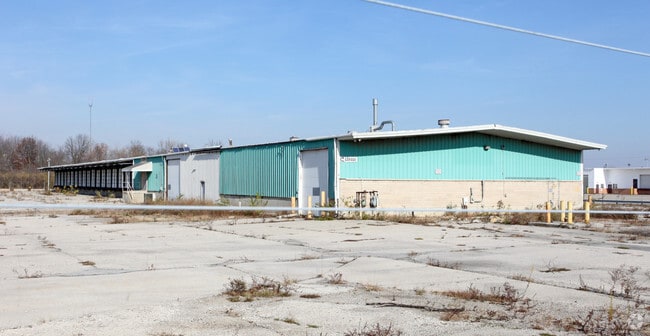
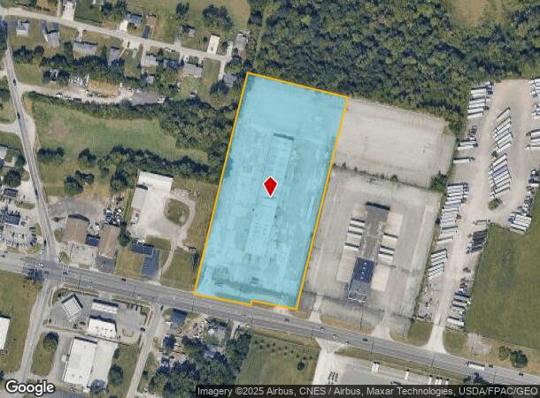
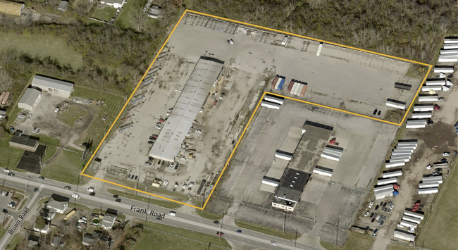
This Property Is For Sale
NEARBY LISTINGS FOR SALE OR LEASE
Property Detail
1030 Frank Rd
140-003394
Virginia Military Survey #420
Truckterminal
1028-032 FRANK RD 6.033 ACRES ENTRY 420
X
Franklin
39049C0316K
Ohio
2024
6.03 AC
2024
SW Columbus
008330
Columbus
19,768 SF
Columbus, OH
DEMOGRAPHICS near 1030 Frank Rd
1 Mile
3 Mile
5 Mile
2024 Total Population
6,542
82,193
259,568
2029 Population
6,539
82,780
262,431
Pop Growth 2024-2029
(0.05%)
+ 0.71%
+ 1.10%
Average Age
38
38
38
2024 Total Households
2,041
32,045
110,402
HH Growth 2024-2029
(0.05%)
+ 0.65%
+ 1.12%
Median Household Inc
$75,268
$56,783
$61,529
Avg Household Size
2.70
2.40
2.20
2024 Avg HH Vehicles
2.00
2.00
2.00
Median Home Value
$164,413
$161,118
$205,217
Median Year Built
1988
1962
1966
Nearby Places
- Restaurants
- Banks
- Shops
- Fitness
- Groceries
PUBLIC TRANSPORTATION
AIRPORT
John Glenn Columbus International
DRIVE
WALK
Distance
John Glenn Columbus International
20 min
12.5 mi
Rickenbacker International
DRIVE
WALK
Distance
Rickenbacker International
20 min
12.9 mi
Freight Ports
Port of Toledo
DRIVE
WALK
Distance
Port of Toledo
189 min
148.6 mi
Nearby Properties
Address
Land Use
TOTAL SIZE
Lot Size
Zoning
Address
Land Use
TOTAL SIZE
Lot Size
Zoning
382.42 AC
Address
Land Use
TOTAL SIZE
Lot Size
Zoning
838,846 SF
3.73 AC
Address
Land Use
TOTAL SIZE
Lot Size
Zoning
1,058 SF
0.03 AC
Address
Land Use
TOTAL SIZE
Lot Size
Zoning
859,800 SF
68.91 AC
Address
Land Use
TOTAL SIZE
Lot Size
Zoning
496,729 SF
3.47 AC
Address
Land Use
TOTAL SIZE
Lot Size
Zoning
125,467 SF
20.61 AC
Address
Land Use
TOTAL SIZE
Lot Size
Zoning
928,228 SF
39.80 AC
Address
Land Use
TOTAL SIZE
Lot Size
Zoning
523,793 SF
6.94 AC
Address
Land Use
TOTAL SIZE
Lot Size
Zoning
128,263 SF
6.59 AC
Address
Land Use
TOTAL SIZE
Lot Size
Zoning
169,252 SF
22.06 AC
Address
Land Use
TOTAL SIZE
Lot Size
Zoning
490,170 SF
2.91 AC
Address
Land Use
TOTAL SIZE
Lot Size
Zoning
455,534 SF
3.01 AC
Address
Land Use
TOTAL SIZE
Lot Size
Zoning
493,000 SF
29.55 AC
Address
Land Use
TOTAL SIZE
Lot Size
Zoning
163,629 SF
26.71 AC
Address
Land Use
TOTAL SIZE
Lot Size
Zoning
229,640 SF
2.88 AC
Address
Land Use
TOTAL SIZE
Lot Size
Zoning
24,592 SF
76.12 AC
Address
Land Use
TOTAL SIZE
Lot Size
Zoning
322,000 SF
22.14 AC
Address
Land Use
TOTAL SIZE
Lot Size
Zoning
361,060 SF
1.49 AC
Address
Land Use
TOTAL SIZE
Lot Size
Zoning
408,294 SF
26.64 AC
Address
Land Use
TOTAL SIZE
Lot Size
Zoning
322,000 SF
18.83 AC
Address
Land Use
TOTAL SIZE
Lot Size
Zoning
404,812 SF
41.33 AC
Address
Land Use
TOTAL SIZE
Lot Size
Zoning
399,784 SF
20.86 AC
Address
Land Use
TOTAL SIZE
Lot Size
Zoning
137,488 SF
13.44 AC
Address
Land Use
TOTAL SIZE
Lot Size
Zoning
150,289 SF
25.19 AC
Address
Land Use
TOTAL SIZE
Lot Size
Zoning
156,638 SF
1.95 AC
Address
Land Use
TOTAL SIZE
Lot Size
Zoning
132,379 SF
15.46 AC
Address
Land Use
TOTAL SIZE
Lot Size
Zoning
61,595 SF
9.75 AC
Address
Land Use
TOTAL SIZE
Lot Size
Zoning
146,172 SF
26.42 AC
Address
Land Use
TOTAL SIZE
Lot Size
Zoning
221,616 SF
10.62 AC
Address
Land Use
TOTAL SIZE
Lot Size
Zoning
75,164 SF
16.26 AC
The World's #1 Commercial Real Estate Marketplace
Connect with us
© 2025 CoStar Group
The information above has been obtained from sources believed reliable. While we do not doubt its accuracy we have not verified it and make no guarantee, warranty or representation about it. It is your responsibility to independently confirm its accuracy and completeness. Any projections, opinions, assumptions, or estimates used are for example only and do not represent the current or future performance of the property. The value of this transaction to you depends on tax and other factors which should be evaluated by your tax, financial, and legal advisors. You and your advisors should conduct a careful, independent investigation of the property to determine to your satisfaction the suitability of the property for your needs.