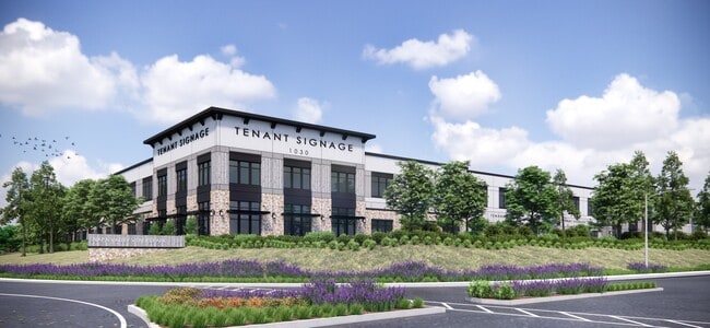
Property Record
1030 Kaiser Rd, Napa, CA 94558


Current Lease Availabilities
NEARBY LISTINGS FOR SALE OR LEASE
Property Detail
1030 Kaiser Rd
Napa, CA
Napa Valley
046-370-004
PCL 1 MAP NO 2305 18R/S22
Industrialacreage
Napa
X
California
06055C0519G
10.21 AC
2024
Napa County
2025
North Bay/Santa Rosa
200900
DEMOGRAPHICS near 1030 Kaiser Rd
1 Mile
3 Mile
5 Mile
2024 Total Population
27
27,989
68,478
2029 Population
27
27,656
66,925
Pop Growth 2024-2029
0.00%
(1.19%)
(2.27%)
Average Age
41
40
42
2024 Total Households
10
10,158
25,172
HH Growth 2024-2029
0.00%
(1.15%)
(2.42%)
Median Household Inc
$5,000
$91,042
$95,717
Avg Household Size
2.00
2.60
2.60
2024 Avg HH Vehicles
.00
2.00
2.00
Median Home Value
$750,000
$805,162
$797,373
Median Year Built
1992
1973
1972
Nearby Places
Map Layers
Map Styles
 Street
 Aerial
- Restaurants
- Banks
- Shops
- Fitness
- Groceries
PUBLIC TRANSPORTATION
AIRPORT
Charles M Schulz - Sonoma County
DRIVE
WALK
Distance
Charles M Schulz - Sonoma County
67 min
48.5 mi
Freight Ports
Port of Richmond
DRIVE
WALK
Distance
Port of Richmond
48 min
34.2 mi
Nearby Properties
Address
Land Use
TOTAL SIZE
Lot Size
Zoning
Address
Land Use
TOTAL SIZE
Lot Size
Zoning
38.18 AC
Address
Land Use
TOTAL SIZE
Lot Size
Zoning
219,739 SF
8.40 AC
AWAC
Address
Land Use
TOTAL SIZE
Lot Size
Zoning
259,544 SF
20.63 AC
AWAC
Address
Land Use
TOTAL SIZE
Lot Size
Zoning
160,241 SF
12.54 AC
Address
Land Use
TOTAL SIZE
Lot Size
Zoning
19.27 AC
Address
Land Use
TOTAL SIZE
Lot Size
Zoning
149,714 SF
0.40 AC
Address
Land Use
TOTAL SIZE
Lot Size
Zoning
9.32 AC
IPA
Address
Land Use
TOTAL SIZE
Lot Size
Zoning
283,311 SF
8.27 AC
Address
Land Use
TOTAL SIZE
Lot Size
Zoning
97,515 SF
0.30 AC
03
Address
Land Use
TOTAL SIZE
Lot Size
Zoning
139,409 SF
6.54 AC
IPA
Address
Land Use
TOTAL SIZE
Lot Size
Zoning
2.95 AC
Address
Land Use
TOTAL SIZE
Lot Size
Zoning
149,600 SF
7.08 AC
Address
Land Use
TOTAL SIZE
Lot Size
Zoning
158,793 SF
16.04 AC
Address
Land Use
TOTAL SIZE
Lot Size
Zoning
250,652 SF
16.18 AC
Address
Land Use
TOTAL SIZE
Lot Size
Zoning
80,498 SF
2.38 AC
Address
Land Use
TOTAL SIZE
Lot Size
Zoning
1,080 SF
13.79 AC
AW
Address
Land Use
TOTAL SIZE
Lot Size
Zoning
53,871 SF
2.49 AC
CT
Address
Land Use
TOTAL SIZE
Lot Size
Zoning
105,371 SF
0.83 AC
CD
Address
Land Use
TOTAL SIZE
Lot Size
Zoning
226,044 SF
6.22 AC
Address
Land Use
TOTAL SIZE
Lot Size
Zoning
150,904 SF
9.96 AC
IPAC
Address
Land Use
TOTAL SIZE
Lot Size
Zoning
157,093 SF
12.58 AC
CC
Address
Land Use
TOTAL SIZE
Lot Size
Zoning
134,629 SF
4.13 AC
Address
Land Use
TOTAL SIZE
Lot Size
Zoning
77,404 SF
10.09 AC
IPAC
Address
Land Use
TOTAL SIZE
Lot Size
Zoning
30,449 SF
1.23 AC
Address
Land Use
TOTAL SIZE
Lot Size
Zoning
27,442 SF
16.58 AC
IPB
Address
Land Use
TOTAL SIZE
Lot Size
Zoning
68,360 SF
1.58 AC
CDP
Address
Land Use
TOTAL SIZE
Lot Size
Zoning
68,409 SF
5.66 AC
RM
Address
Land Use
TOTAL SIZE
Lot Size
Zoning
34,214 SF
9.17 AC
IPAC
Address
Land Use
TOTAL SIZE
Lot Size
Zoning
107,111 SF
6.20 AC
The World's #1 Commercial Real Estate Marketplace
Connect with us
© 2025 CoStar Group
The information above has been obtained from sources believed reliable. While we do not doubt its accuracy we have not verified it and make no guarantee, warranty or representation about it. It is your responsibility to independently confirm its accuracy and completeness. Any projections, opinions, assumptions, or estimates used are for example only and do not represent the current or future performance of the property. The value of this transaction to you depends on tax and other factors which should be evaluated by your tax, financial, and legal advisors. You and your advisors should conduct a careful, independent investigation of the property to determine to your satisfaction the suitability of the property for your needs.