Property Record
1030 Putnam Ave, Marstons Mills, MA 02648


Save to a Folder
{{folder.Name}}
{{folder.ListingIds.length}} Properties
{{folder.ListingIds.length}} Property
Create a New Folder
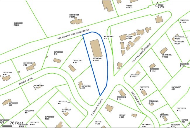
Property Detail
1030 Putnam Ave
Storebuilding
Barnstable
VB-A;R
Massachusetts
B and X Area of moderate flood hazard, usually the area between the limits of the 100-year and 500-year floods.
3001
2025
1.37 AC
2025
Other Market Areas
013200
Barnstable Town, MA
8,775 SF
MMIL-000057-000000-000003-000001
NEARBY LISTINGS FOR SALE OR LEASE
DEMOGRAPHICS near 1030 Putnam Ave
1 mile
3 mile
5 mile
2025 Total Population
1,778
20,319
42,074
2030 Population
1,736
19,949
41,201
Pop Growth 2025-2030
(2.36%)
(1.82%)
(2.07%)
Average Age
50
48
48
2025 Total Households
732
8,454
17,687
HH Growth 2025-2030
(2.46%)
(1.85%)
(2.11%)
Median Household Inc
$131,743
$109,237
$109,459
Avg Household Size
2.40
2.30
2.30
2025 Avg HH Vehicles
2.00
2.00
2.00
Median Home Value
$778,846
$690,811
$668,888
Median Year Built
1984
1983
1983
Nearby Places
Map Layers
Map Styles
 Street
 Aerial
Layers
 Traffic
 Biking
Places
Listings with unknown addresses are not visible on the map
- Restaurants
- Banks
- Shops
- Fitness
- Groceries
PUBLIC TRANSPORTATION
COMMUTER RAIL
Drive
Walk
Distance
15 min
8.0 mi
AIRPORT
Martha's Vineyard
Drive
Walk
Distance
Martha's Vineyard
92 min
31.5 mi
Freight Ports
Port of New Bedford Harbor
Drive
Walk
Distance
Port of New Bedford Harbor
65 min
45.2 mi
Nearby Properties
Address
Land Use
TOTAL SIZE
Lot Size
Zoning
Address
Land Use
TOTAL SIZE
Lot Size
Zoning
Address
Land Use
TOTAL SIZE
Lot Size
Zoning
3.28 AC
RF
Address
Land Use
TOTAL SIZE
Lot Size
Zoning
79,282 SF
43.70 AC
RC;BA
Address
Land Use
TOTAL SIZE
Lot Size
Zoning
6.44 AC
RF
Address
Land Use
TOTAL SIZE
Lot Size
Zoning
6,460 SF
9 AC
RF
Address
Land Use
TOTAL SIZE
Lot Size
Zoning
4.66 AC
R
Address
Land Use
TOTAL SIZE
Lot Size
Zoning
13.30 AC
I1
Address
Land Use
TOTAL SIZE
Lot Size
Zoning
2.72 AC
1
Address
Land Use
TOTAL SIZE
Lot Size
Zoning
6,095 SF
2.26 AC
1
Address
Land Use
TOTAL SIZE
Lot Size
Zoning
5.46 AC
RF
Address
Land Use
TOTAL SIZE
Lot Size
Zoning
Address
Land Use
TOTAL SIZE
Lot Size
Zoning
9,162 SF
3.11 AC
RF
Address
Land Use
TOTAL SIZE
Lot Size
Zoning
1.34 AC
RF
Address
Land Use
TOTAL SIZE
Lot Size
Zoning
3.92 AC
R
Address
Land Use
TOTAL SIZE
Lot Size
Zoning
7,528 SF
2.20 AC
RF
Address
Land Use
TOTAL SIZE
Lot Size
Zoning
2.32 AC
RF
Address
Land Use
TOTAL SIZE
Lot Size
Zoning
1.52 AC
RF;RF-
Address
Land Use
TOTAL SIZE
Lot Size
Zoning
0.28 AC
RF
Address
Land Use
TOTAL SIZE
Lot Size
Zoning
7.55 AC
VB-A;S
Address
Land Use
TOTAL SIZE
Lot Size
Zoning
69,251 SF
7.06 AC
S&D;RF
Address
Land Use
TOTAL SIZE
Lot Size
Zoning
3.11 AC
RF
Address
Land Use
TOTAL SIZE
Lot Size
Zoning
1.52 AC
RF
Address
Land Use
TOTAL SIZE
Lot Size
Zoning
6,226 SF
2.85 AC
Address
Land Use
TOTAL SIZE
Lot Size
Zoning
158.42 AC
R
Address
Land Use
TOTAL SIZE
Lot Size
Zoning
2.45 AC
RC;RF-
Address
Land Use
TOTAL SIZE
Lot Size
Zoning
1.97 AC
RF
Address
Land Use
TOTAL SIZE
Lot Size
Zoning
2.82 AC
RF
Address
Land Use
TOTAL SIZE
Lot Size
Zoning
5.20 AC
RF
Address
Land Use
TOTAL SIZE
Lot Size
Zoning
2.91 AC
RF
Address
Land Use
TOTAL SIZE
Lot Size
Zoning
7.43 AC
RF
The World's #1 Commercial Real Estate Marketplace
Connect with us
© 2026 CoStar Group
The information above has been obtained from sources believed reliable. While we do not doubt its accuracy we have not verified it and make no guarantee, warranty or representation about it. It is your responsibility to independently confirm its accuracy and completeness. Any projections, opinions, assumptions, or estimates used are for example only and do not represent the current or future performance of the property. The value of this transaction to you depends on tax and other factors which should be evaluated by your tax, financial, and legal advisors. You and your advisors should conduct a careful, independent investigation of the property to determine to your satisfaction the suitability of the property for your needs.