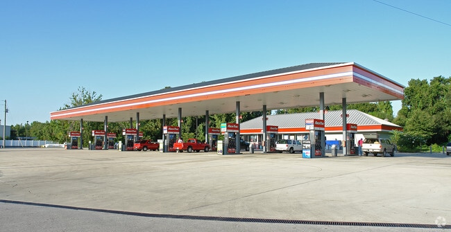
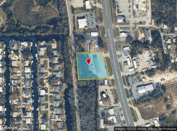
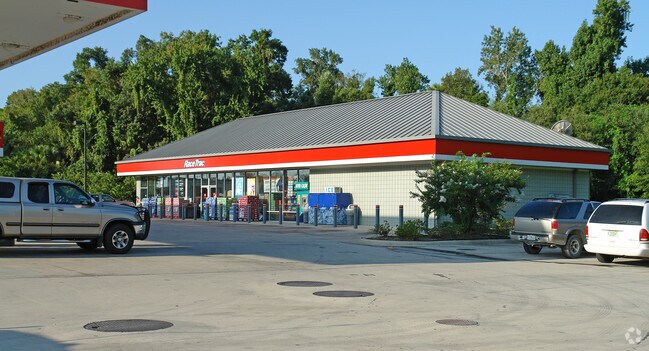
Property Record
1030 Se Us Highway 19, Crystal River, FL 34429
NEARBY LISTINGS FOR SALE OR LEASE
Property Detail
1030 Se Us Highway 19
17E-18S-28-0000-12110
Unrec Tracts In 28-18S-17E
Storemultistory
COM AT SE COR OF NE 1/4 OF NE3 1/4 OF SEC 28-18-17 TH S 00DEG 10M 10S W AL SD SEC LN 164.49 FT TO AN IRON PIN SET ON WLY R/W LN OF US HWY 19 SD PT BEING THE TRUE POB FROM THE TRUE POB RUN TH AL WLY R/W LN OF US HWY 19 AL A CURVE TO LEFT HAVING A RADI
AE
Citrus
12017C0189E
Florida
2024
2.43 AC
2025
Florida Central North Area
450501
Other Market Areas
3,952 SF
Homosassa Springs, FL
DEMOGRAPHICS near 1030 Se Us Highway 19
1 Mile
3 Mile
5 Mile
2024 Total Population
2,869
13,015
23,789
2029 Population
3,329
14,892
27,058
Pop Growth 2024-2029
+ 16.03%
+ 14.42%
+ 13.74%
Average Age
57
51
51
2024 Total Households
1,328
6,087
10,895
HH Growth 2024-2029
+ 16.11%
+ 14.28%
+ 13.54%
Median Household Inc
$46,449
$47,555
$48,902
Avg Household Size
2.00
2.10
2.10
2024 Avg HH Vehicles
2.00
2.00
2.00
Median Home Value
$257,894
$209,722
$217,539
Median Year Built
1988
1984
1986
Nearby Places
Map Layers
Map Styles
 Street
 Aerial
- Restaurants
- Banks
- Shops
- Fitness
- Groceries
Nearby Properties
Address
Land Use
TOTAL SIZE
Lot Size
Zoning
Address
Land Use
TOTAL SIZE
Lot Size
Zoning
565,081 SF
188.72 AC
PI
Address
Land Use
TOTAL SIZE
Lot Size
Zoning
220,962 SF
21.29 AC
PI
Address
Land Use
TOTAL SIZE
Lot Size
Zoning
258,908 SF
14.52 AC
CH
Address
Land Use
TOTAL SIZE
Lot Size
Zoning
5,865 SF
82.73 AC
MHP
Address
Land Use
TOTAL SIZE
Lot Size
Zoning
129,200 SF
22.19 AC
CH
Address
Land Use
TOTAL SIZE
Lot Size
Zoning
514,563 SF
22.95 AC
CH
Address
Land Use
TOTAL SIZE
Lot Size
Zoning
10,928 SF
97.17 AC
PUD
Address
Land Use
TOTAL SIZE
Lot Size
Zoning
104,427 SF
11.98 AC
MDR
Address
Land Use
TOTAL SIZE
Lot Size
Zoning
209,094 SF
15.63 AC
GNC
Address
Land Use
TOTAL SIZE
Lot Size
Zoning
73,297 SF
163.02 AC
TCU
Address
Land Use
TOTAL SIZE
Lot Size
Zoning
57.60 AC
R2
Address
Land Use
TOTAL SIZE
Lot Size
Zoning
249,536 SF
10.80 AC
GNC
Address
Land Use
TOTAL SIZE
Lot Size
Zoning
100,608 SF
21.34 AC
TCU
Address
Land Use
TOTAL SIZE
Lot Size
Zoning
78,026 SF
6.43 AC
GNC
Address
Land Use
TOTAL SIZE
Lot Size
Zoning
44,599 SF
2.29 AC
CH
Address
Land Use
TOTAL SIZE
Lot Size
Zoning
48,332 SF
2.30 AC
CH
Address
Land Use
TOTAL SIZE
Lot Size
Zoning
23,470 SF
86.61 AC
PUD
Address
Land Use
TOTAL SIZE
Lot Size
Zoning
164,250 SF
2.24 AC
CH
Address
Land Use
TOTAL SIZE
Lot Size
Zoning
65,232 SF
3.28 AC
CW
Address
Land Use
TOTAL SIZE
Lot Size
Zoning
1,380,774 SF
34.33 AC
CH
Address
Land Use
TOTAL SIZE
Lot Size
Zoning
132,560 SF
5.95 AC
GNC
Address
Land Use
TOTAL SIZE
Lot Size
Zoning
5,063 SF
32.34 AC
RVP
Address
Land Use
TOTAL SIZE
Lot Size
Zoning
231,816 SF
7.30 AC
PDR
Address
Land Use
TOTAL SIZE
Lot Size
Zoning
18,424 SF
5.01 AC
GNC
Address
Land Use
TOTAL SIZE
Lot Size
Zoning
181,066 SF
5.25 AC
CH
Address
Land Use
TOTAL SIZE
Lot Size
Zoning
154,056 SF
2.50 AC
PI
Address
Land Use
TOTAL SIZE
Lot Size
Zoning
382,616 SF
8.24 AC
CH
Address
Land Use
TOTAL SIZE
Lot Size
Zoning
125,720 SF
5.48 AC
GNC
Address
Land Use
TOTAL SIZE
Lot Size
Zoning
71,301 SF
22.12 AC
TCU
Address
Land Use
TOTAL SIZE
Lot Size
Zoning
41,943 SF
24.69 AC
PI
The World's #1 Commercial Real Estate Marketplace
Connect with us
© 2025 CoStar Group
The information above has been obtained from sources believed reliable. While we do not doubt its accuracy we have not verified it and make no guarantee, warranty or representation about it. It is your responsibility to independently confirm its accuracy and completeness. Any projections, opinions, assumptions, or estimates used are for example only and do not represent the current or future performance of the property. The value of this transaction to you depends on tax and other factors which should be evaluated by your tax, financial, and legal advisors. You and your advisors should conduct a careful, independent investigation of the property to determine to your satisfaction the suitability of the property for your needs.