Property Record
1030 W I 240 Service Rd, Oklahoma City, OK 73139
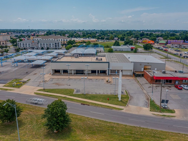
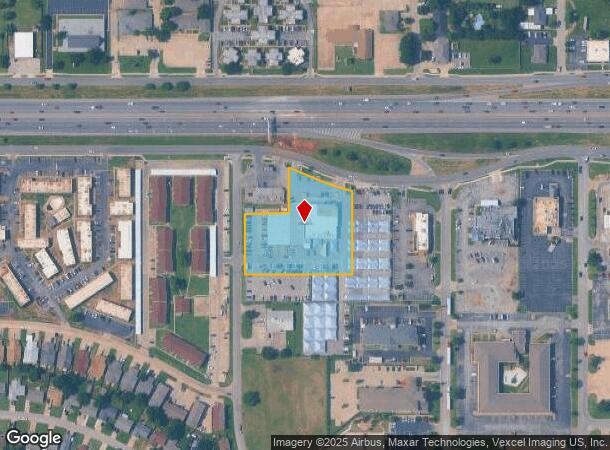
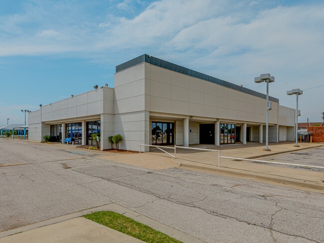
This Property Is For Sale
NEARBY LISTINGS FOR SALE OR LEASE
Property Detail
1030 W I 240 Service Rd
Oklahoma City, OK
Southern Hills
109784355
SOUTHERN HILLS 024 000 PT LOTS 1 2 4 & 7 BEG 595.28FT S & 1220FT W OF NE/C SEC 32 11N 3W TH W343.77FT N198.47FT E140FT N140FT SELY 94.24FT TH SELY ON A CURVE TO THE LEFT 121.18FT S271.95FT TO BEG
Officebuilding
Oklahoma
X
Oklahoma
40027C0043J
1
2023
2.07 AC
2024
South
107206
Oklahoma City
23,688 SF
DEMOGRAPHICS near 1030 W I 240 Service Rd
1 Mile
3 Mile
5 Mile
2024 Total Population
12,201
112,236
211,997
2029 Population
12,395
115,283
218,629
Pop Growth 2024-2029
+ 1.59%
+ 2.71%
+ 3.13%
Average Age
36
36
36
2024 Total Households
4,655
41,927
77,480
HH Growth 2024-2029
+ 1.65%
+ 2.87%
+ 3.27%
Median Household Inc
$38,837
$47,838
$50,683
Avg Household Size
2.50
2.60
2.60
2024 Avg HH Vehicles
2.00
2.00
2.00
Median Home Value
$138,814
$127,913
$134,615
Median Year Built
1970
1972
1974
Nearby Places
- Restaurants
- Banks
- Shops
- Fitness
- Groceries
PUBLIC TRANSPORTATION
COMMUTER RAIL
Oklahoma City (Heartland Flyer - Amtrak)
DRIVE
WALK
Distance
Oklahoma City (Heartland Flyer - Amtrak)
12 min
6.9 mi
AIRPORT
Will Rogers World
DRIVE
WALK
Distance
Will Rogers World
15 min
6.6 mi
Freight Ports
Tulsa Port Of Catoosa
DRIVE
WALK
Distance
Tulsa Port Of Catoosa
143 min
130.2 mi
Nearby Properties
Address
Land Use
TOTAL SIZE
Lot Size
Zoning
Address
Land Use
TOTAL SIZE
Lot Size
Zoning
1,600 SF
25 AC
Address
Land Use
TOTAL SIZE
Lot Size
Zoning
125,954 SF
11.92 AC
R4
Address
Land Use
TOTAL SIZE
Lot Size
Zoning
2,123 SF
53.41 AC
C3
Address
Land Use
TOTAL SIZE
Lot Size
Zoning
192.48 AC
Address
Land Use
TOTAL SIZE
Lot Size
Zoning
57,536 SF
66.21 AC
R4
Address
Land Use
TOTAL SIZE
Lot Size
Zoning
15.61 AC
C1
Address
Land Use
TOTAL SIZE
Lot Size
Zoning
Address
Land Use
TOTAL SIZE
Lot Size
Zoning
64,658 SF
1.86 AC
SPUD
Address
Land Use
TOTAL SIZE
Lot Size
Zoning
10 AC
R2
Address
Land Use
TOTAL SIZE
Lot Size
Zoning
Address
Land Use
TOTAL SIZE
Lot Size
Zoning
347,050 SF
18.56 AC
Address
Land Use
TOTAL SIZE
Lot Size
Zoning
40.90 AC
Address
Land Use
TOTAL SIZE
Lot Size
Zoning
Address
Land Use
TOTAL SIZE
Lot Size
Zoning
384,708 SF
17.05 AC
R-4
Address
Land Use
TOTAL SIZE
Lot Size
Zoning
14,714 SF
14.41 AC
Address
Land Use
TOTAL SIZE
Lot Size
Zoning
104.87 AC
Address
Land Use
TOTAL SIZE
Lot Size
Zoning
27,056 SF
40.77 AC
Address
Land Use
TOTAL SIZE
Lot Size
Zoning
232,037 SF
18.80 AC
C-3
Address
Land Use
TOTAL SIZE
Lot Size
Zoning
403,745 SF
26.03 AC
I-3
Address
Land Use
TOTAL SIZE
Lot Size
Zoning
37,127 SF
21.90 AC
R4
Address
Land Use
TOTAL SIZE
Lot Size
Zoning
239,760 SF
18.52 AC
PUD
Address
Land Use
TOTAL SIZE
Lot Size
Zoning
106,752 SF
6.43 AC
Address
Land Use
TOTAL SIZE
Lot Size
Zoning
2,037 SF
8.36 AC
Address
Land Use
TOTAL SIZE
Lot Size
Zoning
93,886 SF
8.57 AC
CO
Address
Land Use
TOTAL SIZE
Lot Size
Zoning
Address
Land Use
TOTAL SIZE
Lot Size
Zoning
2.55 AC
Address
Land Use
TOTAL SIZE
Lot Size
Zoning
192,405 SF
24.38 AC
Address
Land Use
TOTAL SIZE
Lot Size
Zoning
Address
Land Use
TOTAL SIZE
Lot Size
Zoning
4.83 AC
AA
Address
Land Use
TOTAL SIZE
Lot Size
Zoning
296,429 SF
33.05 AC
I-2
The World's #1 Commercial Real Estate Marketplace
Connect with us
© 2025 CoStar Group
The information above has been obtained from sources believed reliable. While we do not doubt its accuracy we have not verified it and make no guarantee, warranty or representation about it. It is your responsibility to independently confirm its accuracy and completeness. Any projections, opinions, assumptions, or estimates used are for example only and do not represent the current or future performance of the property. The value of this transaction to you depends on tax and other factors which should be evaluated by your tax, financial, and legal advisors. You and your advisors should conduct a careful, independent investigation of the property to determine to your satisfaction the suitability of the property for your needs.