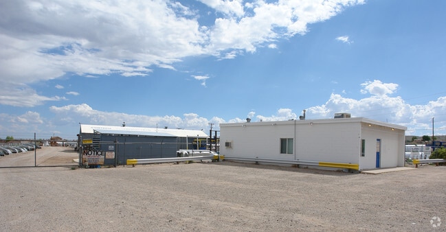
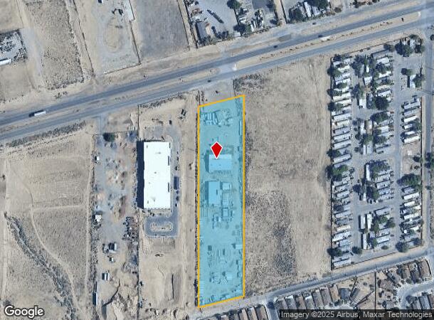
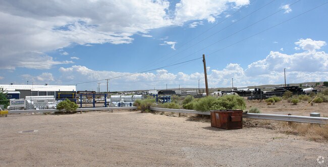
Property Record
10300 Central Ave Sw, Albuquerque, NM 87121
NEARBY LISTINGS FOR SALE OR LEASE
Property Detail
10300 Central Ave Sw
Albuquerque, NM
School District 28
1-008-056-411410-1-05-01
TR 10 ROW 1 SOUTH UNIT B WEST OF WESTLAND AKA LOT 5 BLK 2 LA NDS OF TWN ATR
Manufacturinglight
Bernalillo
X
New Mexico
35001C0328J
5
2024
4.40 AC
2025
South Valley
004712
Albuquerque
1,200 SF
DEMOGRAPHICS near 10300 Central Ave Sw
1 Mile
3 Mile
5 Mile
2024 Total Population
12,040
85,316
146,882
2029 Population
11,791
84,451
145,607
Pop Growth 2024-2029
(2.07%)
(1.01%)
(0.87%)
Average Age
34
35
37
2024 Total Households
3,774
27,885
51,379
HH Growth 2024-2029
(2.23%)
(1.14%)
(0.93%)
Median Household Inc
$55,986
$55,204
$53,144
Avg Household Size
3.10
2.90
2.80
2024 Avg HH Vehicles
2.00
2.00
2.00
Median Home Value
$157,477
$174,055
$184,017
Median Year Built
1996
1999
1992
Nearby Places
Map Layers
Map Styles
 Street
 Aerial
- Restaurants
- Banks
- Shops
- Fitness
- Groceries
PUBLIC TRANSPORTATION
COMMUTER RAIL
Bernalillo County-International Sunport (Rail Runner Express - New Mexico Rail Runner Express)
DRIVE
WALK
Distance
Bernalillo County-International Sunport (Rail Runner Express - New Mexico Rail Runner Express)
15 min
8.3 mi
Downtown Albuquerque (Rail Runner Express - New Mexico Rail Runner Express)
DRIVE
WALK
Distance
Downtown Albuquerque (Rail Runner Express - New Mexico Rail Runner Express)
14 min
9.2 mi
AIRPORT
Albuquerque International Sunport
DRIVE
WALK
Distance
Albuquerque International Sunport
33 min
18.2 mi
Nearby Properties
Address
Land Use
TOTAL SIZE
Lot Size
Zoning
Address
Land Use
TOTAL SIZE
Lot Size
Zoning
755,293 SF
49.94 AC
Address
Land Use
TOTAL SIZE
Lot Size
Zoning
3,693 SF
26.56 AC
Address
Land Use
TOTAL SIZE
Lot Size
Zoning
15.17 AC
Address
Land Use
TOTAL SIZE
Lot Size
Zoning
312,090 SF
35 AC
Address
Land Use
TOTAL SIZE
Lot Size
Zoning
Address
Land Use
TOTAL SIZE
Lot Size
Zoning
196,154 SF
14.81 AC
Address
Land Use
TOTAL SIZE
Lot Size
Zoning
20.08 AC
Address
Land Use
TOTAL SIZE
Lot Size
Zoning
Address
Land Use
TOTAL SIZE
Lot Size
Zoning
256,918 SF
50.96 AC
Address
Land Use
TOTAL SIZE
Lot Size
Zoning
201,339 SF
45.06 AC
Address
Land Use
TOTAL SIZE
Lot Size
Zoning
63,424 SF
9.98 AC
Address
Land Use
TOTAL SIZE
Lot Size
Zoning
151,848 SF
9.69 AC
Address
Land Use
TOTAL SIZE
Lot Size
Zoning
Address
Land Use
TOTAL SIZE
Lot Size
Zoning
60,636 SF
8.93 AC
Address
Land Use
TOTAL SIZE
Lot Size
Zoning
7,382 SF
12.35 AC
Address
Land Use
TOTAL SIZE
Lot Size
Zoning
182,708 SF
23.14 AC
Address
Land Use
TOTAL SIZE
Lot Size
Zoning
202,223 SF
10.57 AC
Address
Land Use
TOTAL SIZE
Lot Size
Zoning
202,320 SF
15.12 AC
Address
Land Use
TOTAL SIZE
Lot Size
Zoning
79,080 SF
50.15 AC
Address
Land Use
TOTAL SIZE
Lot Size
Zoning
16,072 SF
16.30 AC
Address
Land Use
TOTAL SIZE
Lot Size
Zoning
140,180 SF
3.23 AC
Address
Land Use
TOTAL SIZE
Lot Size
Zoning
130,082 SF
20 AC
Address
Land Use
TOTAL SIZE
Lot Size
Zoning
8,992 SF
16.48 AC
Address
Land Use
TOTAL SIZE
Lot Size
Zoning
91,318 SF
20.96 AC
Address
Land Use
TOTAL SIZE
Lot Size
Zoning
147,805 SF
19.94 AC
Address
Land Use
TOTAL SIZE
Lot Size
Zoning
115,768 SF
7.14 AC
Address
Land Use
TOTAL SIZE
Lot Size
Zoning
Address
Land Use
TOTAL SIZE
Lot Size
Zoning
23,375 SF
14.86 AC
Address
Land Use
TOTAL SIZE
Lot Size
Zoning
4,564 SF
102.91 AC
The World's #1 Commercial Real Estate Marketplace
Connect with us
© 2025 CoStar Group
The information above has been obtained from sources believed reliable. While we do not doubt its accuracy we have not verified it and make no guarantee, warranty or representation about it. It is your responsibility to independently confirm its accuracy and completeness. Any projections, opinions, assumptions, or estimates used are for example only and do not represent the current or future performance of the property. The value of this transaction to you depends on tax and other factors which should be evaluated by your tax, financial, and legal advisors. You and your advisors should conduct a careful, independent investigation of the property to determine to your satisfaction the suitability of the property for your needs.