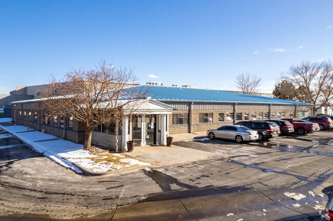
Property Record
10300 E 107Th Pl, Brighton, CO 80601


Save to a Folder
{{folder.Name}}
{{folder.ListingIds.length}} Properties
{{folder.ListingIds.length}} Property
Create a New Folder
Property Detail
10300 E 107Th Pl
Denver-Aurora-Centennial, CO
SUB:DI GIORGIO IND PARK LOT:10
1721-10-0-05-001
Adams
Industrialgeneral
Colorado
B and X Area of moderate flood hazard, usually the area between the limits of the 100-year and 500-year floods.
10
2024
2.79 AC
2025
DIA
008535
Denver
54,521 SF
NEARBY LISTINGS FOR SALE OR LEASE
DEMOGRAPHICS near 10300 E 107Th Pl
1 mile
3 mile
5 mile
2025 Total Population
5,753
27,531
143,904
2030 Population
6,027
28,866
150,115
Pop Growth 2025-2030
+ 4.76%
+ 4.85%
+ 4.32%
Average Age
34
35
36
2025 Total Households
1,895
8,524
47,176
HH Growth 2025-2030
+ 5.07%
+ 5.11%
+ 4.60%
Median Household Inc
$123,654
$130,353
$116,448
Avg Household Size
3.10
3.20
3.00
2025 Avg HH Vehicles
2.00
2.00
2.00
Median Home Value
$490,900
$561,047
$529,399
Median Year Built
2006
2005
2001
Nearby Places
Map Layers
Map Styles
 Street
 Aerial
Layers
 Traffic
 Biking
Places
Listings with unknown addresses are not visible on the map
- Restaurants
- Banks
- Shops
- Fitness
- Groceries
PUBLIC TRANSPORTATION
COMMUTER RAIL
Drive
Walk
Distance
10 min
4.4 mi
Drive
Walk
Distance
11 min
5.9 mi
AIRPORT
Denver International
Drive
Walk
Distance
Denver International
25 min
15.9 mi
SALE & LEASE HISTORY
LISTING DATE
SALE/LEASE

Feb 01, 2023
For Lease
Apr 02, 2021
For Sale
Nearby Properties
Address
Land Use
TOTAL SIZE
Lot Size
Zoning
Address
Land Use
TOTAL SIZE
Lot Size
Zoning
279,946 SF
11.55 AC
Address
Land Use
TOTAL SIZE
Lot Size
Zoning
8,556 SF
382.73 AC
A3
Address
Land Use
TOTAL SIZE
Lot Size
Zoning
358,386 SF
76.08 AC
Address
Land Use
TOTAL SIZE
Lot Size
Zoning
276,395 SF
26.43 AC
A3
Address
Land Use
TOTAL SIZE
Lot Size
Zoning
549,866 SF
33.82 AC
Address
Land Use
TOTAL SIZE
Lot Size
Zoning
624.70 AC
A3
Address
Land Use
TOTAL SIZE
Lot Size
Zoning
624.02 AC
A3
Address
Land Use
TOTAL SIZE
Lot Size
Zoning
616.10 AC
A3
Address
Land Use
TOTAL SIZE
Lot Size
Zoning
330,176 SF
17.12 AC
Address
Land Use
TOTAL SIZE
Lot Size
Zoning
328,674 SF
47.13 AC
Address
Land Use
TOTAL SIZE
Lot Size
Zoning
298,200 SF
17.67 AC
Address
Land Use
TOTAL SIZE
Lot Size
Zoning
172,816 SF
59.89 AC
Address
Land Use
TOTAL SIZE
Lot Size
Zoning
258,279 SF
70.11 AC
I2
Address
Land Use
TOTAL SIZE
Lot Size
Zoning
272,800 SF
16.44 AC
Address
Land Use
TOTAL SIZE
Lot Size
Zoning
208,864 SF
19.26 AC
Address
Land Use
TOTAL SIZE
Lot Size
Zoning
2,240 SF
128.54 AC
A1
Address
Land Use
TOTAL SIZE
Lot Size
Zoning
64,750 SF
11.91 AC
Address
Land Use
TOTAL SIZE
Lot Size
Zoning
199,500 SF
15.03 AC
Address
Land Use
TOTAL SIZE
Lot Size
Zoning
158,001 SF
20.40 AC
Address
Land Use
TOTAL SIZE
Lot Size
Zoning
96,628 SF
4.35 AC
Address
Land Use
TOTAL SIZE
Lot Size
Zoning
204,000 SF
9.96 AC
Address
Land Use
TOTAL SIZE
Lot Size
Zoning
140,712 SF
18.29 AC
Address
Land Use
TOTAL SIZE
Lot Size
Zoning
86,225 SF
13.55 AC
Address
Land Use
TOTAL SIZE
Lot Size
Zoning
127,109 SF
19.96 AC
Address
Land Use
TOTAL SIZE
Lot Size
Zoning
64,501 SF
29.37 AC
Address
Land Use
TOTAL SIZE
Lot Size
Zoning
121,275 SF
6.56 AC
Address
Land Use
TOTAL SIZE
Lot Size
Zoning
76,279 SF
25.01 AC
Address
Land Use
TOTAL SIZE
Lot Size
Zoning
48,359 SF
278.79 AC
A3
Address
Land Use
TOTAL SIZE
Lot Size
Zoning
139,356 SF
20.24 AC
I2
Address
Land Use
TOTAL SIZE
Lot Size
Zoning
64,715 SF
10.38 AC
The World's #1 Commercial Real Estate Marketplace
Connect with us
© 2026 CoStar Group
The information above has been obtained from sources believed reliable. While we do not doubt its accuracy we have not verified it and make no guarantee, warranty or representation about it. It is your responsibility to independently confirm its accuracy and completeness. Any projections, opinions, assumptions, or estimates used are for example only and do not represent the current or future performance of the property. The value of this transaction to you depends on tax and other factors which should be evaluated by your tax, financial, and legal advisors. You and your advisors should conduct a careful, independent investigation of the property to determine to your satisfaction the suitability of the property for your needs.