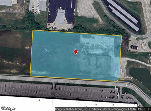
Property Record
10300 Schuster Way Sw, Pataskala, OH 43062
NEARBY LISTINGS FOR SALE OR LEASE
Property Detail
10300 Schuster Way Sw
Columbus, OH
LOT 4B ETNA 70 BUSINESS PARK WEST (13.773 AC) TAX ABATE CRA 2024-2038
010-018264-00.007
Licking
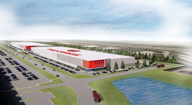
Publicstorage
Ohio
2024
4b
2024
13.77 AC
756500
Licking County
252,322 SF
Columbus
DEMOGRAPHICS near 10300 Schuster Way Sw
1 Mile
3 Mile
5 Mile
2024 Total Population
1,767
13,777
55,306
2029 Population
1,833
14,575
58,469
Pop Growth 2024-2029
+ 3.74%
+ 5.79%
+ 5.72%
Average Age
37
39
40
2024 Total Households
597
4,828
19,383
HH Growth 2024-2029
+ 3.69%
+ 5.49%
+ 5.59%
Median Household Inc
$104,878
$100,573
$101,077
Avg Household Size
2.80
2.80
2.80
2024 Avg HH Vehicles
3.00
2.00
2.00
Median Home Value
$227,122
$262,466
$266,646
Median Year Built
1996
1994
1992
Nearby Places
Map Layers
Map Styles
 Street
 Aerial
- Restaurants
- Banks
- Shops
- Fitness
- Groceries
PUBLIC TRANSPORTATION
AIRPORT
John Glenn Columbus International
DRIVE
WALK
Distance
John Glenn Columbus International
26 min
18.3 mi
Rickenbacker International
DRIVE
WALK
Distance
Rickenbacker International
29 min
20.5 mi
Freight Ports
Port of Toledo
DRIVE
WALK
Distance
Port of Toledo
199 min
158.1 mi
SALE & LEASE HISTORY
LISTING DATE
SALE/LEASE

Feb 18, 2020
For Lease
Aug 15, 2019
For Lease
Apr 16, 2018
For Lease
Nearby Properties
Address
Land Use
TOTAL SIZE
Lot Size
Zoning
Address
Land Use
TOTAL SIZE
Lot Size
Zoning
1,230,350 SF
78.26 AC
Address
Land Use
TOTAL SIZE
Lot Size
Zoning
1,191,656 SF
56.97 AC
Address
Land Use
TOTAL SIZE
Lot Size
Zoning
1,078,218 SF
63.12 AC
Address
Land Use
TOTAL SIZE
Lot Size
Zoning
1,014,005 SF
101.26 AC
Address
Land Use
TOTAL SIZE
Lot Size
Zoning
855,000 SF
96 AC
Address
Land Use
TOTAL SIZE
Lot Size
Zoning
588,910 SF
52.23 AC
Address
Land Use
TOTAL SIZE
Lot Size
Zoning
437,569 SF
33 AC
Address
Land Use
TOTAL SIZE
Lot Size
Zoning
700,491 SF
92.80 AC
Address
Land Use
TOTAL SIZE
Lot Size
Zoning
699,016 SF
43.57 AC
Address
Land Use
TOTAL SIZE
Lot Size
Zoning
756,333 SF
44.37 AC
Address
Land Use
TOTAL SIZE
Lot Size
Zoning
179.65 AC
Address
Land Use
TOTAL SIZE
Lot Size
Zoning
524,490 SF
25.40 AC
Address
Land Use
TOTAL SIZE
Lot Size
Zoning
524,494 SF
25.67 AC
Address
Land Use
TOTAL SIZE
Lot Size
Zoning
410,332 SF
21.81 AC
Address
Land Use
TOTAL SIZE
Lot Size
Zoning
512,267 SF
22.36 AC
Address
Land Use
TOTAL SIZE
Lot Size
Zoning
73,671 SF
80.57 AC
Address
Land Use
TOTAL SIZE
Lot Size
Zoning
303,408 SF
29.74 AC
Address
Land Use
TOTAL SIZE
Lot Size
Zoning
183,545 SF
43.70 AC
Address
Land Use
TOTAL SIZE
Lot Size
Zoning
9,408 SF
12.53 AC
Address
Land Use
TOTAL SIZE
Lot Size
Zoning
78,136 SF
7.46 AC
Address
Land Use
TOTAL SIZE
Lot Size
Zoning
53,202 SF
38.44 AC
Address
Land Use
TOTAL SIZE
Lot Size
Zoning
14,790 SF
8.18 AC
Address
Land Use
TOTAL SIZE
Lot Size
Zoning
9,600 SF
6.36 AC
Address
Land Use
TOTAL SIZE
Lot Size
Zoning
54,972 SF
15 AC
Address
Land Use
TOTAL SIZE
Lot Size
Zoning
6,872 SF
10 AC
Address
Land Use
TOTAL SIZE
Lot Size
Zoning
34,559 SF
43.32 AC
Address
Land Use
TOTAL SIZE
Lot Size
Zoning
88,476 SF
8.98 AC
Address
Land Use
TOTAL SIZE
Lot Size
Zoning
1,649 SF
114 AC
Address
Land Use
TOTAL SIZE
Lot Size
Zoning
75,680 SF
20 AC
The World's #1 Commercial Real Estate Marketplace
Connect with us
© 2025 CoStar Group
The information above has been obtained from sources believed reliable. While we do not doubt its accuracy we have not verified it and make no guarantee, warranty or representation about it. It is your responsibility to independently confirm its accuracy and completeness. Any projections, opinions, assumptions, or estimates used are for example only and do not represent the current or future performance of the property. The value of this transaction to you depends on tax and other factors which should be evaluated by your tax, financial, and legal advisors. You and your advisors should conduct a careful, independent investigation of the property to determine to your satisfaction the suitability of the property for your needs.