Property Record
10300 Us Highway 19 N, Pinellas Park, FL 33782
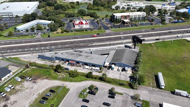
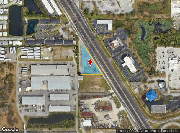
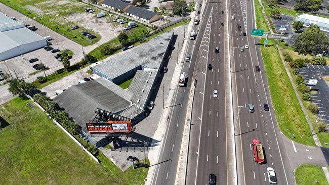
This Property Is For Sale
NEARBY LISTINGS FOR SALE OR LEASE
Property Detail
10300 Us Highway 19 N
16-30-16-69732-400-5202
Pinellas Farms
Warehouse
PINELLAS FARMS SE 1/4, SEC 16-30-16 THAT PART OF FARM 52 LYING SWLY OF US 19
X
Pinellas
12103C0202J
Florida
2024
1.11 AC
2025
South Pinellas
024505
Tampa/St Petersburg
24,471 SF
Tampa-St. Petersburg-Clearwater, FL
DEMOGRAPHICS near 10300 Us Highway 19 N
1 Mile
3 Mile
5 Mile
2024 Total Population
11,141
71,209
244,395
2029 Population
11,117
71,701
245,055
Pop Growth 2024-2029
(0.22%)
+ 0.69%
+ 0.27%
Average Age
45
44
44
2024 Total Households
4,760
31,252
111,218
HH Growth 2024-2029
(0.32%)
+ 0.72%
+ 0.14%
Median Household Inc
$55,134
$57,997
$56,828
Avg Household Size
2.20
2.20
2.10
2024 Avg HH Vehicles
2.00
2.00
2.00
Median Home Value
$205,962
$214,345
$213,847
Median Year Built
1974
1978
1976
Nearby Places
- Restaurants
- Banks
- Shops
- Fitness
- Groceries
PUBLIC TRANSPORTATION
AIRPORT
St Pete-Clearwater International
DRIVE
WALK
Distance
St Pete-Clearwater International
16 min
6.5 mi
Tampa International
DRIVE
WALK
Distance
Tampa International
28 min
17.4 mi
Freight Ports
Port of Tampa Bay
DRIVE
WALK
Distance
Port of Tampa Bay
35 min
23.1 mi
Nearby Properties
Address
Land Use
TOTAL SIZE
Lot Size
Zoning
Address
Land Use
TOTAL SIZE
Lot Size
Zoning
795,890 SF
69.11 AC
M1
Address
Land Use
TOTAL SIZE
Lot Size
Zoning
130,544 SF
1,313.50 AC
PCAIRPOR
Address
Land Use
TOTAL SIZE
Lot Size
Zoning
1,232,878 SF
12.64 AC
Address
Land Use
TOTAL SIZE
Lot Size
Zoning
428,587 SF
14.35 AC
Address
Land Use
TOTAL SIZE
Lot Size
Zoning
372,013 SF
10.10 AC
Address
Land Use
TOTAL SIZE
Lot Size
Zoning
447,664 SF
34.44 AC
Address
Land Use
TOTAL SIZE
Lot Size
Zoning
171,420 SF
300.24 AC
M1
Address
Land Use
TOTAL SIZE
Lot Size
Zoning
350,604 SF
13.21 AC
Address
Land Use
TOTAL SIZE
Lot Size
Zoning
416,482 SF
14.93 AC
Address
Land Use
TOTAL SIZE
Lot Size
Zoning
346,420 SF
17.95 AC
Address
Land Use
TOTAL SIZE
Lot Size
Zoning
372,436 SF
22.30 AC
Address
Land Use
TOTAL SIZE
Lot Size
Zoning
382,389 SF
13.62 AC
Address
Land Use
TOTAL SIZE
Lot Size
Zoning
404,063 SF
12.98 AC
Address
Land Use
TOTAL SIZE
Lot Size
Zoning
404,899 SF
35.35 AC
Address
Land Use
TOTAL SIZE
Lot Size
Zoning
401,627 SF
0.66 AC
Address
Land Use
TOTAL SIZE
Lot Size
Zoning
358,681 SF
11.70 AC
Address
Land Use
TOTAL SIZE
Lot Size
Zoning
240,736 SF
58.40 AC
Address
Land Use
TOTAL SIZE
Lot Size
Zoning
402,681 SF
18.40 AC
Address
Land Use
TOTAL SIZE
Lot Size
Zoning
255,548 SF
21.69 AC
RPD10
Address
Land Use
TOTAL SIZE
Lot Size
Zoning
311,000 SF
15.50 AC
Address
Land Use
TOTAL SIZE
Lot Size
Zoning
446,556 SF
14.95 AC
M1
Address
Land Use
TOTAL SIZE
Lot Size
Zoning
300,546 SF
6.49 AC
Address
Land Use
TOTAL SIZE
Lot Size
Zoning
362,618 SF
40.19 AC
R6
Address
Land Use
TOTAL SIZE
Lot Size
Zoning
266,396 SF
23.18 AC
Address
Land Use
TOTAL SIZE
Lot Size
Zoning
294,478 SF
44.79 AC
M1
Address
Land Use
TOTAL SIZE
Lot Size
Zoning
250,000 SF
21.44 AC
Address
Land Use
TOTAL SIZE
Lot Size
Zoning
62,948 SF
12.11 AC
Address
Land Use
TOTAL SIZE
Lot Size
Zoning
423,776 SF
20.91 AC
Address
Land Use
TOTAL SIZE
Lot Size
Zoning
240,392 SF
58.32 AC
Address
Land Use
TOTAL SIZE
Lot Size
Zoning
206,685 SF
16.75 AC
RPD5
The World's #1 Commercial Real Estate Marketplace
Connect with us
© 2025 CoStar Group
The information above has been obtained from sources believed reliable. While we do not doubt its accuracy we have not verified it and make no guarantee, warranty or representation about it. It is your responsibility to independently confirm its accuracy and completeness. Any projections, opinions, assumptions, or estimates used are for example only and do not represent the current or future performance of the property. The value of this transaction to you depends on tax and other factors which should be evaluated by your tax, financial, and legal advisors. You and your advisors should conduct a careful, independent investigation of the property to determine to your satisfaction the suitability of the property for your needs.