Property Record
W 102Nd St, Cleveland, OH 44102
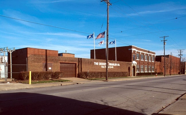
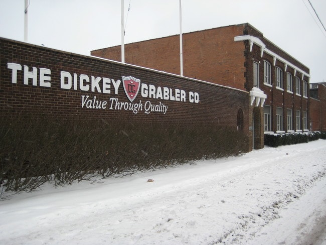
This Property Is For Sale
NEARBY LISTINGS FOR SALE OR LEASE
Property Detail
W 102Nd St
Cleveland-Elyria, OH
Jennings Wetmore Schilling & O
001-27-027
9 JENNINGS S/L 27 SEP 0026 SWP
Lightindustrial
Cuyahoga
X
Ohio
39035C0157F
26
2024
0.09 AC
2024
Lakewood
101501
Cleveland
DEMOGRAPHICS near W 102Nd St
1 Mile
3 Mile
5 Mile
2024 Total Population
24,104
140,899
269,475
2029 Population
23,429
136,371
261,975
Pop Growth 2024-2029
(2.80%)
(3.21%)
(2.78%)
Average Age
38
38
39
2024 Total Households
11,420
65,239
125,960
HH Growth 2024-2029
(2.82%)
(3.24%)
(2.73%)
Median Household Inc
$36,777
$46,412
$50,242
Avg Household Size
2.00
2.10
2.00
2024 Avg HH Vehicles
1.00
1.00
1.00
Median Home Value
$126,907
$145,367
$147,787
Median Year Built
1947
1947
1948
Nearby Places
Map Layers
Map Styles
 Street
 Aerial
- Restaurants
- Banks
- Shops
- Fitness
- Groceries
PUBLIC TRANSPORTATION
TRANSIT/SUBWAY
West Blvd-Cudell Station (Red Line - Greater Cleveland Regional Transit Authority)
DRIVE
WALK
Distance
West Blvd-Cudell Station (Red Line - Greater Cleveland Regional Transit Authority)
2 min
7 min
0.4 mi
West Boulevard - Cudell (Red Line - Greater Cleveland Regional Transit Authority Rapid Transit (The Rapid))
DRIVE
WALK
Distance
West Boulevard - Cudell (Red Line - Greater Cleveland Regional Transit Authority Rapid Transit (The Rapid))
2 min
7 min
0.4 mi
W 117Th St-Madison Av Station (Red Line - Greater Cleveland Regional Transit Authority)
DRIVE
WALK
Distance
W 117Th St-Madison Av Station (Red Line - Greater Cleveland Regional Transit Authority)
2 min
17 min
0.9 mi
West 117 - Madison (Red Line - Greater Cleveland Regional Transit Authority Rapid Transit (The Rapid))
DRIVE
WALK
Distance
West 117 - Madison (Red Line - Greater Cleveland Regional Transit Authority Rapid Transit (The Rapid))
2 min
17 min
0.9 mi
COMMUTER RAIL
Cleveland Lakefront Station (Blue Line - Greater Cleveland Regional Transit Authority Rapid Transit (The Rapid), Green Line - Greater Cleveland Regional Transit Authority Rapid Transit (The Rapid))
DRIVE
WALK
Distance
Cleveland Lakefront Station (Blue Line - Greater Cleveland Regional Transit Authority Rapid Transit (The Rapid), Green Line - Greater Cleveland Regional Transit Authority Rapid Transit (The Rapid))
14 min
6.0 mi
AIRPORT
Cleveland-Hopkins International
DRIVE
WALK
Distance
Cleveland-Hopkins International
20 min
8.9 mi
Freight Ports
Port of Toledo
DRIVE
WALK
Distance
Port of Toledo
131 min
109.3 mi
Nearby Properties
Address
Land Use
TOTAL SIZE
Lot Size
Zoning
Address
Land Use
TOTAL SIZE
Lot Size
Zoning
5,100 SF
9.41 AC
GI
Address
Land Use
TOTAL SIZE
Lot Size
Zoning
3.23 AC
LLR
Address
Land Use
TOTAL SIZE
Lot Size
Zoning
70.02 AC
GI
Address
Land Use
TOTAL SIZE
Lot Size
Zoning
299,507 SF
2.14 AC
LR
Address
Land Use
TOTAL SIZE
Lot Size
Zoning
2.83 AC
LLR
Address
Land Use
TOTAL SIZE
Lot Size
Zoning
518,244 SF
21.80 AC
Address
Land Use
TOTAL SIZE
Lot Size
Zoning
300,000 SF
2.07 AC
Address
Land Use
TOTAL SIZE
Lot Size
Zoning
208,209 SF
12.10 AC
1F
Address
Land Use
TOTAL SIZE
Lot Size
Zoning
164,294 SF
13.81 AC
GI
Address
Land Use
TOTAL SIZE
Lot Size
Zoning
320,334 SF
4 AC
GR
Address
Land Use
TOTAL SIZE
Lot Size
Zoning
200,874 SF
3.30 AC
LR
Address
Land Use
TOTAL SIZE
Lot Size
Zoning
242,515 SF
1.01 AC
Address
Land Use
TOTAL SIZE
Lot Size
Zoning
340,593 SF
10.10 AC
G-1
Address
Land Use
TOTAL SIZE
Lot Size
Zoning
308,339 SF
9.78 AC
2F
Address
Land Use
TOTAL SIZE
Lot Size
Zoning
168,750 SF
18.55 AC
GI
Address
Land Use
TOTAL SIZE
Lot Size
Zoning
123,130 SF
21.88 AC
GI
Address
Land Use
TOTAL SIZE
Lot Size
Zoning
28,852 SF
8.17 AC
Address
Land Use
TOTAL SIZE
Lot Size
Zoning
3.96 AC
Address
Land Use
TOTAL SIZE
Lot Size
Zoning
258,852 SF
5.20 AC
MF2
Address
Land Use
TOTAL SIZE
Lot Size
Zoning
142,935 SF
1.02 AC
LR
Address
Land Use
TOTAL SIZE
Lot Size
Zoning
22,928 SF
2.17 AC
LR
Address
Land Use
TOTAL SIZE
Lot Size
Zoning
104,170 SF
2.70 AC
2F
Address
Land Use
TOTAL SIZE
Lot Size
Zoning
389,067 SF
12.05 AC
A-H
Address
Land Use
TOTAL SIZE
Lot Size
Zoning
372,786 SF
4.79 AC
MF3+
Address
Land Use
TOTAL SIZE
Lot Size
Zoning
145,936 SF
1.05 AC
2F
Address
Land Use
TOTAL SIZE
Lot Size
Zoning
155,896 SF
5.03 AC
Address
Land Use
TOTAL SIZE
Lot Size
Zoning
616,636 SF
3.28 AC
MF-2
Address
Land Use
TOTAL SIZE
Lot Size
Zoning
59,913 SF
0.92 AC
LR
Address
Land Use
TOTAL SIZE
Lot Size
Zoning
128,902 SF
7.12 AC
PD
Address
Land Use
TOTAL SIZE
Lot Size
Zoning
126,661 SF
7.07 AC
PD
The World's #1 Commercial Real Estate Marketplace
Connect with us
© 2025 CoStar Group
The information above has been obtained from sources believed reliable. While we do not doubt its accuracy we have not verified it and make no guarantee, warranty or representation about it. It is your responsibility to independently confirm its accuracy and completeness. Any projections, opinions, assumptions, or estimates used are for example only and do not represent the current or future performance of the property. The value of this transaction to you depends on tax and other factors which should be evaluated by your tax, financial, and legal advisors. You and your advisors should conduct a careful, independent investigation of the property to determine to your satisfaction the suitability of the property for your needs.