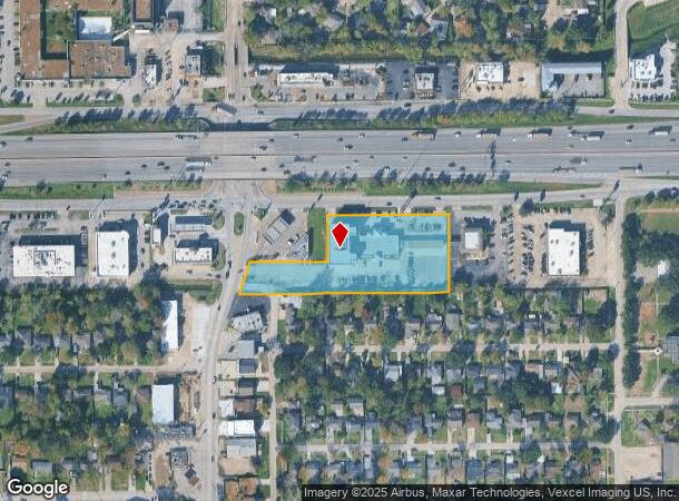
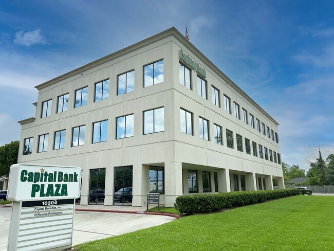
Property Record
10304 East Fwy, Houston, TX 77029

Current Lease Availabilities
NEARBY LISTINGS FOR SALE OR LEASE
-
-
-
-
No Photo
-
-
-
-
View all Houston listings for lease on LoopNet.com
Property Detail
10304 East Fwy
0432110000053
Abst 545 C Martinez
Officebuilding
TRS 5A-1 & 5B-1 ABST 545 C MARTINEZ
X
Harris
48201C0715M
Texas
2024
2.52 AC
2025
Pasadena/Galena Park
233400
Houston
35,138 SF
Houston-The Woodlands-Sugar Land, TX
DEMOGRAPHICS near 10304 East Fwy
1 Mile
3 Mile
5 Mile
2024 Total Population
9,879
59,380
188,497
2029 Population
10,043
60,875
193,357
Pop Growth 2024-2029
+ 1.66%
+ 2.52%
+ 2.58%
Average Age
37
36
36
2024 Total Households
3,155
18,836
61,180
HH Growth 2024-2029
+ 1.58%
+ 2.52%
+ 2.57%
Median Household Inc
$44,347
$42,328
$41,294
Avg Household Size
3.10
3.10
3.00
2024 Avg HH Vehicles
2.00
2.00
2.00
Median Home Value
$118,348
$106,265
$121,944
Median Year Built
1961
1964
1967
Nearby Places
Map Layers
Map Styles
 Street
 Aerial
- Restaurants
- Banks
- Shops
- Fitness
- Groceries
PUBLIC TRANSPORTATION
COMMUTER RAIL
Houston (Sunset Limited - Amtrak)
DRIVE
WALK
Distance
Houston (Sunset Limited - Amtrak)
13 min
8.1 mi
AIRPORT
William P Hobby
DRIVE
WALK
Distance
William P Hobby
24 min
13.0 mi
George Bush Intcntl/Houston
DRIVE
WALK
Distance
George Bush Intcntl/Houston
29 min
21.1 mi
Freight Ports
Port of Houston
DRIVE
WALK
Distance
Port of Houston
11 min
5.0 mi
Nearby Properties
Address
Land Use
TOTAL SIZE
Lot Size
Zoning
Address
Land Use
TOTAL SIZE
Lot Size
Zoning
100.26 AC
Address
Land Use
TOTAL SIZE
Lot Size
Zoning
12,206,592 SF
212.18 AC
Address
Land Use
TOTAL SIZE
Lot Size
Zoning
1,970,716 SF
118.84 AC
Address
Land Use
TOTAL SIZE
Lot Size
Zoning
1,392,720 SF
83.75 AC
Address
Land Use
TOTAL SIZE
Lot Size
Zoning
793,077 SF
49.76 AC
Address
Land Use
TOTAL SIZE
Lot Size
Zoning
663,147 SF
40.63 AC
Address
Land Use
TOTAL SIZE
Lot Size
Zoning
520,866 SF
23.25 AC
Address
Land Use
TOTAL SIZE
Lot Size
Zoning
422,526 SF
27.45 AC
Address
Land Use
TOTAL SIZE
Lot Size
Zoning
351,250 SF
23.84 AC
Address
Land Use
TOTAL SIZE
Lot Size
Zoning
450,084 SF
15.13 AC
Address
Land Use
TOTAL SIZE
Lot Size
Zoning
Address
Land Use
TOTAL SIZE
Lot Size
Zoning
343,265 SF
41.52 AC
Address
Land Use
TOTAL SIZE
Lot Size
Zoning
889,587 SF
137.68 AC
Address
Land Use
TOTAL SIZE
Lot Size
Zoning
Address
Land Use
TOTAL SIZE
Lot Size
Zoning
240,968 SF
12.45 AC
Address
Land Use
TOTAL SIZE
Lot Size
Zoning
235,624 SF
10.06 AC
Address
Land Use
TOTAL SIZE
Lot Size
Zoning
208,648 SF
8.99 AC
Address
Land Use
TOTAL SIZE
Lot Size
Zoning
246,277 SF
10.91 AC
Address
Land Use
TOTAL SIZE
Lot Size
Zoning
190,512 SF
8.81 AC
Address
Land Use
TOTAL SIZE
Lot Size
Zoning
141,017 SF
11.90 AC
Address
Land Use
TOTAL SIZE
Lot Size
Zoning
532,658 SF
36.31 AC
Address
Land Use
TOTAL SIZE
Lot Size
Zoning
225,393 SF
20.59 AC
Address
Land Use
TOTAL SIZE
Lot Size
Zoning
264,866 SF
10.46 AC
Address
Land Use
TOTAL SIZE
Lot Size
Zoning
205,768 SF
9.51 AC
Address
Land Use
TOTAL SIZE
Lot Size
Zoning
163,807 SF
8.58 AC
Address
Land Use
TOTAL SIZE
Lot Size
Zoning
175,172 SF
8.81 AC
Address
Land Use
TOTAL SIZE
Lot Size
Zoning
265,232 SF
13.31 AC
Address
Land Use
TOTAL SIZE
Lot Size
Zoning
250,929 SF
13.17 AC
Address
Land Use
TOTAL SIZE
Lot Size
Zoning
76,842 SF
49.76 AC
Address
Land Use
TOTAL SIZE
Lot Size
Zoning
149,052 SF
7.48 AC
The World's #1 Commercial Real Estate Marketplace
Connect with us
© 2026 CoStar Group
The information above has been obtained from sources believed reliable. While we do not doubt its accuracy we have not verified it and make no guarantee, warranty or representation about it. It is your responsibility to independently confirm its accuracy and completeness. Any projections, opinions, assumptions, or estimates used are for example only and do not represent the current or future performance of the property. The value of this transaction to you depends on tax and other factors which should be evaluated by your tax, financial, and legal advisors. You and your advisors should conduct a careful, independent investigation of the property to determine to your satisfaction the suitability of the property for your needs.