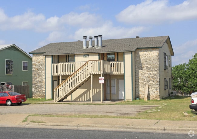
Property Record
10309 Brownie Dr, Austin, TX 78753

NEARBY LISTINGS FOR SALE OR LEASE
Property Detail
10309 Brownie Dr
Austin-Round Rock, TX
Western Trails Of Quail Creeksec 5
249394
LOT 16 BLK L WESTERN TRAILS OF QUAIL CREEKSEC 5
Quadruplex
Travis
X
Texas
48453C0460K
16
2024
0.29 AC
2025
North Lamar
041000
Austin
3,120 SF
DEMOGRAPHICS near 10309 Brownie Dr
1 Mile
3 Mile
5 Mile
2024 Total Population
22,357
140,955
334,318
2029 Population
24,078
153,175
363,448
Pop Growth 2024-2029
+ 7.70%
+ 8.67%
+ 8.71%
Average Age
36
36
37
2024 Total Households
7,618
57,895
145,315
HH Growth 2024-2029
+ 8.37%
+ 9.50%
+ 9.41%
Median Household Inc
$53,656
$58,152
$70,375
Avg Household Size
2.70
2.30
2.20
2024 Avg HH Vehicles
2.00
2.00
2.00
Median Home Value
$279,558
$337,535
$404,089
Median Year Built
1979
1987
1989
Nearby Places
Map Layers
Map Styles
 Street
 Aerial
- Restaurants
- Banks
- Shops
- Fitness
- Groceries
PUBLIC TRANSPORTATION
COMMUTER RAIL
Austin (Texas Eagle - Amtrak)
DRIVE
WALK
Distance
Austin (Texas Eagle - Amtrak)
15 min
9.6 mi
AIRPORT
Austin-Bergstrom International
DRIVE
WALK
Distance
Austin-Bergstrom International
30 min
18.4 mi
Freight Ports
Calhoun Port
DRIVE
WALK
Distance
Calhoun Port
195 min
161.9 mi
SALE & LEASE HISTORY
LISTING DATE
SALE/LEASE

Jun 27, 2018
For Sale
Nearby Properties
Address
Land Use
TOTAL SIZE
Lot Size
Zoning
Address
Land Use
TOTAL SIZE
Lot Size
Zoning
230.30 AC
Address
Land Use
TOTAL SIZE
Lot Size
Zoning
702,590 SF
48.64 AC
Address
Land Use
TOTAL SIZE
Lot Size
Zoning
1,145,461 SF
34.05 AC
Address
Land Use
TOTAL SIZE
Lot Size
Zoning
323,406 SF
2.36 AC
Address
Land Use
TOTAL SIZE
Lot Size
Zoning
571,738 SF
36.06 AC
Address
Land Use
TOTAL SIZE
Lot Size
Zoning
340,785 SF
1.89 AC
Address
Land Use
TOTAL SIZE
Lot Size
Zoning
340,000 SF
1.54 AC
Address
Land Use
TOTAL SIZE
Lot Size
Zoning
311,025 SF
4.99 AC
Address
Land Use
TOTAL SIZE
Lot Size
Zoning
287,272 SF
17.68 AC
Address
Land Use
TOTAL SIZE
Lot Size
Zoning
348,496 SF
17.59 AC
Address
Land Use
TOTAL SIZE
Lot Size
Zoning
351,012 SF
16.40 AC
Address
Land Use
TOTAL SIZE
Lot Size
Zoning
314,319 SF
5.97 AC
Address
Land Use
TOTAL SIZE
Lot Size
Zoning
377,769 SF
20.97 AC
Address
Land Use
TOTAL SIZE
Lot Size
Zoning
379,500 SF
17.99 AC
Address
Land Use
TOTAL SIZE
Lot Size
Zoning
286,276 SF
4.53 AC
Address
Land Use
TOTAL SIZE
Lot Size
Zoning
276,772 SF
4.68 AC
Address
Land Use
TOTAL SIZE
Lot Size
Zoning
359,458 SF
18.50 AC
Address
Land Use
TOTAL SIZE
Lot Size
Zoning
299,957 SF
22.02 AC
Address
Land Use
TOTAL SIZE
Lot Size
Zoning
709,789 SF
52.90 AC
Address
Land Use
TOTAL SIZE
Lot Size
Zoning
521,820 SF
4.68 AC
Address
Land Use
TOTAL SIZE
Lot Size
Zoning
459,304 SF
28.36 AC
Address
Land Use
TOTAL SIZE
Lot Size
Zoning
752,804 SF
180.91 AC
Address
Land Use
TOTAL SIZE
Lot Size
Zoning
244,809 SF
5.45 AC
Address
Land Use
TOTAL SIZE
Lot Size
Zoning
311,850 SF
18.09 AC
Address
Land Use
TOTAL SIZE
Lot Size
Zoning
270,780 SF
18.17 AC
Address
Land Use
TOTAL SIZE
Lot Size
Zoning
384,776 SF
22.88 AC
Address
Land Use
TOTAL SIZE
Lot Size
Zoning
233,475 SF
2.94 AC
Address
Land Use
TOTAL SIZE
Lot Size
Zoning
264,401 SF
10.48 AC
Address
Land Use
TOTAL SIZE
Lot Size
Zoning
237,603 SF
8.38 AC
Address
Land Use
TOTAL SIZE
Lot Size
Zoning
374,432 SF
14.28 AC
The World's #1 Commercial Real Estate Marketplace
Connect with us
© 2026 CoStar Group
The information above has been obtained from sources believed reliable. While we do not doubt its accuracy we have not verified it and make no guarantee, warranty or representation about it. It is your responsibility to independently confirm its accuracy and completeness. Any projections, opinions, assumptions, or estimates used are for example only and do not represent the current or future performance of the property. The value of this transaction to you depends on tax and other factors which should be evaluated by your tax, financial, and legal advisors. You and your advisors should conduct a careful, independent investigation of the property to determine to your satisfaction the suitability of the property for your needs.